
This item below is out of stock, but another example (left) is available. To view the available item, click "Details."
Details
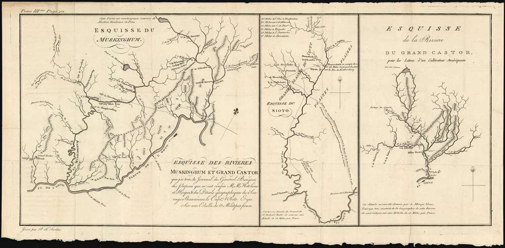
1787 Tardieu Map of the Ohio River, Muskingum River, Scioto River, and Beaver River
1787 (undated) $400.00
1787 Tardieu Map of the Ohio River, Muskingum River, Scioto River, and Beaver River
EsquisseRivieres3-tardieu-1787$200.00

Title
Esquisse des rivieres Muskinghum et Grand Castor que j'ai tiree du Journal du General Bouquet.
1787 (undated) 9.5 x 21 in (24.13 x 53.34 cm)
1787 (undated) 9.5 x 21 in (24.13 x 53.34 cm)
Description
This is a scarce 1787 map of the Ohio River and its tributaries by Pierre Tardieu. Divided into three maps, this is one of the earliest maps of the region. The large map in the left depicts the course of the Ohio River from western Pennsylvania to the confluence of the Hockhoking River. The Sandusky River, which flows north into Lake Erie, appears at the top of the map. Its primary focus is the course of the Muskinghum River, the largest of the Ohio's tributaries in the region and the site of many indigenous and European settlements.
The center map depicts the Scioto River and its various tributaries, showing many indigenous settlements in the future location of Columbus, Ohio. The third map features the River Grand Castor - now known as the Beaver River, in Western Pennsylvania - and its tributaries. As in the other two maps, native and European settlements are noted throughout, with mountains beautifully rendered in profile. All three maps note sources for salt, trails between settlements, and native warpaths.
The center map depicts the Scioto River and its various tributaries, showing many indigenous settlements in the future location of Columbus, Ohio. The third map features the River Grand Castor - now known as the Beaver River, in Western Pennsylvania - and its tributaries. As in the other two maps, native and European settlements are noted throughout, with mountains beautifully rendered in profile. All three maps note sources for salt, trails between settlements, and native warpaths.
Publication History
Based on earlier maps from Bouquet and Hutchins, this map was issued in the 1787 French edition of J. Hector St. John de Crevecoeur's Letter from an American Farmer Though we are aware of examples that have come on the market, this map only appears separately in only four institutional collections.Cartographer
Pierre François Tardieu (1711 - 1771) was a French engraver and mapmaker active in Paris during the middle part of the 18th century and a member of the large and prolific Tardieu family. Several members of the family established themselves as engravers, and, for over 200 years, the family produced works. Pierre Francois Tardieu was born around 1711 in Paris, son of Jean Tardieu. His uncle, Nicolas-Henry Tardieu, taught him the art of engraving. Pierre was a general engraver whose work was not limited to maps but also included historical and genre works. Many of his maps are extremely significant and include some of the finest French productions of the period. Tardieu had his office at Rue de al Corderie, Paris. Tardieu was married to Marie-Anne Rousselet (1733-1826), whose family included the engraver Gilles Rousselet and the sculptor Jean Rousselet. It is highly likely that Pierre Francois Tardieu was succeeded by Pierre Antoine Francois Tardieu (1757 - 1822), who is also possibly his son, as the latter continued to engrave under the P. F. Tardieu imprint well after the former's death. More by this mapmaker...
Source
St. John de Crevecoeur, J. Hector, Letter from an American Farmer, 1787.
Condition
Very good. Marginal reinforcement at few folds and insertion point. Original platemark visible. Deckled bottom edge.
References
OCLC: 262297924.