This item has been sold, but you can get on the Waitlist to be notified if another example becomes available, or purchase a digital scan.
1597 Cornelis Wytfliet Map of Labrador and Greenland
Estotiland-wytfliet-1597$750.00

Title
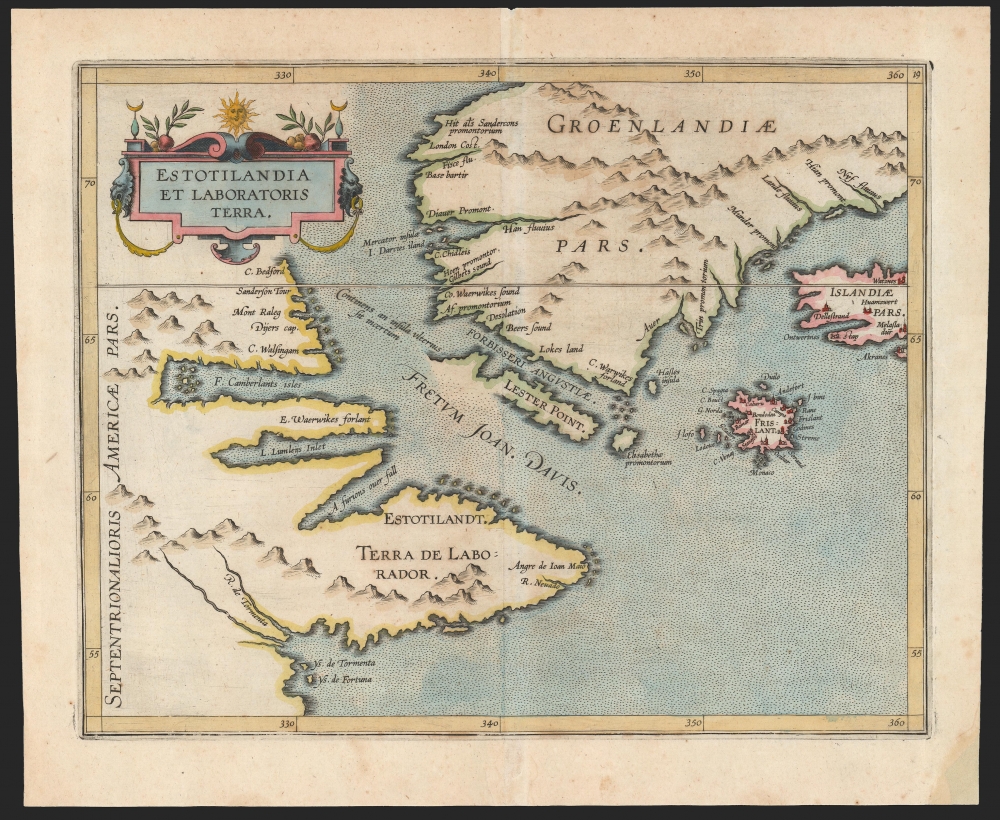
Estotilandia et Laboratoris Terra.
1597 (undated) 9.25 x 11.5 in (23.495 x 29.21 cm) 1 : 10500000
1597 (undated) 9.25 x 11.5 in (23.495 x 29.21 cm) 1 : 10500000
Description
This is Cornelis Wytfliet's 1597 map of Labrador and Greenland, combining the most up-to-date discoveries in the North Atlantic with one of the most fascinating cartographic frauds committed to print.
Along with Frisland, Estotiland first appeared on the 1558 Carta Da Navegar of Nicolo Zeno the Younger. That map appeared in Zeno's 'anonymous' pamphlet alleging the 14th-century Atlantic voyages of Zeno's ancestors Nicoló and Antonio Zeno. The map presented Estotiland as a partial coastline only, and the text of the pamphlet described Estotiland specifically as an island. It appeared at the western extreme of that map as a partial coastline, and was not definitively connected to any landmass. Although eventually exposed as a deliberate fraud, in his day Zeno the Younger’s deception was widely accepted - as evidenced by the present work. Indeed, Martin Frobisher himself (upon sighting the southern coast of Greenland in 1576) believed that he had seen Frisland and loyally claimed it for England. But Estotiland may have been a more important feature of Zeno's cartography than the flashier Frisland, since its presence at the west of the Atlantic implied a Venetian transatlantic voyage of exploration that significantly predated the 1492 voyage of Columbus. Interpreters of Zeno's geography - including Mercator and Ortelius - found that the coast of Estotiland corresponded well with Labrador, and it was thereafter assumed that Zeno's concocted Estotiland was part of Labrador.
A Closer Look
The map depicts the northwest extremes of the Atlantic, from the Canadian Labrador coast to Greenland. It is centered on the Davis Strait separating those two landmasses; to the east, the map includes the western parts of Iceland and Nicolo Zeno's fraudulent Frisland. The coastlines of Labrador and Greenland abutting on the Davis Strait present the discoveries of both Davis and Frobisher, including the 'furious over fall' which represents the first indication of Hudson Strait. The description of this passage is thought to have been one of the spurs to send Henry Hudson ( c. 1565 - disappeared June 23, 1611) on his fateful search for a Northwest Passage.The Source
Most of Wytfliet's maps are based on the 1592 Petrus Plancius Nova et Exacta Terrarum Orbis Tabula. This map, however, drawn on a more current course, the 1594 Cornelis Claesz Nova Francia, both in its presentation of the fraudulent cartography of Nicolo Zeno and its revelations of the exploration of both Frobisher and Davis. For the former, Wytfliet's map shows accepted canon: Zeno's cryptocartography was embraced by such luminaries as Mercator, Ortelius, and Plancius. Davis and Frobisher data, on the other hand, was first publihsed on the Claesz' map. According to Burden, there are only eight recorded examples of the Claesz map (we see only one in OCLC). Thus, the present Wytfliet is the earliest acquirable map to reveal Davis and Frobisher's discoveries.'What' and Labrador?
Despite its depiction of plenty of actual locations - Labrador, Greenland, Iceland, and Davis Strait, the map's title gave top billing to Estotiland: a place as imaginary as the phantom island Frisland, also present. Why its prominence?Along with Frisland, Estotiland first appeared on the 1558 Carta Da Navegar of Nicolo Zeno the Younger. That map appeared in Zeno's 'anonymous' pamphlet alleging the 14th-century Atlantic voyages of Zeno's ancestors Nicoló and Antonio Zeno. The map presented Estotiland as a partial coastline only, and the text of the pamphlet described Estotiland specifically as an island. It appeared at the western extreme of that map as a partial coastline, and was not definitively connected to any landmass. Although eventually exposed as a deliberate fraud, in his day Zeno the Younger’s deception was widely accepted - as evidenced by the present work. Indeed, Martin Frobisher himself (upon sighting the southern coast of Greenland in 1576) believed that he had seen Frisland and loyally claimed it for England. But Estotiland may have been a more important feature of Zeno's cartography than the flashier Frisland, since its presence at the west of the Atlantic implied a Venetian transatlantic voyage of exploration that significantly predated the 1492 voyage of Columbus. Interpreters of Zeno's geography - including Mercator and Ortelius - found that the coast of Estotiland corresponded well with Labrador, and it was thereafter assumed that Zeno's concocted Estotiland was part of Labrador.
Publication History and Census
This map was engraved in Louvain in 1597 for Cornelis Wytfliet's Descriptionis Ptolemaicae Augmentum, a work intended to focus on the parts of the world unknown to Ptolemy. After the 1597 first printing, six additional editions followed. There is only one known state. The present example exhibits a bold, dark image suggestive of an early strike. The map, in its various editions, is well represented in institutional collections.CartographerS
Cornelius van Wytfliet (1555 - 1597) was a Flemish cartographer and engraver active in the second half of the 16th century. Little unfortunately is known of Wytfliet's life or education. He seems to have been employed as secretary to the Council of Brabant, essentially the supreme court of the Duchy of Brabant. In cartographic circles Wytfliet is best known for his publication in 1597 of Descriptionis Ptolemaicae Augmentum, the first atlas dedicated exclusively to the America's. Wytfliet imaged the atlas as a supplement to classical Ptolemaic geographic, which traditionally accounted only for Europe, Africa, and Asia. The 19 maps contained within the Descriptionis Ptolemaicae Augmentum are some of the earliest specific maps detailed various parts of the Americas. More by this mapmaker...
Nicolò Zeno the Younger (1515–1565) was a Venetian Senator and author. He was the son of a literary man and a family powerful in Venetian politics, and was reputedly educated in science and the humanities. He was a successful hydraulic engineer, a most important field in so inundated a city as Venice. Able though he may have been, his early entrance to politics at the age of 23 was made possible via payments of 100 ducats to the Council of Ten. Following Venice's disastrous 1537-1540 war with the Ottoman Empire, Zeno wrote and published an unpublished history of the conflict notable for its invective against proponents of the war.
Zeno is mainly remembered for his 1558 publication of a map and series of letters which he claimed to have discovered in a storeroom of the family's home in Venice, purporting to describe a fourteenth century voyage by his ancestors, Nicolò and Antonio Zeno, to the north Atlantic and even to North America. Zeno's position as Senator would have discouraged question of his honesty in Venice, certainly, and the inclusion of his map in Ruscelli's successful 1561 edition of Ptolemy ensured the spread of his geographical ideas. And indeed, Zeno's map was widely accepted for over a century, influencing the maps of Ortelius, Mercator, Blaeu and others, until research (in particular that of Frederic W. Lucas, in 1898) identified both the cartographic and textual sources Zeno employed in concocting his report, demolishing its credibility. Learn More...
Source
Wytfliet, C., Descriptionis Ptolemaicae Augmentum sive Occidentis Notitia Brevi commentario illustrata Studio et opera Cornely Wytfliet Louaniensis, (Louvain) 1597.
Wytfliet's Descriptionis Ptolemaicae Augmentum, published in Louvain (Belgium) in 1597, is considered the first atlas specifically dedicated to the Americas. Classical geography, as defined by Claudius Ptolemy's Geographia, only accounted for a three part world - consisting of Asia, Europe, and Africa. The discovery of the Americas in 1492 threw a wrench into this well-established geographic system. Wytfliet imagined his work as a supplement to the Ptolemaic atlas. Drawn from earlier maps, as well as the texts of Acosta, Hakluyt, de Bry, and Ramusio, the Descriptionis Ptolemaicae Augmentum consisted of a history of New Work exploration illustrated by 19 unique maps of the American continent. Many of the individual maps are the first specific illustrations of their respective regions. The work proved popular and went through several editions. The first Latin edition, printed in Louvain, appeared in 1597. Two subsequent Latin ediitons were printed in 1598 and 1603. Further editions appeared in 1605, 1607, and 1611.
Condition
Very good. Marginal mend at bottom centerfold not impacting printed image.
References
OCLC 61510776. Rumsey 11622.064. Burden, P., The Mapping of North America, 101; Kershaw, K. A., Early Printed Maps of Canada Volume 1, #40.