This item has been sold, but you can get on the Waitlist to be notified if another example becomes available, or purchase a digital scan.
1787 Delamarche Map of the United States w/ Jeffersonian states and Indiana Company
EtatsUnis-delamarche-1787$900.00

Title
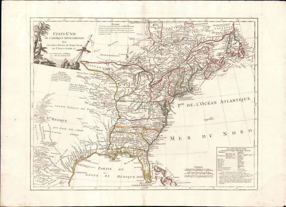
Etats-Unis de L'Amérique Septentrionale Avec Les Isles Royale, de Terre Neuve, de st. Jean, L'Acadie et c.
1787 (undated) 19.5 x 25.5 in (49.53 x 64.77 cm) 1 : 7500000
1787 (undated) 19.5 x 25.5 in (49.53 x 64.77 cm) 1 : 7500000
Description
An uncommon and important 1785 - 88 Charles Delamarche and Charles Dien map of the fledgling United States shortly after the American Revolutionary War. This map is important as the first to describe the 1784 Jeffersonian Ordinance, in doing so the first to apply the term Michigan to a land area, and for its detailed illustration of the new international borders ratified under the 1783 Treaty of Paris. It is also the first to show the mercantile concession 'Indiana' in the vicinity of modern-day West Virginia. Geographically the map covers from James Bay and Labrador to Florida and the Bahamas, as well as from the Rio de Norte (Rio Grande) to the Atlantic seaboard and Newfoundland.
The Philadelphia Company sent a large flotilla of goods down the Ohio River, where they were attacked and seized by a Shawnee raiding party near present day Wheeling, West Virginia. The goods were either seized or destroyed. At the time, the Shawnee were a tributary of the powerful Iroquois 'Six Nations' Confederacy, which were loosely allied with the English. The Philadelphia Company lodged a formal complaint with the Confederacy who agreed that, indeed, an injustice had been done and the Philadelphia Company deserved recompense. While powerful, the Iroquois were not wealthy as European's understood the term, and had no cash resources able to compensate the Company for the nearly half-million dollars (in modern terms) lost.
What they had was a lot of land. The Confederacy formed a land treaty with the English in 1768, and in that treaty set aside 5000 square miles of land to compensate the Philadelphia Company. The concession was formalized by a charter and a written agreement with the Iroquois. They were given a deed to most of what is today West Virginia, signed by the six chiefs of the confederacy, and witnessed by the Governor and Chief Justice of New Jersey, and by several other gentlemen, representing Connecticut, Pennsylvania, Virginia, New York, and the English Crown.
The Philadelphia Company named their new colony after the people from whom they acquired the land - thus Indiana. In 1776, with the outbreak of the American Revolutionary War, these lands were transferred to a new company, the Indiana Land Company, who planned to sell it off in lots. The transaction drew the attention of the governors of Virginia, who claimed the land under their own royal charter. The parties argued the matter throughout the War and afterwards the Indiana Land Company made a direct appeal to the Continental Congress. This failed, but with the ratification of the Constitution and the establishment of the Supreme Court, the Company brought a formal lawsuit against Virginia. Virginia, believing its state's rights imputed, refused to appear, and instead pursued an amendment to the Constitution protecting its rights. This became the 11th Amendment, the first to follow the Bill of Rights, giving individual states sovereign immunity against suit from other states, countries, or individuals. With this amendment ratified in 1797, the Indiana Land Company lost all claim on the land and fell into insolvency. Thus, a portion of Virginia roughly equivalent to West Virginia, named Indiana, appeared on maps from about 1768 to 1798.
1783 Treaty of Paris Borders
This map is also significant in its illustration of the new boundaries accorded to the freshly minted United States under the 1783 Treaty of Paris. The United States is outlined in green, British territories appear in red, and Spanish lands in yellow. The United States extends westward to the Mississippi, beyond which Louisiana has been granted to Spain. So too has Florida and the French colonial seat of New Orleans. The British have retained Canada, with the northern border extending through the Lake of the Woods (L. des Bois), Lake Superior, Lake Huron, Lake Erie, and Lake Ontario - much as it remains to this day. There is some confusion regarding the Maine / Sagadahoc border where Sagadahoc (Sagadahok) is granted to the United States, but Maine given to Canada. Since both Maine and Sagadahok were administered by the Massachusetts Bay colony, as noted in the table, this cartographic oddity remains a mystery.The First Indiana
Note the area of modern-day West Virginia - here ephemerally identified as 'Indiana'. This is an ephemeral merchant colony that existed from 1768 to 1798 and represent the first use of the name Indiana. The French and Indian War (1754 - 1763) forced the French out of North America, creating an expansive power vacuum that stretched from the Mississippi River to the Appalachian Mountains. Recognizing the economic potential of the region, a company of 25 Philadelphia merchants headed by George Morgan (1743 - 1810) formed the Philadelphia Company, with the mission to monopolize the Ohio Valley Indian trade.The Philadelphia Company sent a large flotilla of goods down the Ohio River, where they were attacked and seized by a Shawnee raiding party near present day Wheeling, West Virginia. The goods were either seized or destroyed. At the time, the Shawnee were a tributary of the powerful Iroquois 'Six Nations' Confederacy, which were loosely allied with the English. The Philadelphia Company lodged a formal complaint with the Confederacy who agreed that, indeed, an injustice had been done and the Philadelphia Company deserved recompense. While powerful, the Iroquois were not wealthy as European's understood the term, and had no cash resources able to compensate the Company for the nearly half-million dollars (in modern terms) lost.
What they had was a lot of land. The Confederacy formed a land treaty with the English in 1768, and in that treaty set aside 5000 square miles of land to compensate the Philadelphia Company. The concession was formalized by a charter and a written agreement with the Iroquois. They were given a deed to most of what is today West Virginia, signed by the six chiefs of the confederacy, and witnessed by the Governor and Chief Justice of New Jersey, and by several other gentlemen, representing Connecticut, Pennsylvania, Virginia, New York, and the English Crown.
The Philadelphia Company named their new colony after the people from whom they acquired the land - thus Indiana. In 1776, with the outbreak of the American Revolutionary War, these lands were transferred to a new company, the Indiana Land Company, who planned to sell it off in lots. The transaction drew the attention of the governors of Virginia, who claimed the land under their own royal charter. The parties argued the matter throughout the War and afterwards the Indiana Land Company made a direct appeal to the Continental Congress. This failed, but with the ratification of the Constitution and the establishment of the Supreme Court, the Company brought a formal lawsuit against Virginia. Virginia, believing its state's rights imputed, refused to appear, and instead pursued an amendment to the Constitution protecting its rights. This became the 11th Amendment, the first to follow the Bill of Rights, giving individual states sovereign immunity against suit from other states, countries, or individuals. With this amendment ratified in 1797, the Indiana Land Company lost all claim on the land and fell into insolvency. Thus, a portion of Virginia roughly equivalent to West Virginia, named Indiana, appeared on maps from about 1768 to 1798.
Jeffersonian Ordinance
One of this map's most historically significant features is its inclusion of a table in the lower right quadrant detailing the proposed states of the Jeffersonian Ordinance of 1784 - the first map to do so. Delamarche, being a known correspondent of Jefferson, must have attained this information well in advance of competing cartographers and considered it something of a coup. The Ordinance of 1784 was a recommended plan for dealing with the new territory officially accorded to the United States by the 1783 Treaty of Paris, which formally ended the American Revolutionary War (1771 - 1783). The treaty ceded to the United States all former British territory east of the Mississippi and south of the Great Lakes. Jefferson proposed, rather than follow old colonial boundaries, that all territory west of Appalachian Mountains be federally administered, surveyed, and broken up into various states - for which he seems to have provided a list of rather arbitrary names. The intent of the Ordinance was to lay the groundwork for settlement and eventual statehood. The list of suggested Jeffersonian territories, appearing on the lower right, included Silvania, Michigania, Chersenosus, Arsenistpia, Metropotamia, Illinoia, Saratoga, Washington, Polypotamia, and Pelisypia. Few of these names survived but Michigania, Washington, and Illianoia stand out as exceptions. Although the term 'Illinois' was already in common usage, this is very notably the first cartographic use of 'Michigan' in reference to a land area. Washington would not emerge as a new territory until much later and far beyond the United States as anticipated by Jefferson. Ultimately the Jefferson Ordinance was only partially adopted, but it influenced the Northwest Ordinance of 1787 and ultimately the creation of the Federal Land Survey.Spanish Louisiana
At the end of the French and Indian War (1755 - 1763), the Treaty of Fontainebleau (1762) granted all of the lands west of the Mississippi to Spain - creating Spanish Louisiana (1762 - 1801). Nearly 1/3rd of the map is given to the Spanish territories between the Mississippi and the Rio Grande. As the map notes, this was a 'Grand Espace de Pays Qui N'est Pas Connu' (Great Tract of Country which is not known). Nonetheless, several tribes are noted, including the Sioux, Apache, and Padouca, among others. In modern-day Texas, here identified as Tecas, the old Spanish missions along the Rio de Norte (Rio Grande), including Santa Fe, are noted. One might wonder why a map intent on illustrating the United States would include these vast Spanish territories. Most likely this is a response to Delamarche catering to his French clientele who would have retained a significant interest in those former French Territories, including Quebec and Louisiana, lost during the French and Indian War.Publication History and Census
This map makes its first appearance 1785. It is either one of Robert de Vaugondy's final works - he died in 1786 - or it is the work of Jean-Baptiste Fortin, or Charles-François Delamarche (1740 - 1817). The first edition bears the imprint of Antoine Boudet (Chés Boudet), Vaugondy's long-time publishing partner, noting it is for the 'Supplement a l'Atlas de M. Robert de Vaugondi.' We note a near-identical edition, also dated 1785, bearing the Delmarche imprint. The present edition bears the Charles Dien imprint as well. This can only be Charles Dien Sr., who engraved for Delamarche, as the younger more famous globe-maker Dien had not yet been born! Nonetheless, the light impression on the cartouche and the address Jardinet no 13, suggests a slightly later printing, perhaps 1787 - 1788. This map makes occasional market appearances, but we see no other examples with the Dien imprint.CartographerS
Charles-François Delamarche (August 1740 - October 31, 1817) founded the important and prolific Paris-based Maison Delamarche map publishing firm in the late 18th century. A lawyer by trade, Delamarche entered the map business with the 1787 acquisition from Jean-Baptiste Fortin of Robert de Vaugondy's map plates and copyrights. Delamarche appears to have been of dubious moral character. In 1795, the widow of Didier Robert de Vaugondy, Marie Louise Rosalie Dangy, petitioned a public committee for 1500 livres, which should have been awarded to her deceased husband. However, Delamarche, proclaiming himself Vaugondy's heir, filed a simultaneous petition and walked away with the funds, most of which he was instructed to distribute to Robert de Vaugondy's widow and children. Just a few months later, however, Delamarche proclaimed Marie Dangy deceased, and it is highly unlikely that any funds found their way to Robert de Vaugondy's impoverished daughters. Nonetheless, where Robert de Vaugondy could barely make ends meet as a geographer, Delamarche prospered as a map publisher, acquiring most of the work of earlier generation cartographers Lattre, Bonne, Desnos, and Janvier, thus expanding significantly upon the Robert de Vaugondy stock. Charles Delamarche eventually passed control of the firm to his son Felix Delamarche (c. 1750 - c. 1850) and geographer Charles Dien (1809 - 1870). It was later passed on to Alexandre Delamarche, who revised and reissued several Delamarche publications in the mid-19th century. The firm continued to publish maps and globes until the middle part of the 19th century. More by this mapmaker...
Charles Dien Sr. (17xx - 18xx) was a French engraver and map publisher. Dien worked extensively with Charles-François Delamarche (1740 - 1817). His son, Charles Dien Jr. (February 9, 1800 - 1870), was a prominent globe maker who himself worked closely with C. F. Delamarche's son, Félix Delamarche. Learn More...
Condition
Very good. Original centerfold. Minor water stain lower right margin.
References
Karpinski, L. C., Bibliography of the Printed Maps of Michigan, 1804-1880, #CIII. Sellers, John R. and Van Ee, Patricia, Maps and Charts of North America, no. 187. Mapforum, Early Maps of the United States, 67. McCorkle, B. B, New England in Early Printed Maps 1513 - 1800, 785.5. Pedley, M. A., Bel et Utile: The Work of the Robert de Vaugondy Family of Mapmakers, p. 227.