This item has been sold, but you can get on the Waitlist to be notified if another example becomes available, or purchase a digital scan.
1935 Melantrich Czech Map of Eithiopa illustrating the Second Italo-Abyssinian War
Ethiopia-Melantrich-1935$400.00

Title
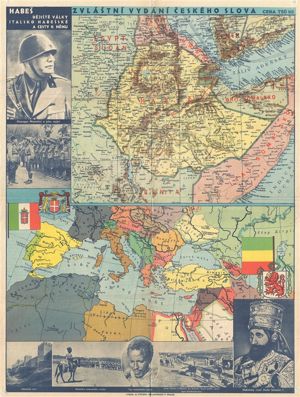
Zvláštní vydání Českého slova / Habeš dějiště války Italsko-Habešské a cesty k němu. / Special Edition of the Czech Word. Abyssina: The Theater of War in Italo-Abyssinia and the Way There.
1935 (undated) 24 x 18 in (60.96 x 45.72 cm)
1935 (undated) 24 x 18 in (60.96 x 45.72 cm)
Description
An unusual 1935 Czech issue pictorial map illustrating the theater of the Second Italo-Abyssinian War (1935-1936). This informational map appears in two parts, the upper part offers a detailed map of what is essentially Modern day Ethiopia, bordered by Eritrea, French Somalia, British Somalia, and Italian Somalia. Kenya is to the south and Egypt/Sudan appears to the west. Below this map there is another large map illustrating the general political situation in southern Europe.
In October of 1935 Benito Mussolini (upper left), counting on the lethargy of the League of Nations, invaded Ethiopia, then under the leadership of the Emperor Halie Selassie (lower right). The map contrasts images of Mussolini and the modern Italian army in the upper left with Halie Selassie, the Habesha people, and an Ethiopian fortress, along the bottom of the map. The comparatively mediaeval state of military readiness in Ethiopia gives little doubt as to the outcome of the war which after several months of conflict resulted in the military occupation of Ethiopia.
This map was issued by Melantrich, a Czech publisher aligned with the Czech National Social Party. All text is in Czech. It is extremely rare, with the OCLC identifying no known examples in any public collection.
Cartographer
Nakladatelství Melantrich (1897 - 1999) was a large Czech publishing house active in Prague throughout the 20th century. Melantrich, original called, Nihtiskárna národně sociálního dělnictva (Printing press of national socialist workers) was established as a press front for the Czech National Social Party (no relation to German National Socialism) in 1897. In 1907, under Jaroslav Šalda (1880–1965), the publishing firm began publishing the daily newspaper České slovo (The Czech Word). The paper proved popular and led to a period of expansion for the paper. Around this time they also adopted the name Melantrich, after the renaissance painter Jiří Melantrich of Aventino (1511-1580). In 1924 the firm expanded again and was reorganized as a joint stock company. The influx of capital enabled Melantrich to acquire several competing presses and expand to other cities. Under Šalda the publishing house continued to grow becoming the largest publisher in the First Republic of Czechoslovakia. Šalda was imprisoned during the Nazi Occupation (1938–1945) and the paper fell under the control of Nazi collaborators. When the Communists took over the country in 1948 Šalda was removed, the company nationalized, and split into three parts. In 1950 the publishing house changed its name to Svobodné slovo-Melantrich, in 1960 to Svobodné slovo and again in 1967 back to Melantrich. It was acquired by Chemapol in 1996. Chemapol itself filed for bankruptcy in 1998. Unable to compete, they ceased operations in 1999. More by this mapmaker...
Condition
Good. Some wear on original fold lines Pin holes in all four corners. Minor verso reinforcement.
References
OCLC 320568347.