This item has been sold, but you can get on the Waitlist to be notified if another example becomes available.
1955 Highway Map of Ethiopia
EthiopiaHighwayMap-unknown-1955$200.00


Title
Highway Map of Ethiopia.
1955 (undated) 32.5 x 33.5 in (82.55 x 85.09 cm) 1 : 2000000
1955 (undated) 32.5 x 33.5 in (82.55 x 85.09 cm) 1 : 2000000
Description
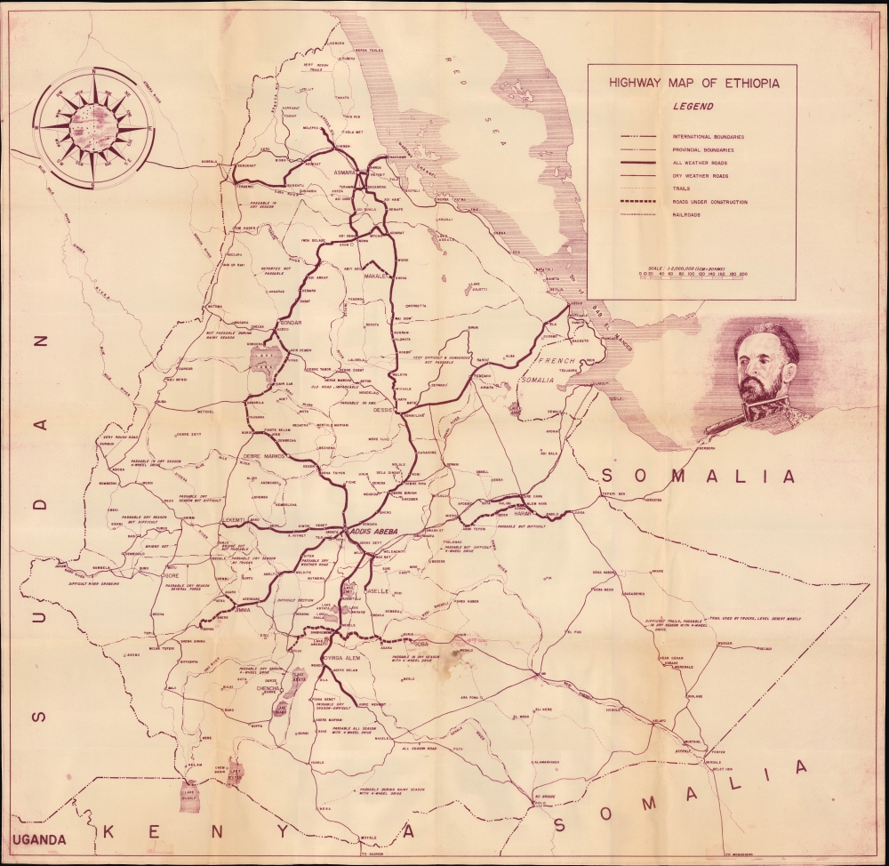
This is a c. 1955 highway map of Ethiopia, most likely produced by the country's Imperial Highway Authority. At the time, Ethiopia was undergoing a breakneck modernization push, championed by Emperor Haile Selassie (r. 1930 - 1974).
To facilitate his efforts, Haile Selassie pursued improved infrastructure, including highways, and capitalized on his international stature to gain foreign assistance. In particular, the United States provided technical assistance from the U.S. Bureau of Public Roads through the Point Four Program, an early Cold War foreign aid program established by President Truman. The Imperial Highway Authority was established in 1951. Later, funds for Ethiopian highways were supplied by the World Bank. It is notable and telling that this map is in English, though it is likely an Amharic equivalent was produced.
Prior to the Italian occupation, the country's only all-weather road was the 58-kilometer link between Addis Ababa and Addis Alem. During the Italian occupation, some 7000 kilometers of roads were built, more than half of which were tarred, including a highway between Asmara and Addis Ababa, one of the few benefits of their presence in Ethiopia. After the war, and particularly after the establishment of the Imperial Highway Authority and the infusion of foreign aid, hundreds of kilometers of highways and improved roads were added annually.
A Closer Look
Coverage embraces the Ethiopian Empire, including Eritrea, which was in an increasingly close federation with Ethiopia at the time, resulting in its annexation by Ethiopia in 1962. International and provincial boundaries, cities, towns, waterways, railroads, roads of various types and qualities, and roads under construction are indicated. Notes about the condition of roads appear throughout, explaining that, in many areas, 4-wheel drive will be required, and even then, may only be passable in the dry season.The Road(s) to Modernity
Emperor Haile Selassie (depicted in a portrait at right here) came into power in 1930 with the aim of reforming and modernizing Ethiopia, but was quickly distracted by a confrontation with Fascist Italy, which harbored clear designs on his country. After leading a heroic defense of Ethiopia in the Second Italo-Abyssinian War (1935 - 1937), Haile Selassie was forced into exile in Britain, but returned to Addis Ababa in May 1941, an early victory for the Allies in World War II (1939 - 1945). He quickly returned to his modernization plans, but faced significant obstacles from nobles and clergy deeply rooted in the provinces and resistant to centralization.To facilitate his efforts, Haile Selassie pursued improved infrastructure, including highways, and capitalized on his international stature to gain foreign assistance. In particular, the United States provided technical assistance from the U.S. Bureau of Public Roads through the Point Four Program, an early Cold War foreign aid program established by President Truman. The Imperial Highway Authority was established in 1951. Later, funds for Ethiopian highways were supplied by the World Bank. It is notable and telling that this map is in English, though it is likely an Amharic equivalent was produced.
Prior to the Italian occupation, the country's only all-weather road was the 58-kilometer link between Addis Ababa and Addis Alem. During the Italian occupation, some 7000 kilometers of roads were built, more than half of which were tarred, including a highway between Asmara and Addis Ababa, one of the few benefits of their presence in Ethiopia. After the war, and particularly after the establishment of the Imperial Highway Authority and the infusion of foreign aid, hundreds of kilometers of highways and improved roads were added annually.
Publication History and Census
This map contains no publication information, but it was most likely produced in the 1950s by the Ethiopian Imperial Highway Authority. It stylistically matches later maps put out by that body. Although several listings appear in the OCLC with this title, none seem to perfectly correspond to the present map. The closest match is a map held by the American University of Beirut (OCLC 786929143), which mentions verso illustrations lacking here.Condition
Very good. Light wear along original fold lines. Closed edge tears professionally repaired on verso.
References
Baker, J., 'Developments in Ethiopia's Road System' Geography, Vol. 59, No. 2, (April 1974), pp. 150-154.