This item has been sold, but you can get on the Waitlist to be notified if another example becomes available, or purchase a digital scan.
1707 J. B. Homann Europe, with the Eclipse of 1706
Europe-homann-1707$375.00

Title
Europa Christiani Orbis Domina in sua Imperia, Regna, et Status exacte divisa per Johan Bapt. Homann Norimbergae.
1707 (undated) 19.25 x 22.75 in (48.895 x 57.785 cm) 1 : 10000000
1707 (undated) 19.25 x 22.75 in (48.895 x 57.785 cm) 1 : 10000000
Description
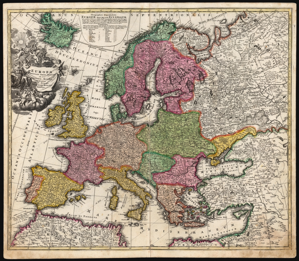
This is a scarce early example of Johann Baptist Homann's 1707 map of Europe presenting, in collaboration with mathematician J. Gabriel Doppelmayr, the progress of the May 12, 1706 eclipse of the sun.
The second cartouche, a banner cast across the sea between Iceland and Scandinavia, is by contrast a hasty affair. It is less realistically rendered and its focus is entirely upon the eclipse: Geographical Representation of Europe Eclipsed on the 12th Map of 1706. This secondary cartouche is mainly focused on noting the greatest visibility of the Eclipse recorded at specific European cities.
Subsequent to the publication of this map, in 1715 or later, Amsterdam publisher Peter Schenk an embellished edition of the map which included subordinate maps depicting the eclipse of May 3, 1715.
A Closer Look
The map presents Europe from Iceland and the British Isles to the shores of the Caspian Sea. It spans from Scandinavia in the north to the upper limits of Africa and the Levant in the south. Employing parallel concentric arcs, the map shows the parts of Europe from which the 1706 eclipse was visible, noting in particular the central zone of the eclipse from which the total eclipse had been witnessed: this spanned from Gibraltar across the Mediterranean coasts of Spain and France, Savoy, Switzerland, Germany, Prussia, Livonia and the Swedish frontier with Russia.Allegorical Engraving
The cartouche, set about one of the two titles assigned this map, is a beautiful example of baroque decoration. It is on the theme of that title, which translates roughly to 'Europe, (ruling) Lady of the Christian World, exactly divided into its Empires, Kingdoms, and States by Johann Bapt. Homann.' The titular woman is pictured seated next to the title, her left hand rested upon it, a laurel on her brow and a sword at rest on her right shoulder. A riot of putti attend her: two of the pudgy cherubs seated on the cloud at her feet offer her up the crowns of Europe and the east; two helpfully support the title banner itself. Four bear symbols of religious authority: a crucifix, bishops' croziers, a chalice and host, and the papal crown. Yet another kneels in worship of a triangular representation of the Trinity, radiant in the clouds.The second cartouche, a banner cast across the sea between Iceland and Scandinavia, is by contrast a hasty affair. It is less realistically rendered and its focus is entirely upon the eclipse: Geographical Representation of Europe Eclipsed on the 12th Map of 1706. This secondary cartouche is mainly focused on noting the greatest visibility of the Eclipse recorded at specific European cities.
Earlier States
The two cartouches hint about a truth: the map was first engraved before the eclipse, and Doppelmayr's information was added. There exist two extremely rare pre-atlas editions of this map: one, Homann's Europa Christiani Orbis Domina, was executed between 1702 and 1705 and would have been his planned Europe map for the atlas; we see an example described in the Sachsische Landesbibliothek, although not pictured. A version of the map exists without the secondary 'eclipse' cartouche but with its text added in an appended plate in the upper margin. The main, decorative cartouche can only be described as unfinished: the fine features of Europa's face are not yet composed. The suggestion is that the work in progress had Doppelmayr's eclipse details added shortly after the event, to offer the map as a separate issue prior to the publication of the Homann Neuer Atlas. This stopgap completed, Homann was able at leisure to complete the composition resulting in the work exhibited here.Subsequent to the publication of this map, in 1715 or later, Amsterdam publisher Peter Schenk an embellished edition of the map which included subordinate maps depicting the eclipse of May 3, 1715.
Publication History and Census
This is the first plate of this map, engraved for Johann Baptist Homann for inclusion in his planned atlas Neuer Atlas. The first version, engraved prior to 1706, lacked the eclipse detail. A second state of this included the eclipse data but lacked the relevant secondary cartouche. Both of the first two states are extremely rare. This example is a likely third state of the first plate. We see at least two further states prior to 1716; a later plate exists with Johnann Christian's privilege, probably dating to 1726. The present example is from a 1710 edition of the Neuer Atlas. In its many editions, the map is well represented in institutional collections and versions of the map appear on the market, but there is no complete census of individual states and plates, so the dating of these pieces is difficult to determine without examination of the maps themselves.CartographerS
Johann Baptist Homann (March 20, 1664 - July 1, 1724) was the most prominent and prolific map publisher of the 18th century. Homann was born in Oberkammlach, a small town near Kammlach, Bavaria, Germany. As a young man, Homann studied in a Jesuit school and nursed ambitions of becoming a Dominican priest. Nonetheless, he converted to Protestantism in 1687, when he was 23. It is not clear where he mastered engraving, but we believe it may have been in Amsterdam. Homann's earliest work we have identified is about 1689, and already exhibits a high degree of mastery. Around 1691, Homann moved to Nuremberg and registered as a notary. By this time, he was already making maps, and very good ones at that. He produced a map of the environs of Nürnberg in 1691/92, which suggests he was already a master engraver. Around 1693, Homann briefly relocated to Vienna, where he lived and studied printing and copper plate engraving until 1695. Until 1702, he worked in Nuremberg in the map trade under Jacob von Sandrart (1630 - 1708) and then David Funck (1642 - 1709). Afterward, he returned to Nuremberg, where, in 1702, he founded the commercial publishing firm that would bear his name. In the next five years, Homann produced hundreds of maps and developed a distinctive style characterized by heavy, detailed engraving, elaborate allegorical cartouche work, and vivid hand color. Due to the lower cost of printing in Germany, the Homann firm could undercut the dominant French and Dutch publishing houses while matching their diversity and quality. Despite copious output, Homann did not release his first major atlas until the 33-map Neuer Atlas of 1707, followed by a 60-map edition of 1710. By 1715, Homann's rising star caught the attention of the Holy Roman Emperor Charles VI, who appointed him Imperial Cartographer. In the same year, he was also appointed a member of the Royal Academy of Sciences in Berlin. Homann's prestigious title came with several significant advantages, including access to the most up-to-date cartographic information as well as the 'Privilege'. The Privilege was a type of early copyright offered to very few by the Holy Roman Emperor. Though less sophisticated than modern copyright legislation, the Privilege offered limited protection for several years. Most all J. B. Homann maps printed between 1715 and 1730 bear the inscription 'Cum Priviligio' or some variation. Following Homann's death in 1724, the firm's map plates and management passed to his son, Johann Christoph Homann (1703 - 1730). J. C. Homann, perhaps realizing that he would not long survive his father, stipulated in his will that the company would be inherited by his two head managers, Johann Georg Ebersberger (1695 - 1760) and Johann Michael Franz (1700 - 1761), and that it would publish only under the name 'Homann Heirs'. This designation, in various forms (Homannsche Heirs, Heritiers de Homann, Lat Homannianos Herod, Homannschen Erben, etc.) appears on maps from about 1731 onwards. The firm continued to publish maps in ever-diminishing quantities until the death of its last owner, Christoph Franz Fembo (1781 - 1848). More by this mapmaker...
Johann Gabriel Doppelmayr (September 27, 1677 - December 1, 1750) was a German mathematician and astronomer active in the first half of the 18th century. Doppelmayr was born in Nuremberg to a merchant family. He attended the Aegidien-Gymnasium and the University of Altdorf where he studied mathematics, physics, and law. His graduating dissertation, a study of the Sun, suggests an early interest in Astronomy. Following his studies in Altdorf, Doppelmayr traveled extensively in Europe and is known to have spent time at the University of Halle, as well as in Utrecht, Leiden, Oxford, and London. He returned to Nuremburg in 1704 to take up a mathematics professorship at his alma mater, the Aegidien-Gymnasium. It may have been here that he developed a relationship with the prominent Nuremburg map publisher J. B. Homann, with whom he prepared a number of important astronomical maps and atlases. The collaboration of over 20 years eventually led to the publication of the Atlas Novus Coelestis in 1742. This astounding work was the most elaborate and detailed astronomical atlas yet published and is today much admired for its rich beautifully engraved plates. Doppelmayr died on 1 December 1750 in Nuremberg, and many later sources claim that his death was caused by the fatal effects of a powerful electrical shock which he had received shortly before while experimenting with a battery of electric capacitors. Other sources, however, suggest that Doppelmayr's electrical experiments were performed several years earlier and were not the cause of his death. Today the Lunar crater Doppelmayr and a minor planetoid are named in his honor. Learn More...
Source
Homann, J. B., Neuer Atlas bestehend in einig curieusen Astronomischen Kuppren und vielen auserlesenen accuratensten Land-Charten über die Gantze Welt, (Nuremberg: Homann), 1710.
Homann's Neuer Atlas bestehend in einig curieusen Astronomischen Kuppren und vielen auserlesenen accuratensten Land-Charten über die Gantze Welt was first publihsed in 1707 with 33 maps. A second edition followed in 1710 with 60 maps. Subsequent editions followed until about 1730. The title page notes proudly that the atlas features measurements based on the 'Copernican principle of the moving sky', a truly state-of-the-art innovation for the period. Regardless of editions, collations of the atlas are inconsistent, with some examples having less, while others have more maps - a consequence of the fact that the map sheets were delivered loose, to be bound at the buyer's discretion, and so some buyers chose to omit maps they did not consider relevant, or add others they did. Between editions, the constituent maps, particularly of European regions, were regularly updated to reflect the most recent political events. The atlas continued to be published by Homann's son, J. C. Homann (1703 - 1730), and then by Homann Heirs. Most examples also feature a fine allegorical frontispiece with the title Atlas Novus Terrarum Orbis Imperia, regna et Status, which was used for multiple Homann atlases, including the Neuer Atlas and the Atlas Minor.
Condition
Good. Old mounting on thick paper for binding; attractive original hand color. Centerfold expertly mended with slight scuffing; marginal soling; else very good.
References
OCLC 835120490. Rumsey 12499.065 (1716 state).