This item has been sold, but you can get on the Waitlist to be notified if another example becomes available, or purchase a digital scan.
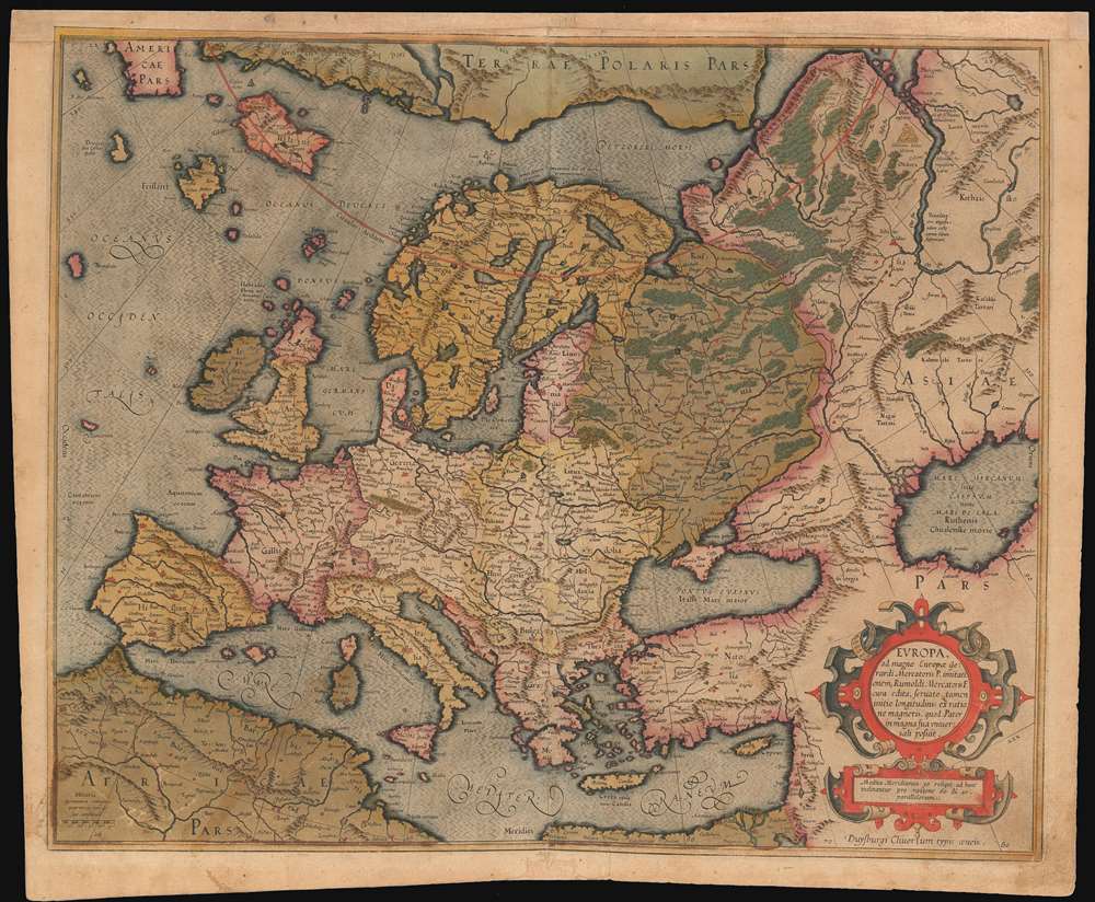
1595 Mercator Map of Europe
Europe-mercator-1595$425.00

Title
Europa, ad magnae Europae Gerardi Mercatoris P. imitationem, Rumoldi Mercatoris F. cura edita, servato tamen initio longitudinis ex ratione magnetis, quod Pater in magna sua universali posuit.
1595 (undated) 15.25 x 18.5 in (38.735 x 46.99 cm)
1595 (undated) 15.25 x 18.5 in (38.735 x 46.99 cm)
Description
The 1595 first atlas issue of Mercator's general map of Europe. It appeared in his Atlas Sive Cosmographia, published in Duisberg. The map's geography is drawn from Mercator's wall map - likely not his lost 1554 Europe, but his 1569 World map. This map includes the fictitious geographical information published by the Venetian Nicolo Zeno in 1558. Zeno claimed that two early 15th century noblemen in his family - Nicolò and Antonio - had discovered America prior to Columbus, and moreover had been stranded on an island called Frisland - an island that does not exist. The younger Zeno produced a map describing these spurious discoveries, and this map was accepted and reproduced by Mercator, and then by other cartographers swayed by that great cartographer's authority. Frisland appears here in sharper detail than does Iceland.
The map's meticulous lettering and beautiful engraving - particularly in the ocean areas and mountains - is typical of Mercator's maps. The map is embellished with an elegant strapwork cartouche. The map was substantially revised when the atlas' production was taken over by Jodocus Hondius in 1606: issues prior to Hondius are scarce on the market.
The map's meticulous lettering and beautiful engraving - particularly in the ocean areas and mountains - is typical of Mercator's maps. The map is embellished with an elegant strapwork cartouche. The map was substantially revised when the atlas' production was taken over by Jodocus Hondius in 1606: issues prior to Hondius are scarce on the market.
Cartographer
Gerard Mercator (March 5, 1512 - December 2, 1594) is a seminal figure in the history of cartography. Mercator was born near Antwerp as Gerard de Cremere in Rupelmonde. He studied Latin, mathematics, and religion in Rupelmonde before his Uncle, Gisbert, a priest, arranged for him to be sent to Hertogenbosch to study under the Brothers of the Common Life. There he was taught by the celebrated Dutch humanist Georgius Macropedius (Joris van Lanckvelt; April 1487 - July 1558). It was there that he changed him name, adapting the Latin term for 'Merchant', that is 'Mercator'. He went on to study at the University of Louvain. After some time, he left Louvain to travel extensively, but returned in 1534 to study mathematics under Gemma Frisius (1508 - 1555). He produced his first world map in 1538 - notable as being the first to represent North America stretching from the Arctic to the southern polar regions. This impressive work earned him the patronage of the Emperor Charles V, for whom along with Van der Heyden and Gemma Frisius, he constructed a terrestrial globe. He then produced an important 1541 globe - the first to offer rhumb lines. Despite growing fame and imperial patronage, Mercator was accused of heresy and in 1552. His accusations were partially due to his Protestant faith, and partly due to his travels, which aroused suspicion. After being released from prison with the support of the University of Louvain, he resumed his cartographic work. It was during this period that he became a close fried to English polymath John Dee (1527 - 1609), who arrived in Louvain in 1548, and with whom Mercator maintained a lifelong correspondence. In 1552, Mercator set himself up as a cartographer in Duisburg and began work on his revised edition of Ptolemy's Geographia. He also taught mathematics in Duisburg from 1559 to 1562. In 1564, he became the Court Cosmographer to Duke Wilhelm of Cleve. During this period, he began to perfect the novel projection for which he is best remembered. The 'Mercator Projection' was first used in 1569 for a massive world map on 18 sheets. On May 5, 1590 Mercator had a stroke which left him paralyzed on his left side. He slowly recovered but suffered frustration at his inability to continue making maps. By 1592, he recovered enough that he was able to work again but by that time he was losing his vision. He had a second stroke near the end of 1593, after which he briefly lost speech. He recovered some power of speech before a third stroke marked his end. Following Mercator's death his descendants, particularly his youngest son Rumold (1541 - December 31, 1599) completed many of his maps and in 1595, published his Atlas. Nonetheless, lacking their father's drive and genius, the firm but languished under heavy competition from Abraham Ortelius. It was not until Mercator's plates were purchased and republished (Mercator / Hondius) by Henricus Hondius II (1597 - 1651) and Jan Jansson (1588 - 1664) that his position as the preeminent cartographer of the age was re-established. More by this mapmaker...
Source
Mercator, G. Atlas, sive Cosmographicæ meditationes de fabrica mundi et fabricati figura. Duisberg, 1595
Condition
Good. Centerfold reinforced with some loss. Upper margin extended with some manuscript reinstatement of border.
References
OCLC 633411868. Van der Krogt 1000:1A.