This item has been sold, but you can get on the Waitlist to be notified if another example becomes available, or purchase a digital scan.
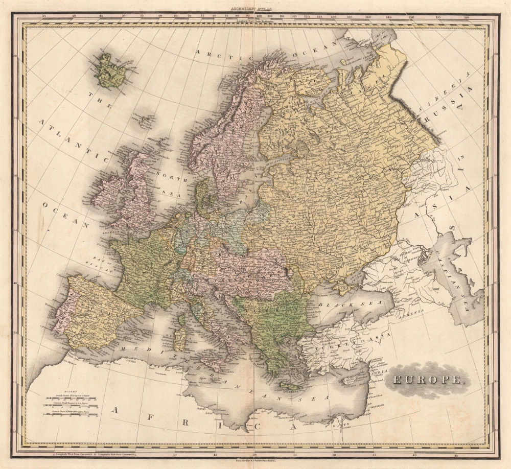
1825 Tanner Map of Europe
Europe-tanner-1825$162.50

Title
Europe.
1825 (undated) 20 x 21 in (50.8 x 53.34 cm) 1 : 11404800
1825 (undated) 20 x 21 in (50.8 x 53.34 cm) 1 : 11404800
Description
This is Henry Schenck Tanner's impressive 1825 map of Europe. Depicting the entirety of the continent, the finely engraved image unveils Europe as it coalesced roughly 10 years after the Napoleonic Wars. Finland and the eastern part of Poland have been absorbed into a sprawling Russian Empire. Ottoman influence extends to Wallachia and western Moldavia. Italy has yet to begin its struggle for national solidarity and remains divided into small kingdoms and city-states. Germany remains divided into kingdoms and principalities as well, with its unification still decades in the future.
Publication History
This map was created and published by H.S. Tanner for inclusion in his New American Atlas. The present example is from the scarce 1825 2nd edition of Tanner's iconic New American Atlas.Cartographer
Henry Schenck Tanner (1786 - May 18, 1858) was one of the preeminent American map engravers and publishers of the early 19th century - what is considered to be the "Golden Age of American Map Publishing". Born in New York City but based in Philadelphia, Tanner's forty plus year career was almost entirely focused on cartographic work. His earliest map work appears in conjunction with another important map publisher, John Melish. Early in his career, Tanner partnered with his brother Benjamin, to engrave extensively for Melish as well as other Philadelphia publishers including Lucas Fielding (Baltimore), A. Bourne, Jason Torey, Samuel Harrison, and Samuel Lewis, among others. In 1818 Tanner convinced his fellow publishers and partners to finance the compilation of a New American Atlas. The atlas was sold by subscription and slowly emerged between 1819 and 1823. The New American Atlas, possibly the pinnacle of 19th century American cartography and was commended in its day as "one of the most splendid works of the kind ever executed in this country". It was subsequently republished in several updated editions until about 1839. Tanner had by this time become the most active and influential map publisher in the United States. Around 1832, recognizing the market for a less cost prohibitive atlas, Tanner began work on the smaller format New Universal Atlas. This popular and important atlas went through numerous editions before being bought out by Carey and Hart, and then, in 1846, by S. A. Mitchell, who would rise to become the preeminent publisher of the next generation. In addition to these important atlases, Tanner also issued numerous extremely important and influential travelers guides, state maps, wall maps, and pocket maps. He should not be confused with his brother, also an America map engraver, the New Yorker Benjamin Tanner. More by this mapmaker...
Source
Tanner, H. S., A New American Atlas, (Philadelphia: Tanner) 1825.
Condition
Good. Some old printer creases in the upper right. Wear to original centerfold and is reinforced on the verso.
References
Rumsey 2755.002.