This item has been sold, but you can get on the Waitlist to be notified if another example becomes available, or purchase a digital scan.
1652 Jansson Map of Europe in Antiquity
EuropeAncient-jansson-1652$200.00

Title
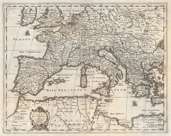
Lumen Historiarum per Occidentem.
1652 (undated) 15.5 x 19.5 in (39.37 x 49.53 cm)
1652 (undated) 15.5 x 19.5 in (39.37 x 49.53 cm)
Description
An exceptional c. 1652 map of Europe by Jan Jansson. Centered on Italy, this map covers from Spain to Greece and from England to northern Africa. Designed by Frans van Haren (Haraeus), a Dutch theologian and globe maker active from about 1615 to 1624. Depicts Europe as know to the Ancients. Cartographically this map exhibits heavy influence from a very similar map of the same name published by A. Ortelius in his 1597 Parergon. Based on Greek and Roman sources including Pliny, Strabo, Virgil, Caesar, and others. Ships and monsters decorate the seas. A decorative baroque title cartouche appears in the lower left quadrant. This remarkable map was published in volume six, the Orbis Antiquus, of Jan Jansson's Novus Atlas.
Cartographer
Jan Jansson or Johannes Janssonius (1588 - 1664) was born in Arnhem, Holland. He was the son of a printer and bookseller and in 1612 married into the cartographically prominent Hondius family. Following his marriage he moved to Amsterdam where he worked as a book publisher. It was not until 1616 that Jansson produced his first maps, most of which were heavily influenced by Blaeu. In the mid 1630s Jansson partnered with his brother-in-law, Henricus Hondius, to produce his important work, the eleven volume Atlas Major. About this time, Jansson's name also begins to appear on Hondius reissues of notable Mercator/Hondius atlases. Jansson's last major work was his issue of the 1646 full edition of Jansson's English Country Maps. Following Jansson's death in 1664 the company was taken over by Jansson's brother-in-law Johannes Waesberger. Waesberger adopted the name of Jansonius and published a new Atlas Contractus in two volumes with Jansson's other son-in-law Elizée Weyerstraet with the imprint 'Joannis Janssonii haeredes' in 1666. These maps also refer to the firm of Janssonius-Waesbergius. The name of Moses Pitt, an English map publisher, was added to the Janssonius-Waesbergius imprint for maps printed in England for use in Pitt's English Atlas. More by this mapmaker...
Source
Jansson, J., Novus Atlas, Sive Theatrum Orbis Terrarum: In quo Orbis Antiquus, Seu Geographia Vetus, Sacra & Profana exhibetur, Volume 6, 1657.
Condition
Very good. Original centerfold exhibits some wear. Some creasing passing through the left hand side of the map. Could use professional flattening - priced to accomdiate. Else quite clean.
References
Van der Krogt, P. C. J., Koeman's Atlantes Neerlandici, 0822H:1.