1850 Delamarche Map of European Russia
EuropeanRussia-delamarche-1850$125.00

Title
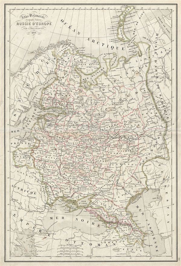
Russie d'Europe.
1850 (dated) 18 x 12.5 in (45.72 x 31.75 cm)
1850 (dated) 18 x 12.5 in (45.72 x 31.75 cm)
Description
This is a beautiful example of Alexandre Delamarche's 1850 map of Russia. It covers the european part of Russia from Sweden to the Ural Mountains and from the Arctic Ocean to the Caspian Sea. When this map was printed, Russia was ruled by Tsar Nicholas I who adopted the doctrine of 'Orthodoxy, Autocracy, and Nationality' and was known to be one of the most reactionary monarchs in Russia. In 1825, Russian army officers, called the Decembrists, protested against Nicholas I's ascension to the throne. The Decembrists, so named because their revolt started in December, favored Nicholas I'st brother, Constantine, who seemed amenable to a British style constitutional monarchy. When Constantine abdicated the throne in 1825, the Decembrists refused to accept the more autocratic rule of Nicholas I. Had Constantine not abdicated and the Decembrists been successful, the bloody Bolshevik Revolution may never have occurred. Throughout, the map identifies various cities, towns, rivers, mountain passes and an assortment of additional topographical details. Political and regional borders are highlighted in outline color. This map was issued by Delamarche as plate no. 30 in his Atlas Delamarche Geographie Modern.
Cartographer
Charles-François Delamarche (August 1740 - October 31, 1817) founded the important and prolific Paris-based Maison Delamarche map publishing firm in the late 18th century. A lawyer by trade, Delamarche entered the map business with the 1787 acquisition from Jean-Baptiste Fortin of Robert de Vaugondy's map plates and copyrights. Delamarche appears to have been of dubious moral character. In 1795, the widow of Didier Robert de Vaugondy, Marie Louise Rosalie Dangy, petitioned a public committee for 1500 livres, which should have been awarded to her deceased husband. However, Delamarche, proclaiming himself Vaugondy's heir, filed a simultaneous petition and walked away with the funds, most of which he was instructed to distribute to Robert de Vaugondy's widow and children. Just a few months later, however, Delamarche proclaimed Marie Dangy deceased, and it is highly unlikely that any funds found their way to Robert de Vaugondy's impoverished daughters. Nonetheless, where Robert de Vaugondy could barely make ends meet as a geographer, Delamarche prospered as a map publisher, acquiring most of the work of earlier generation cartographers Lattre, Bonne, Desnos, and Janvier, thus expanding significantly upon the Robert de Vaugondy stock. Charles Delamarche eventually passed control of the firm to his son Felix Delamarche (c. 1750 - c. 1850) and geographer Charles Dien (1809 - 1870). It was later passed on to Alexandre Delamarche, who revised and reissued several Delamarche publications in the mid-19th century. The firm continued to publish maps and globes until the middle part of the 19th century. More by this mapmaker...
Source
Delamarche, A., Atlas Delamarche Geographie Ancienne et Moderne, (Paris) 1850.
Condition
Very good. Some wear on original centerfold. Blank on verso.