1666 Pierre Du Val Chart of the European Atlantic: Rare First State
EuropeChart-duval-1666$1,200.00

Title
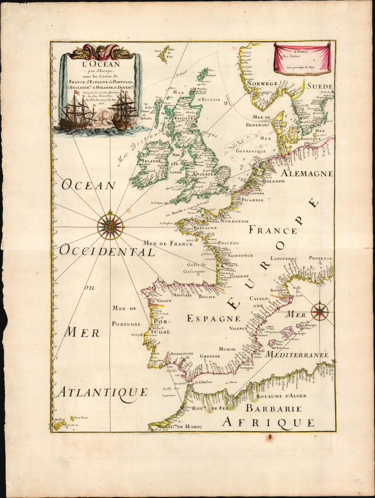
L'Océan pres d'Europe avec les costes de France, d'Espagne, de Portugal, d'Angleterre, de Hollande, de Danemark et suivant les cartes marines les plus nouvelles / Par P. Du Val Geogr. du Roy 1666.
1666 (dated) 18.25 x 13.25 in (46.355 x 33.655 cm) 1 : 7400000
1666 (dated) 18.25 x 13.25 in (46.355 x 33.655 cm) 1 : 7400000
Description
This rare 1666 map by Pierre Du Val captures the state-of-the-art charting of the European Atlantic coast at the time of the Second Anglo-Dutch War (1665 - 1667). Two battles, marked and dated, suggest the chart was drafted before August 1666.
A Closer Look
The chart presents the Atlantic and Mediterranean coasts from Morocco in the south to the Faeroe Islands in the north, and from the island of Madeira to the Mediterranean coasts of Provence and the Baltic coast of Sweden. The British Isles are prominent. The attractively engraved cartouche features a sea battle between two ships, highlighting the martial focus of this chart. The North Sea, here termed Mer Germanique, features depths of shallow regions, notably the Dogger Banks. Two sea battles are marked and dated: between Sussex and the Netherlands, a battle dated 1665 corresponds to the English victory of the battle of Lowestoft. At the Pas de Calais, the 1666 Four Days' Battle is marked. A dotted line starting at the Jutland Bank and separating the British Isles from Norway and the Faeroe Islands marked de Kimmen refers to what would, centuries later, be understood to be the European continental shelf. Despite its compasses and rhumb lines, this is not a working chart; it is rather intended to convey contemporaneous nautical knowledge during the progress of a war fought between two great maritime powers. Though not one of the initial participants, France joined the war in support of the Dutch in 1666; thus, this chart was issued in response to current events.Contemporary Dutch Hydrography
The French entry into the war in 1666 on the side of the Dutch invited interest in the Dutch charts of the period. The presence of de Kimmen here signals Du Val's apparent familiarity with Pieter Goos' work since this feature appears on the Dutch chartmaker's 1655/1666 Paskaarte Vertonende alle de Zèkusten van EUROPA, as well as his Pascaart van de Noort Zee Verthoonende in zich Alle de Custen en Havens daer rontom Gelegen. We have not seen an earlier reference to this feature on a printed chart; it is, for example, absent from the charts of Blaeu. It was retained in the next century on the maps of Guillaume De l'Isle, who named it bilingually as De Kimmen ou le Borneur. The terms, roughly translating to 'horizon' or 'boundary', refer to a point at which the depth of the ocean floor dropped sharply beyond 100 fathoms. Today it is known as the Continental Shelf.Publication History and Census
This map was produced by Pierre Du Val in 1666 for inclusion in his growing atlas,Cartes de Géographie; an example has been noted in a composite atlas by Rumsey. This 1666 first state is rare, having only appeared on the market a few times. It is not noted in OCLC. A second state, dated 1677, appears in later editions of the atlas: we see five examples of that state in institutional collections.Cartographer
Pierre Du Val (May 19, 1619 - September 29, 1683) was a French cartographer and publisher active in Paris during the middle part of the 17th century. He was born Abbeville, Picardie, France, where his father, also Pierre, was a merchant, consul, and alderman. His mother was Marie Sanson, sister of Nicolas Sanson d'Abbeville (1600-1667), the leading French cartographer of his day. Du Val and probably apprenticed in Sanson's workshops. Afterwards, in Paris, he studied geography under Jean-Baptiste Gault, who later became the Bishop of Marseilles. He counseled M. Henri of Savoye, abbot of St. Sorlin, and M. Gilles Bouraut, bishop of Aire and later Evreux, in matters of science and geography. Du Val became Geographe ordinaire to Louis XIV in 1650. His first atlas, the 1654 Cartes Geographiques Methodiquement Divisees, contained few of his own maps and was mostly compiled from reissues of maps by other cartographers. His early work focused on atlases and geographical treatises, but later, he turned his attentions to large separate issue, often multi-sheet maps. After his death in 1683, his widow, Marie Desmaretz, continued his business at least until 1684, after which it passed to his daughters (either Marie-Angelique or Michelle), who published until at least 1688. He is the elder brother of Placide de Sainte Hélène (1648 - 1734), Placidium Augustinum, an Augustine monk and geographer. More by this mapmaker...
Source
Du Val, Pierre, Cartes de Géographie, (Paris: Mariette) 1667.
Condition
Very good. One rust hole not impacting printed image, else an excellent example with generous margins and original outline color.
References
OCLC 1332149843 (1677 second state). Rumsey 15185.050.