1940 Paris Soir Map of World War II in Europe
EuropeEnGuerre-parissoir-1940$500.00

Title
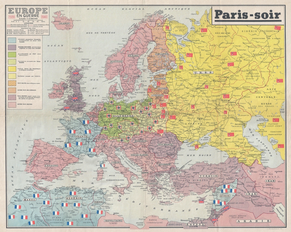
Europe en Guerre 1939 - 1940.
1940 (dated) 23.5 x 29.5 in (59.69 x 74.93 cm) 1 : 8000000
1940 (dated) 23.5 x 29.5 in (59.69 x 74.93 cm) 1 : 8000000
Description
This is a 1940 Paris-Soir map of Europe at the beginning of World War II, specifically during the 'Phoney War' or the 'Drôle de Guerre'. The novel map features astedowns of the French, British, Soviet, and Nazi flags. These could be moved about the map to differentiate belligerent powers, neutral powers, and illustrate alliances, thus allowing one to follow the war's progress.
A Closer Look
Coverage embraces continental Europe from the Atlantic to the Aral Sea and from the Arctic to North Africa. A key situated along the left border explains how colors identify alliances and invasions. Nazi Germany is shaded dark green, with all the territory it has annexed/invaded shaded a lighter green, including Austria, Czechoslovakia, and western Poland. The Soviet Union and eastern Poland are in two shades of yellow, illustrating how Nazi Germany and the Soviet Union divided Poland. The Baltic states and Finland are colored to suggest the influence of the Soviet Union. Countries affiliated with Britain are striped purple and pink. Pink nations are neutral, including (at that time) Italy, since it did not declare war on France and Britain until June 1940.The Phoney War or the Drôle de Guerre
The Phoney War was a period of about eight months (September 3, 1939 - May 10, 1940) between when Great Britain and France declared war on Germany, and when Germany invaded Belgium, the Netherlands, and Luxembourg. During these eight months, almost no fighting occurred in Western Europe, with only small skirmishes between French and German troops. Other 'Phoney War' events include the Soviet invasion of Finland and the German invasion of Denmark and Norway, neither of which was strongly opposed by France or Britain. Both nations were thus nearly caught by surprise when Germany invaded Belgium, the Netherlands, and Luxembourg.Publication History and Census
This map was created and published by Paris-Soir in 1940, most likely in the early spring. We note 7 examples cataloged in OCLC: Bibliothèque nationale de France; the Université catholique de Ouest in Angers, France; the Bibliothèque, archives, musée des mondes contemporains in Nanterre, France; the Bibliothèque Nationale Universitaire de Strasbourg, the National Library of Poland, the University of Oxford, and the Bayerische Staatsbibliothek. It appears on the market from time to time, however this is the only example we have encountered bearing the flag pastedowns.Source
Paris-Soir.
Paris-Soir (October 4, 1923 - August 17, 1944) was a French daily newspaper based in Paris that notoriously continued publication during the German Occupation during World War II. Founded by Eugène Merle, a militant anarchist, the newspaper quickly fell into financial difficulties, which led to Merle losing all association with the paper, and the paper's realignment with the right by 1928. Jean Prouvost became director in 1930 and under his leadership became one of France's leading newspapers, having a circulation of 1.8 million in 1939. But in 1940, when it became clear that Paris was going to be occupied, the staff of Paris-Soir left the city (like thousands of other Parisians) and Prouvost and some of his colleagues eventually settled in Lyon. In Paris, the occupying Germans requisitioned Paris-Soir and printed their own version, using the name and its massive circulation to support the Occupation. Of course, the circulation dropped dramatically. Horrified by their situation and the coopting of their paper by the Nazis, Prouvost and other members of the Paris-Soir staff began publishing a version of their own in Unoccupied France in Lyon. This, however, set them against both the Resistance and the regime of Philippe Pétain based at Vichy. When France was liberated, Paris-Soir was banned from publication due to the connotation of collaboration with the name and Prouvost had to go into hiding to avoid arrest.
Condition
Very good. Even overall toning. Wear along original fold lines. Verso repairs to fold separations.
References
OCLC 494709261, 492330426, 899784045, 1353783444, 165853305.