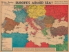
1940 Chicago Sunday Tribune and Rand McNally Map of Europe
EuropesArmedSea-sundaytribune-1940$200.00


Title
Europe's Armed Sea!
1940 (dated) 16.75 x 22 in (42.545 x 55.88 cm) 1 : 7565000
1940 (dated) 16.75 x 22 in (42.545 x 55.88 cm) 1 : 7565000
Description
This is a 1940 Rand McNally and Chicago Sunday Tribune map of Europe during World War II (1939 - 1945). This map, published on May 19, 1940, appeared nine days after Germany invaded Belgium, the Netherlands, and France. It highlights fortifications and air and naval bases throughout Europe and across the Mediterranean Sea in Europe and the Middle East.
History as it Happened
At the time of publication, readers in Chicago were likely following events in Europe with trepidation, as the western Allies had been dealt defeat after defeat at the hands of the German army. The world believed France militarily unassailable behind stalwart and well-planned defenses. However, only weeks after this piece appeared on street corners in Chicago, all three countries fell to the German onslaught.A Closer Look
Icons mark naval (anchor) and air (plane) bases across Europe. Artillery pieces highlight fortifications, including the Maginot and Siegfried lines. These two celebrated fortifications are also highlighted in France and Germany by notations indicated in the legend in the lower left. Fortifications, air, and naval bases are marked in the Middle East and North Africa as well.Publication History and Census
This map was created by Rand McNally and Company and published by the Chicago Sunday Tribune on May 19, 1940. We note a single cataloged example which is part of the collection at the Newberry Library.Cartographer
Rand, McNally and Co. (fl. 1856 - present) is an American publisher of maps, atlases and globes. The company was founded in 1856 when William H. Rand, a native of Quincy, Massachusetts, opened a print shop in Chicago. Rand hired the recent Irish immigrant Andrew McNally to assist in the shop giving him a wage of 9 USD per week. The duo landed several important contracts, including the Tribune's (later renamed the Chicago Tribune) printing operation. In 1872, Rand McNally produced its first map, a railroad guide, using a new cost effective printing technique known as wax process engraving. As Chicago developed as a railway hub, the Rand firm, now incorporated as Rand McNally, began producing a wide array of railroad maps and guides. Over time, the firm expanded into atlases, globes, educational material, and general literature. By embracing the wax engraving process, Rand McNally was able to dominate the map and atlas market, pushing more traditional American lithographic publishers like Colton, Johnson, and Mitchell out of business. Eventually Rand McNally opened an annex office in New York City headed by Caleb S. Hammond, whose name is today synonymous with maps and atlases, and who later started his own map company, C. S. Hammond & Co. Both firms remain in business. More by this mapmaker...
Source
Chicago Sunday Tribune, May 19, 1940.
Condition
Very good. Newsprint. Light wear along original centerfold. Closed minor margin tears professionally repaired on verso. Loss to lower right margin corner not effecting printed area. Old tape repairs evident on verso.
References
OCLC 1032553536.