
This item below is out of stock, but another example (left) is available. To view the available item, click "Details."
Details
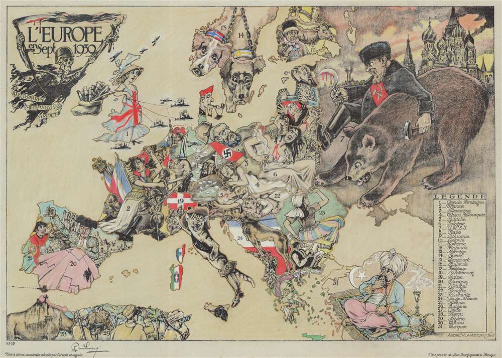
1939 Vlaanderen Serio-Comic Map of Europe at the Outbreak of World War II
1939 (undated) $5,000.00
1939 Vlaanderen Serio-Comic Map of Europe at the Outbreak of World War II
EuropeSept1939-vlaanderen-1939$6,000.00

Title
L'Europe en Sept. 1939.
1939 (undated) 24 x 33.25 in (60.96 x 84.455 cm)
1939 (undated) 24 x 33.25 in (60.96 x 84.455 cm)
Description
This is a striking 1939 André Vlaanderen serio-comic map of 'Europe in September 1939' just after the outbreak of World War II - hand colored and signed by the author in a limited release of 150 (this is no. 10). Vlaanderen adopts the serio-comic map genre to convey the violence, chaos, and fear then enveloping Europe. He pays tribute to Fred Rose, the popularizer of the serio-comic map, by drawing Norway and Sweden (Nos. 13 and 14) as dogs, following Rose's 1899 Angling in Troubled Waters. Instead of providing our own explication of this map, we offer Vlaanderen's words in translation from a French version of the accompanying typewritten Dutch text.
Berendsohn's Komische Karte des Kriegsschauplatzes, published during the Crimean War, and Paul Hadol's Nouvelle Carte d'Europe dressée pour 1870 push the genre a step further by symbolically and anthropomorphically using cartoon figures to define the geographical space of the countries themselves. Popular political satire magazines embraced the concept, combining cartoons and cartography to produce sensational graphics.
In 1877, the English cartoonist Fred W. Rose (1849 - 1915) published his first 'Serio-Comic' map, A Serio-Comic War Map. Rose's work earned instant widespread popularity - something earlier examples of the genre failed to garner. Afterwards, he followed with England on Guard (1878), A Comic Map of the British Isles (1880), Angling in Troubled Waters (1899), and John Bull and his Friends (1900). This last and most celebrated serio-comic map famously depicts Russia as a grasping octopus - a motif that would continue well into the 20th century. Rose's creations influenced artists worldwide, with this style of cartography reaching as far as Russia, Persia, and Japan. By the early 20th century, propagandists embraced the genre, especially during World War I, when serio-comic maps appeared in English, German, Portuguese, Dutch, and French. After World War I (1914 - 1918), the genre's popularity waned, making André Vlaanderen's 1939 map a stylistic outlier.
Vlaanderen's Explanation of the Map
Among the four known examples (all of which are in private hands) two, including this one, are accompanied by explanatory text. The text accompanying the present example is written in Dutch, but we are translating from another in French, as follows:In the middle the German ogre (3) is represented by Blue Beard, helmeted and wearing a strap bearing the swastika. The tyrant, having already assassinated two women Austria (5) and Czechoslovakia (4), stabs Poland (6) with his left hand. A fluttering sleeve of her blouse simulates the 'corridor'; close by, The Free City of Danzig, is marked in red. With his right hand Blue Beard brandishes a sharpened blade to the west, where Marianne (2) the French virgin, styled with a Phrygian cap, commands her troops. To the right of the enemy, the head of a murdered Jew is wedged, and we glimpse an English airplane that drops propaganda leaflets over the country. Great Britain (1) is symbolized by Dame Albion, directing her fleet, with her bag overflowing with reinforcements. The Hebrides and Shetland Islands are indicated by airplanes. To the northeast, the Finnish reindeer herder (12) watches with discontent brutal Russia (7), who, leaning on his bear, tramples embarrassed and bloody Poland; in the background the towers of Red Square in Moscow are seen. The three little Baltic states: Lithuania (9), Latvia (10), and Estonia (11), observe in terror the colossus, armed with a hammer and a bloody sickle and ask themselves what fate is reserved for them.
Hungary (22) feels suffocated under the weight of the corpses of its two neighbors. Romania (23) watches the Russian bear with dread, and Bulgaria (26) also finds himself in an unenviable situation. Puss in Boots represents Italy (8), wearing a sash with the fascio romano on a black background and wearing a plumed hat; he doesn't inspire any confidence. Corsica and Sardinia are covered by the flag of the power on which they depend. In Sicily, a cannon aimed at Tunisia. Albania (25) forms for the Puss in Boots 'a nest of bothersome mice'. Yugoslavia (24), guard dog, is ready to defend its flag and the piece of meat it holds between its feet.
Spain (20), represented by a bull fighter, who doesn't have the time to concern himself with European affairs, since he must devote all his attention to repairing his holed red cape; behind him we see his still devastated country in ruins. At its southern tip, at Gibraltar, emerges the British cannon, that protects the approaches to the Mediterranean. Portugal (21), nestled in the folds of his national flag, makes eyes at Dame Albion and at Marianne.
Follow the other neutrals: a Dutch soldier (16) in front of his flag, aims at a plane, that passes over his territory. Belgium (17) also posed as a sentinel, is ready to defend his three color flag and his neutrality.
No. 18 designates Luxembourg and No. 19 represents the Swiss cross. In the north, Norway and Sweden are symbolized by guard dogs, held on leash and with their collars in national colors. The Danish (15) still smokes his pipe without losing sight of everything happening below him.
In the south, Greece (27) is represented by Athena (Minerva) posted in front of Ionic columns, armed with a lance and wearing a helmet ornamented with feathers.
No. 31 shows us Turkey, sitting on his Smyrna rug and savoring his hookah, while he raises his eyes toward what is going on higher up. Behind him the crescent and sickle shine on a red background.
Finally we notice again the coast of North Africa with Morocco (28) - of which Spanish Morocco is delineated -, Algeria (29), and Tunisia (30). The illustrated title of this historic document shows Death, helmeted and armed with his bloody scythe, carrying a war torch. A floating ribbon bears as a motto a citation from Horace 'Ille terrarium mihi angulus ridet' (this corner of ground smiles at me), a devise with a double symbolic meaning, that goes as well with this part of Europe, chosen by Mars as his field of activity, as Poland which, desired by both Germany and Russia, was the origin of the worldwide catastrophe.
André Vlaanderen
Painter-illustrator
23 Quai du Miroir
Bruges
Historical Context - Events Leading to World War II
Following the 1933 rise of the Nazi Party and Adolf Hitler (1889 - 1945), German ethno-nationalism, rearmament, and bellicosity threatened Europe's fragile harmony. In March 1938, Germany annexed Austria, a event known as the Anschluss. Nazi Germany then began presenting itself as the 'advocate' of ethnic Germans living in the Sudetenland, Czechoslovakia. In October 1938, the Munich Agreement transferred the Sudetenland to Germany - negotiated as part of British Prime Minister Neville Chamberlain's policy of appeasement. At the time, Hitler claimed the Sudetenland would be his last land grab in Europe. Then, in Mach 1939, Germany invaded Czechoslovakia. In late March, Hitler forced Lithuania to cede Klaipeda and postured for the Free City of Danzig. His demands for Danzig forced the British and French to act, which took the form of a pledge to guarantee Poland's independence. After fascist Italy conquered Albania in April 1939, similar guarantees were declared for Romania and Greece. In late August, Germany signed a non-aggression pact with the Soviet Union, and shortly thereafter, on September 1, 1939, invaded Poland, igniting World War II. The United Kingdom and France declared war on Germany on September 3, and the Soviet Union invaded Poland on September 17.Serio-Comic and Satirical Maps
While whimsical and satirical prints date to the 16th century, the first political cartoon maps in the serio-comic genre appeared after the failed Springtime of the Peoples Revolutions of 1848. The earliest known was issued in 1848 by F. Werner of Vienna, Politische Karte von Oesterrich. It is one of the few maps to address the Revolutions, highlighting reactionary and conservative forces within the Austrian Empire. A German map created by Ferdinand Schrieder, Rundgemaelde von Europa im August MDCCCCXLIX and Kaart van Europa 1859 by Emrik and Binger take the next step by caricaturizing European countries directly on the map - like giant chess pieces.Berendsohn's Komische Karte des Kriegsschauplatzes, published during the Crimean War, and Paul Hadol's Nouvelle Carte d'Europe dressée pour 1870 push the genre a step further by symbolically and anthropomorphically using cartoon figures to define the geographical space of the countries themselves. Popular political satire magazines embraced the concept, combining cartoons and cartography to produce sensational graphics.
In 1877, the English cartoonist Fred W. Rose (1849 - 1915) published his first 'Serio-Comic' map, A Serio-Comic War Map. Rose's work earned instant widespread popularity - something earlier examples of the genre failed to garner. Afterwards, he followed with England on Guard (1878), A Comic Map of the British Isles (1880), Angling in Troubled Waters (1899), and John Bull and his Friends (1900). This last and most celebrated serio-comic map famously depicts Russia as a grasping octopus - a motif that would continue well into the 20th century. Rose's creations influenced artists worldwide, with this style of cartography reaching as far as Russia, Persia, and Japan. By the early 20th century, propagandists embraced the genre, especially during World War I, when serio-comic maps appeared in English, German, Portuguese, Dutch, and French. After World War I (1914 - 1918), the genre's popularity waned, making André Vlaanderen's 1939 map a stylistic outlier.
Publication History and Census
This map was drawn, hand colored, and signed by André Vlaanderen in 1939. Although 150 were printed (per the map), only three, nos. 9, 10 (this example), and 13, are known to have survived.Cartographer
Cornelis André Vlaanderen (September 1, 1881 - August 5, 1955) was a Dutch artist and graphic artist. He was born in Amsterdam to an unknown father and his mother died on July 10, 1833, leaving him orphaned. He went to the 'Hospice Wallon' (Waals Gereformeerd Weeshuis) in Amsterdam, where he lived until he turned 18 in 1899. He attended primary and secondary school in Amsterdam. He worked in the architectural firm of Eduard Cuypers from 1899 until 1905, and taught classes at the Quellinus School of Applied Arts in Amsterdam from 1904 until 1910. He left Cuypers firm in 1905 to open his own business and began designing advertising for the Gazelle Rijwielfabriek (a bicycle manufacturer) not long afterwards. It is estimated that he created at least 500 advertisements for Gazelle between 1914 and 1929. He even designed Gazelle's logo and headset plate. Vlaanderen was drafted into the Dutch Army on March 12, 1901, and was assigned to the 7th Infantry Regiment. He was still in the army when the Netherlands mobilized their forces to fight World War I. Vlaanderen moved to Belgium in August 1929. He first settled in Ghent and in August 1930 moved to the suburbs of Bruges (Brugge). He lived in Bruges from 1939 until his death at Spiegelrei 23. He married his first wife (whom he knew from the orphanage), Augusta Varangot (1892 - 1976), on November 1, 1906, with whom he had two children. The couple divorced on June 30, 1916, and Vlaanderen married his second wife, Petronella Andringa (1882 - 1948) on July 20, 1886, with whom he had three children. More by this mapmaker...
Condition
Very good. Hand pastel color. Print No. 10 of a limited edition of 150.
References
Roderick M. Barron, 'Bringing the map to life: European satirical maps 1845-1945', Belgeo [Online], 3-4 | 2008, Online on 06 August 2014, Accessed 29 December 2021.