1867 Malte-Brun Map of the North Pole and Proposed Polar Exploration
ExpeditionsArctique-maltebrun-1867$750.00

Title
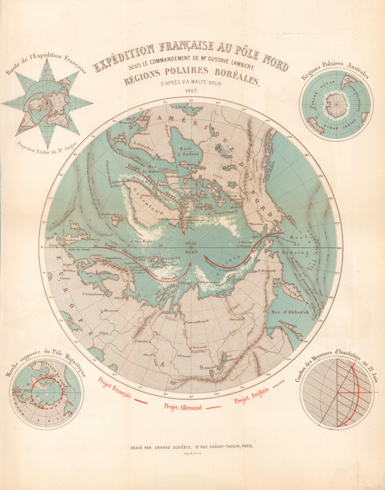
Expédition Française au Pôle Nord sou le Commandement de Mr. Gustave Lambert. Régions Polaires Boréales.
1867 (dated) 13 x 11.75 in (33.02 x 29.845 cm)
1867 (dated) 13 x 11.75 in (33.02 x 29.845 cm)
Description
This is an 1867 Victor-Auguste Malte-Brun and Georges Erhard Schièble map of the North Pole highlighting three proposed polar expeditions. The map captures the peak of the global competition to reach the North Pole. Reaching the Pole was considered a matter of national pride, with both government-funded and private expeditions making the attempt. This map captures rival proposals by French, English, and German explorers.
A Closer Look
With the North Pole at the center, coverage embraces the northern parts of the Earth as far south as the Black Sea and the Great Lakes. Red lines trace proposed English, French, and German expeditions to the North Pole. Four smaller maps (one in each corner) illustrate the proposed route of the French expedition, the South Polar regions, the variation in the Magnetic North Pole, and the average insolation curve for June 21, 1867, respectively.Three Proposed Expeditions
Three red lines trace proposed expeditions to reach the North Pole. These were proposed by Sherard Osborn (British Royal Navy officer and Arctic explorer), Augustus Petermann (German cartographer and publisher), and Gustave Lambert (French hydrographer and Arctic explorer). Each was either an experienced Arctic (Osborn and Lambert) traveler or considered a geographical expert (Petermann).- Petermann: Petermann's (1822 - 1878) efforts to push Germany into the race to explore the North Pole gave rise to the 1868 First German North Polar Expedition, which explored the northeastern coast of Spitsbergen (as suggested by Petermann) and prepared the way for the 1869 Second German North Polar Expedition
- Osborn: Osborn's (1822 - 1875) proposal led to the 1875-76 British Arctic Expedition. Osborn himself was set to be a member of the expedition committee but tragically died in London only a few days after the expedition set sail. The expedition, nonetheless, pressed on. They successfully pushed farther north than any previous voyage, reaching a record latitude of 83°20'26'' N, but were ultimately thwarted by extreme cold, scurvy, and difficult ice conditions. Despite not reaching the Pole, the expedition gathered valuable scientific and geographic data, mapping parts of northern Greenland and Ellesmere Island and disproving the long-held theory of an open polar sea.
- Lambert: Lambert's (1824 - 1871) proposal failed to produce an expedition. Lambert himself was organizing the expedition, which had an estimated cost 600,000 French Francs. He began raising money as early as 1867 and by July 1870 raised 400,000 Francs and acquired a ship for the voyage, the Boréal. Political events nonetheless intervened. When the Franco-Prussian War (1870 - 1871) broke out, the 46-year-old Lambert determined that his talents would best serve his country in the army. Although assigned to a company of francs-tireurs (marksmen) in Bordeaux, it instead went to Parios. He was mortally wounded in the Second Battle of Bouzenval on January 19, 1871, and died days later, on January 27.
Publication History and Census
This map was engraved by Georges Erhard Schièble after a map created by Victor Adolphe Malte-Brun and printed by the Imprimerie Monrocq for publication in Adrien Desprez's book Les voyageurs au pole nord depuis les premières expeditions scandinaves jusqu'a celle de M. Gustave Lambert. We note 3 examples of the separate map cataloged in OCLC, which are part of the collections at the Newberry Library, the University of Chicago, and the Université Toulouse 1 Capitole. An example is also part of the David Rumsey Map Collection. The book appears in about a dozen collections worldwide.CartographerS
Conrad Malte-Brun (August 12, 1755 - December 14, 1826) was an important late 18th and early 19th century Danish / French cartographer and revolutionary. Conrad was born in Thisted, Denmark. His parents encouraged him to a career in the Church, but he instead enrolled in the University of Copenhagen. In the liberal hall of academia Conrad became an ardent supporter of of the French Revolution and the ideals of a free press. Despite the harsh censorship laws of crown prince Frederick VI, Malte-Brun published numerous pamphlets criticizing the Danish government. He was finally charged with defying censorship laws in 1799 and forced to flee to Sweden and ultimately France. Along with colleague Edme Mentelle, Malte-Brun published his first cartographic work, the Géographie mathématique, physique et politique de toutes les parties du monde (6 vols., published between 1803 and 1807). Conrad went on to found Les Annales des Voyages (in 1807) and Les Annales des Voyages, de la Géographie et de l'Histoire (in 1819). He also founded the Paris Société de Géographie . In time, Conrad Malte-Brun became known as one of the finest French cartographers of his time. His son Victor Adolphe Malte-Brun (1816 - July 13, 1889) followed in his footsteps, republishing many of Conrad's original 18th century maps as well as producing numerous maps of his own. The Malte-Brun firm operated well into the 1880s. More by this mapmaker...
Georges Erhard Schièble (1823 – November 23, 1880) was a German printer active in Paris during the middle to late 19th century. Erhard was born in Forchheim, Baden-Württemberg, and relocated to Paris in his 16th year, where he apprenticed under his cousin, an engraver and mapmaker. In 1852, after 6 years with the Royal Printing Office, he started his own business. Around this time, he also became a naturalized French citizen. From his offices on Rue Bonaparte, he produced several important maps, and a detailed topography of Gaul for Napoleon III's History of Julius Caesar. In 1865 he took on larger offices expanding his operations to include a lithographic press. He was among the first to introduce printed color maps and pioneered photo-reduction, including the process known as Erhard reproduction. After Erhard's death in 1880, the firm was taken over by his sons and run under the imprint of 'Erhard Frères' until 1911. Learn More...
Jean Noël Monrocq (December 25, 1819 - February 18, 1913) was a French printer and bookseller active in Paris in the mid to late 19th century. Monrocq was born on Chrismtas day, hence his name, in Trelly, La Manche, the son of a farmer. In 1839 he moved to Paris for a more urban lifestyle. Although he had little formal education, he found work with the Parisian book and print seller Delarue. Meating some success, he opened his own print shop in 1848. He initially applied for a booksellers patent in 1853, but the application was initially rejected. It was formally approved in 1877. In 1859, he received a lithographers patent for artistic and industrial prints for education purposes. He took over the presses of Louis Etienne Stanislas Petit in 1859, but did not relieve a formal intaglio imprint until 1865. In March 1874, he established a branch of his lithographic printing press in Ivry, Rue de Vitry, where he moved part of his equipment. He became known for zincographic lithography - the process of etching plates into zinc, which he claimed falsely to have invented. He did nonetheless, contributed significantly to the industrialization of the printing with zinc plates. Being cheap, simple to make, easy to modify, zinc plates became the standard for news printing. Zincography under Monrocq was also ideally suited to map production. The Monrocq produced a significant corpus of maps. The firm spearheaded the movement to centralize map production in France. The firm continued well after his death, issuing maps for both Hachette Taride. For a long time, his son, Léon Monrocq (1857 - 1902) worked with him specifically printing maps, unfortunately he died young. The firm for a time was operated by the founder's son-in-law, who took the name Gaillac-Monrocq. Jean Noël Monrocq's grandson Lucien Monrocq, eventually took over the publishing arm of the firm. Learn More...
Source
Desprez, A., Les voyageurs au pole nord depuis les premières expéditions scandinaves jusqu'a celle de M. Gustave Lambert (Paris: Charles Norbet) 1868.
Condition
Good. Light wear along original fold lines. Light toning. Verso repairs to fold separations.
References
Rumsey 16357.000. OCLC 244636850, 966290078.