1884 Andriveau-Goujon Map of Southeast Asia and East Indies
ExpeditionTonkin-andriveaugoujon-1884$400.00

Title
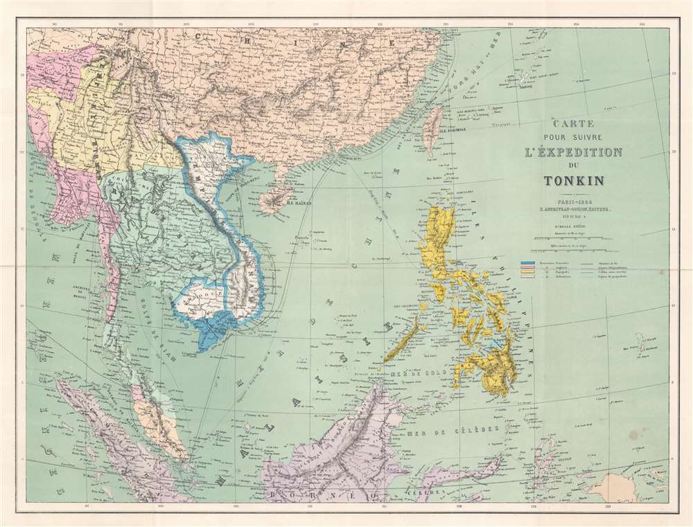
Carte pour suivre l'Éxpedition du Tonkin.
1884 (dated) 18.75 x 24.75 in (47.625 x 62.865 cm) 1 : 8000000
1884 (dated) 18.75 x 24.75 in (47.625 x 62.865 cm) 1 : 8000000
Description
This is an 1884 Eugène Andriveau-Goujon map of Southeast Asia and the East Indies published during the French Tonkin Campaign (Expédition du Tonkin). The map capitalizes on French public interest in the fighting in Tonkin (Tong-King). Andriveau-Goujon uses color to highlight colonial possessions of France, England, the Netherlands, and Spain, clarifying the politics in play. He also includes numerous cities and towns, along with shipping routes and undersea cables.
The Tonkin Campaign
The Tonkin Campaign was fought between the French Expeditionary Force, the Vietnamese, and the Black Flag Army, a guerrilla group operating in Tonkin. The French force, intending to exact revenge on the Chinese and the Black Flag Army, had as a final objective the occupation of Tonkin and the establishment of a protectorate. The fighting in Tonkin raged from June 1883 until July 1884 before the Chinese entered the war in earnest and the wider Sino-French War (1884 - 1885) began. The Sino-French War lasted from August 1884 until April 1885, after which the French began a year-long pacification campaign in Tonkin. In April 1886, fighting mostly ended and the expeditionary corps was reduced to a division. Nonetheless, Tonkin was not effectively pacified until about 1896.Publication History and Census
This map was created and published by Eugène Andriveau-Goujon in 1884. We note a single example cataloged in OCLC, at the Bibliothèque Nationale de France. We also note an additional example at American Geographical Society Library at the University of Wisconsin Milwaukee.Cartographer
Eugène Andriveau-Goujon (1832 - 1897) was a map publisher and cartographer active in 19th century Paris. The firm was created in 1825 when Eugène Andriveau married the daughter of map publisher Jean Goujon - thus creating Andriveau-Goujon. Maps by Andriveau-Goujon are often confusing to identify as they can be alternately singed J. Goujon, J. Andriveau, J. Andriveau-Goujon, E. Andriveau-Goujon, or simply Andriveau-Goujon. This refers to the multiple generations of the Andriveau-Goujon dynasty and the tendency to republish older material without updating the imprint. The earliest maps to have the Andriveau-Goujon imprint were released by Jean Andriveau-Goujon. He passed the business to his son Gilbert-Gabriel Andriveau-Goujon, who in 1858 passed to his son, Eugène Andriveau-Goujon, under whose management the firm was most prolific. Andriveau-Goujon published numerous fine pocket maps and atlases throughout the 19th century and often worked with other prominent French cartographers of the time such as Brue and Levasseur. The firm's stock was acquired by M. Barrère in 1892. More by this mapmaker...
Condition
Very good. Light wear along original fold lines. Verso repairs to fold separations and at fold intersections. Two small areas of infill at fold intersections.
References
OCLC 494850447.