This item has been sold, but you can get on the Waitlist to be notified if another example becomes available, or purchase a digital scan.
1662 Blaeu Map of Eastern Canada: Newfoundland, Nova Scotia, Labrador
ExtremaAmericae-blaeu-1662$700.00

Title
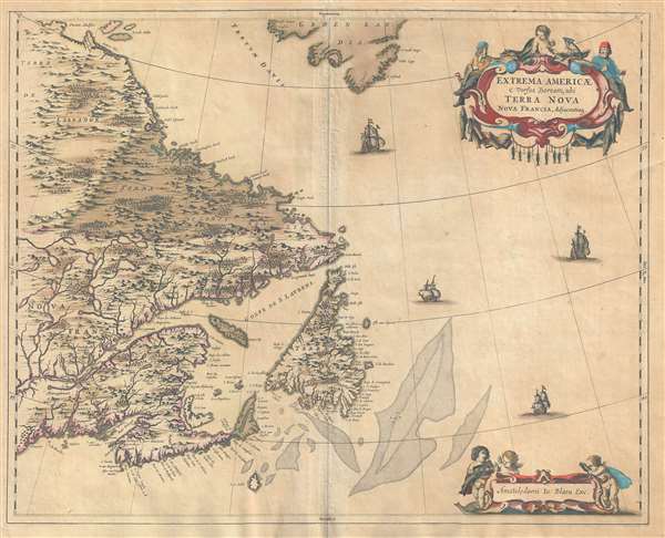
Extrema Americae Versus Boream, ubi Terra Nova Nova Franci.
1662 (undated) 18 x 22.5 in (45.72 x 57.15 cm) 1 : 5000000
1662 (undated) 18 x 22.5 in (45.72 x 57.15 cm) 1 : 5000000
Description
An old color example of Johannes Blaeu's 1662 map of eastern Canada, including Nova Scotia, Newfoundland, Cape Breton Island, and Labrador. Blaeu based this maps on the great 1632 Nouvelle France map of Samuel de Champlain as well as Dutch East India Company (VOC) maps by Hessel Gerritsz, Johannes de Laet (1630), and Jodocus Hondius (1636). With such distinguished sources, this was one of the most comprehensive maps of the eastern part of New France then available – particularly with its detailed mapping of the lakes to the north of the Saint Lawrence estuary. The focus of the map, the rich cod fisheries of the Grand Banks, here shaded at center, is underscored by the addition of fish and fishermen to the baroque title cartouche in the upper right.
Blaeu introduced this map in the 1662 first edition of the Atlas Major. The Atlas Major added some 185 new maps to Blaeu's extant six volume Theatrum Orbis Terrarum. Of these, the present map was the only one pertaining to North America. Previous to Johannes Blaeu's compilation of this map, this region had been woefully unrepresented in the Blaeu corpus with only the Willem Blaeu's 1617 general map of North America addressing it.
Shortly after this map was issued, the 1672 Great Amsterdam Fire destroyed the Blaue workshop and forced the closing of the Blaeu firm. Between 1662 and 1672 only five issues of the Atlas Major were released, making this map exceptionally scarce on the market. Nonetheless, unlike most Blaeu plates, this plate for this map seems to have survived the Great Fire as evidenced by scarce c. 1700 reissues of the map under the Pierre Mortier and later, the Covens and Mortier, imprints.
Cartographer
Joan (Johannes) Blaeu (September 23, 1596 - December 21, 1673) was a Dutch cartographer active in the 17th century. Joan was the son of Willem Janszoon Blaeu, founder of the Blaeu firm. Like his father Willem, Johannes was born in Alkmaar, North Holland. He studied Law, attaining a doctorate, before moving to Amsterdam to join the family mapmaking business. In 1633, Willem arranged for Johannes to take over Hessel Gerritsz's position as the official chartmaker of the Dutch East India Company, although little is known of his work for that organization, which was by contract and oath secretive. What is known is his work supplying the fabulously wealthy VOC with charts was exceedingly profitable. Where other cartographers often fell into financial ruin, the Blaeu firm thrived. It was most likely those profits that allowed the firm to publish the Theatrum Orbis Terrarum, sive, Atlas Novus, their most significant and best-known publication. When Willem Blaeu died in 1638, Johannes, along with his brother Cornelius Blaeu (1616 - 1648) took over the management of the Blaeu firm. In 1662, Joan and Cornelius produced a vastly expanded and updated work, the Atlas Maior, whose handful of editions ranged from 9 to an astonishing 12 volumes. Under the brothers' capable management, the firm continued to prosper until the 1672 Great Amsterdam Fire destroyed their offices and most of their printing plates. Johannes Blaeu, witnessing the destruction of his life's work, died in despondence the following year. He is buried in the Dutch Reformist cemetery of Westerkerk. Johannes Blaeu was survived by his son, also Johannes but commonly called Joan II, who inherited the family's VOC contract, for whom he compiled maps until 1712. More by this mapmaker...
Condition
Good. Even toning. Backed on archival tissue.
References
Boston Public Library, Leventhal Map Center,. Phillips (atlases) 471 (Dutch edition). Burden, P., The Mapping of North America, 371, pp. 142-145.