
1931 Knapp Volvelle Map of the United States and Europe

This item has been sold.
Interesting Facts About United States. Interesting Facts About Europe.
Spin the volvelle and learn about the United States and Europe!
Choose a Collection:
- Digital Map Information
- Suitable for large format printing
- Full resolution TIFF file
- ICC color profile embedded
- Delivered instantly via download link
This Item
Enquire
Spin the volvelle and learn about the United States and Europe!
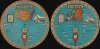
A wonderful educational tool, this is a fully functional 1931 A. Knapp volvelle map of the United States and Europe.A Closer Look
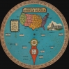
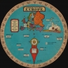
With the United States on one side and Europe on the other, the central disc on both sides spins so the red arrow points to a state or country along the outer ring. On the United States side, information included on the outer ring is the state's name, nickname, and number on the map. By numerically identifying the states, the volvelle provides a geography lesson alongside interesting facts. As the wheel turns to each state, population, square mileage, capitol, main river, and the year it entered the Union appear in windows cut into the central disk. An illustration of the U.S. Capitol Building in Washington, D.C., and statistics concerning the continental United States and the highest and lowest points in North America adorn the central disc as well.On the European side, the country name and map number appear on the outer ring, providing the same geography lesson as on the United States side. The information provided in the windows includes the capitol and its population, the country's total area and population, the type of government, and the time in the country relative to New York City.
Publication History and Census
This volvelle map was created and published by A. Knapp in 1931. We note a single example cataloged in OCLC, located at the University of Wisconsin Madison. This volvelle appears on the market from time to time.Condition
Average. Both disks spin easily. Heavy soiling to United States side. Edge wear.
References
OCLC 973888399.