This item has been sold, but you can get on the Waitlist to be notified if another example becomes available, or purchase a digital scan.
1939 Sundberg Map of France
FairLandFrance-sundberg-1939$150.00

Title
Fair Land of France.
1939 (dated) 15 x 22 in (38.1 x 55.88 cm) 1 : 2700000
1939 (dated) 15 x 22 in (38.1 x 55.88 cm) 1 : 2700000
Description
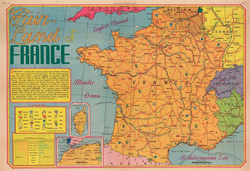
This is a 1939 Edwin Sundberg map of France. Sundberg uses icons to mark regions where specific resources, including champagne, cheese, and wine, are cultivated, mined, or raised. France's major highways, and those of surrounding countries, are illustrated in red, and dashed lines mark international steamer routes. A text box along the left border discusses France's economic success, its population, and its geographic size. Insets, situated in the lower left quadrant, focus on Corsica and France's North African colonies, Morocco, Algeria, and Tunisia. A graph in the lower left corner compares France's imports and exports and differentiates them by country of export or import.
Publication History and Census
This map was drawn by Edwin Sundberg and published in the February 26, 1939 edition of the Sunday News. Even though Sundberg's works were produced for a New York City newspaper, his maps appear to have survived poorly, and are scarce on the market today. This map represents the only known surviving example.Cartographer
Edwin L. Sundberg (1898 - 1978) was an American cartographer known for his pictorial pieces. Sundberg was a staff artist for the Sunday News in New York City and eventually became Chief Cartographer in charge of a small staff of artists. More by this mapmaker...
Condition
Very good. Newsprint. Exhibits wear along original centerfold. Closed margin tears professionally repaired on verso. Text and printed images on verso.