1774 Benard/ Hawkesworth Chart of the Falkland Islands
Falklands-benard-1774$250.00

Title
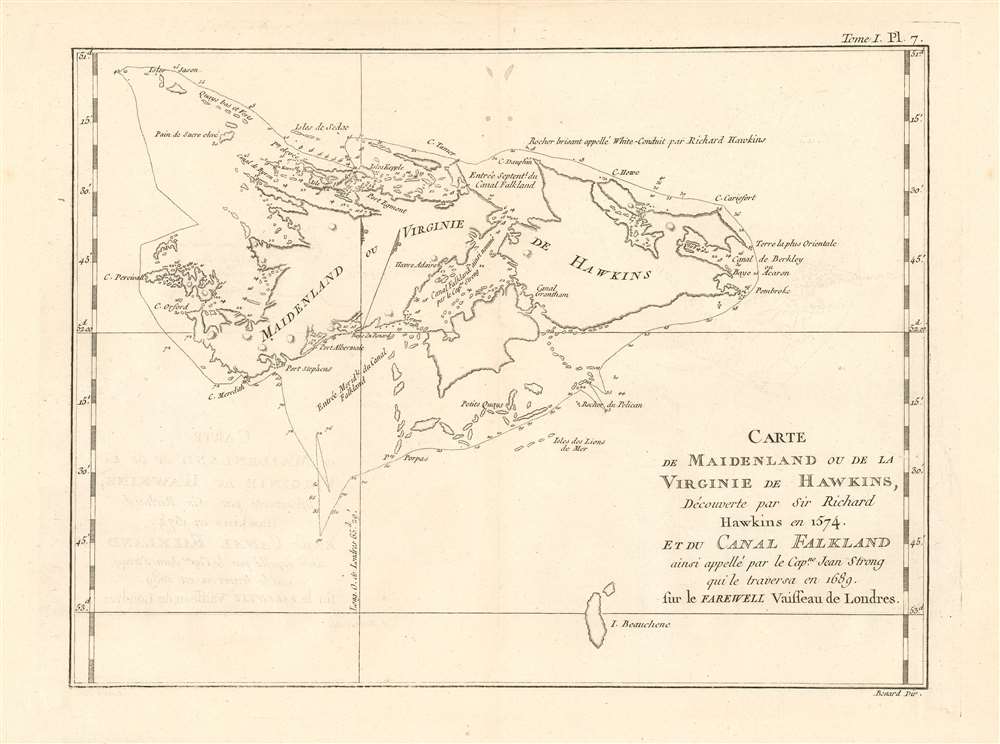
Carte de Maidenland ou de la Virginie de Hawkins, Découvere par Sir Richard Hawkins en 1574 et du Canal Falklanf ainsi appellé par le Cap.ne Jean Stron qui le traversa en 1689 sur le Farewell Vaisseu de Londres.
1774 (undated) 8.5 x 11.75 in (21.59 x 29.845 cm) 1 : 1000000
1774 (undated) 8.5 x 11.75 in (21.59 x 29.845 cm) 1 : 1000000
Description
This 1774 Hawkesworth map of the Falkland Islands, or Malvinas shows the charting of the archipelago's waters just as the British were about to withdraw from active possession of the islands in anticipation of the American Revolutionary War. The place name used here, 'Maidenland ou Virginie de Hawkins' refers to the name bestowed on the islands by English commander Richard Hawkins, combining his own name with that of Queen Elizabeth I, the 'Virgin Queen.' (It was later determined that Hawkins had actually sighted only Steeple Jason island, one of the very small islands appearing in the northwest corner of the map.) The archipelago did appear on earlier maps based on the Portuguese, though the attributions of early sightings are uncertain and at odds with one another.
Hawkesworth
English writer John Hawkesworth's 1773 Account of the Voyages was intended to reveal the travels of three great English circumnavigators of the 18th century: Byron and Mouat's 1763 journey aboard HMS Dolphin and Tamar; the 1767 circumnavigation of Wallis and Carteret aboard HMS Dolphin and the Swallow; and the 1769 voyage of the Endeavor under then - Lieutenant James Cook. This particular chart pertains mainly to the voyages of Byron, despite that Captain's name not appearing on it. Hawkesworth references Hawkins, certainly, as the notional first Englishman to have found the islands. He also refers to Captain John Strong, commander of Welfare, who sailed between the two principal islands in 1690 and called the passage 'Falkland Channel' (now Falkland Sound), after Anthony Cary, 5th Viscount Falkland who had financed the expedition and later became First Lord of the Admiralty. In 1765 Captain John Byron (unaware the French had established Port Saint Louis on East Falkland) explored West Falkland, naming Port Egmont and claiming the islands for Britain. The next year, a permanent settlement was established there. The French abandoned the colony in deference to Spain, who in 1767 formally assumed control of Port St. Louis in East Falkland - renaming it Puerto Soledad (the settlement is omitted from this map.)The Falklands Crisis
In June of 1770, the Spanish commander, Don Juan Ignacio de Madariaga Brought five armed ships and 1400 soldiers from Argentina to force the British to leave Port Egmont. A greater show of British force brought on a standoff: (War was averted by France's refusal to support the Spanish in the conflict.) Following the conflict, Egmont would become a crucial way station for British ships sailing around Cape Horn.The Withdrawal
The incipient American Revolutionary War brought on economic pressure, and would lead the British to withdraw from many overseas settlements in 1774. Hawkesworth's English edition of 1773 predates the withdrawal by a year, and that data is reflected on this French edition of the map.Publication History and Census
This chart was engraved for inclusion in John Hawkesworth's Relation des voyages entrepris par ordre de Sa Majeste britannique actuellement regnante, in its French edition of 1774. The separate engraving appears to be neglected by institutional collections, appearing catalogued only at National Library of Australia according to OCLC. The full text is well represented in institutional collections.CartographerS
Robert Bénard (1734 - c. 1785) was a French engraver. Born in Paris, Bénard is best known for supplying a significant number of plates (at least 1,800) for the Encyclopédie published by Diderot and Alembert. He also is remembered for his work with the Académie des Sciences, most notably the Descriptions des Arts et Métiers More by this mapmaker...
John Hawkesworth (c. 1715 - November 16, 1773) was an English born writer and editor born London. Hawkesworth, who is said to have been self educated, succeeded Samuel Johnson as the parliamentary debate compiler for "Gentleman's Magazine". He was a deeply religious and moral map who brilliant defense of morality earned him an LL. D degree from the Archbishop of Canterbury. Hawkesworth went on to publish a series of scholarly books and essays including a 12 volume edition of Jonathan Swift's work. In 1772 Hawkesworth was commissioned by the Admiralty to compile and edit James Cook's journals. The resultant work An Account of the Voyages undertaken ... for making discoveries in the Southern Hemisphere was one of the first ethnographic account of the South Seas and was widely published in England and abroad. Though highly influential, Hawkesworth's work received heavy criticism from scholars who claim that he liberally altered much of the text in the name of morality. Learn More...
Source
Hawkesworth, John Relation des voyages entrepris par ordre de Sa Majeste britannique actuellement regnante. (Paris : Chez Saillant et Nyon) 1774
Condition
Very good condition. Four filled wormholes not impacting printed image.
References
OCLC 499460221.