This item has been sold, but you can get on the Waitlist to be notified if another example becomes available, or purchase a digital scan.
1938 Harbold Pictorial Map of the World and its Pirates
FamousPirates-harbold-1938$800.00

Title
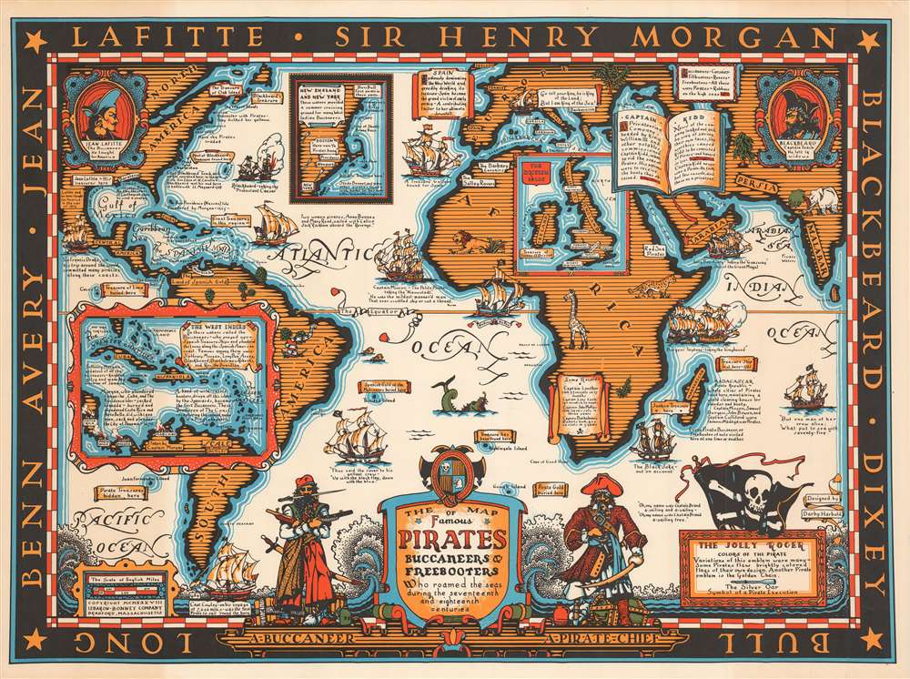
The Map of Famous Pirates Buccaneers and Freebooters who roamed the seas during the seventeenth and eighteenth centuries.
1938 (dated) 22.25 x 30 in (56.515 x 76.2 cm) 1 : 25000000
1938 (dated) 22.25 x 30 in (56.515 x 76.2 cm) 1 : 25000000
Description
This is a 1938 Darby Harbold pictorial map of the world romanticizing the age of global piracy. The map celebrates the 'luminaries' of the era, including Blackbeard, Jean Lafitte, and Samuel Burgess. Pirate ships attack and conquer vessels on the open ocean throughout the world and then take their 'booty' and either bury it (banners proclaiming sites of buried treasure appear all over the world) or sell it. Short histories of pirate exploits dot the map and provide some understanding of the era's most successful brigands. Also, Harbold comments (in passing) on the different names given to pirates, such as 'buccaneers,' 'corsairs,' 'rovers,' and 'freebooters.' Harbold references the controversy surrounding Captain William Kidd, pirate or pirate-hunter? Her short text states that some believe Kidd to have been unjustly accused of being a pirate because he threatened the business interests of wealthy English citizens. Nonetheless, Kidd was tried and convicted of piracy and executed. Perhaps this episode suggests that piracy is all in the eye of the beholder as it were, and is not as black and white as history suggests.
The Geography of Piracy
The map states that Madagascar and New York were the best markets for the pirates' ill-gotten gains. An inset off the coast of New England focuses on the region and emphasizes the pirate's affinity for cruising off its coast in the summer. However, Boston proved 'unpopular with pirates' because they 'disliked her gallows.' This point is reinforced in inset by the small icon of a gallows in Boston. Specific islands were favored by specific pirates, while others were plundered. An inset of the West Indies in the lower-left corner details pirate activities in the Caribbean, notorious for piracy. This area included the fabled Spanish Main, where treasure galleons carrying gold and other minerals mined in the New World set sail for the mother country. These fortunes were too good for many pirates to overlook, and thus a deadly game of cat and mouse ensued.Publication History and Census
This map was designed by Darby Harbold and published by the Lebaron-Bonney Company in 1938. Since the Lebaron-Bonney Company produced their maps as main-order products, it is likely that not many were made. We are aware of only two other known examples, which are part of the collections at the Library of Congress and the David Rumsey Map Collection at Stanford University.Cartographer
LeBaron-Bonney Company (1938 - 2019) was a novelty publishing company based in Bradford, Massachusetts. The company was formed by the brothers Le Baron Atwood Atherton (July 31, 1905 - 19??) and John / Jack 'Bonney' Atherton (1913 - ). The Atherton's were born in Brockton, Massachusetts. Their family owned the 'Atherton Furniture Company'. The LeBaron-Bonney Company was initially a bicycle rental service on Cape Cod, near the Atherton family summer home, but almost immediately changed course and began issuing direct-mail pictorial maps, model ships, and other novelties. The firm's interest in pictorial maps seems to stem from Jack Atherton, who designed and published a map of Martha's Vineyard independently in 1937. Other maps include a 'Pirate Map' of the world, and Map of Maine (1938). In 1959, the firm moved to Haverhill, MA, and changed course again and began restoring vintage Ford and GM cars. They moved again, this time to Amesbury, MA. At some point, the Athertons sold their shares to other interests. LeBaron-Bonney formally declared bankruptcy and went out of business in 2019. More by this mapmaker...
Condition
Very good. Exhibits some toning. Blank on verso.
References
Library of Congress G3201.E75 1938 .H3. Rumsey 8331.000.