
1964 General Drafting Map of the United States' Highway / Restaurant Network

Ford Times Map of Famous Restaurants A Car Traveler's Selection of Fine Eating Places.
Dining on the road - American Highway Culture.
Dining on the road - American Highway Culture.
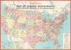
This is a large-format 1964 General Drafting map of the United States produced for Ford Times. Focusing on the country's highway infrastructure at the height of the era of interstate construction, the map highlights 'famous' restaurants adjacent to the growing American interstate system.A Closer Look
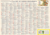
The map covers the contiguous U.S., with insets of Alaska and Hawaii (itself with an inset of Oahu), with states color-shaded for distinction. In addition to interstates, major U.S. and state highways are traced and numbered, including those under construction (dashed). Cities, national parks, major mountains, lakes, and rivers, time zone boundaries, and other features are marked. Circled numbers indicate the location of the 'famous restaurants' referred to in the title, which are listed in a large index on the verso. What exact criteria for determining which restaurants made the cut is are not clear, but some clearly were designed to cater to travelers, while others were genuinely storied local establishments. Most are no longer extant, but some remain in operation, including Lawry's The Prime Rib (Beverly Hills), the Grand Central Oyster Bar (New York), and Tavern on the Green (New York).Age of the Interstates
The construction of interstate highways in the U.S. came with the Federal-Aid Highway Act of 1956. President Eisenhower championed the project after seeing the benefits of the German Reichsautobahn while commanding Allied troops in Europe during World War II (1939 - 1945). But he also drew on his own experience of the woeful state of American highways, having been part of a U.S. Army convoy that attempted to cross the country using existing highways in 1919. The roads were so poor that it took 62 days to travel from Washington, D.C., to San Francisco. Granted, the situation was much better by the 1950s, but the economic and potential military utility of a continuous system of highways with few tolls, at a level grade, with minimal turns, and capable of handling large trucks was obvious. The wider economic situation in the 1950s also favored it, with American automobile manufacturers in peak form, gasoline cheap, and a booming economy. This era brought the Great American Road Trip to the masses and saw American car culture reach its apex.Ford Times Magazine
Launched in 1908 as a humble internal newsletter for the Ford Motor Company, Ford Times eventually evolved into a quintessential piece of Americana that fueled the nation's obsession with the open road. For much of its lifespan, this pocket-sized (initially 4 x 6 in, later 5 x 7) travelogue bridged the gap between corporate marketing and high-brow culture, famously shunning glossy photography in favor of vibrant watercolor illustrations (as seen on the title panel on the verso here) and literary contributions from talented writers and artists. Rather than just selling or celebrating Ford cars, the magazine presented a curated lifestyle guide featuring regional recipes, 'Favorite Eating Places' (or 'Favorite Restaurants' as here), and scenic driving routes that essentially mapped out the American road trip for millions of suburban families. Although the magazine officially ceased its legendary run in 1993, it remains a nostalgic goldmine for collectors and a testament to an era when a car manufacturer could double as a respected arbiter of art, travel, and leisure.Publication History and Census
This map was prepared by General Drafting in 1964 for the Ford Motor Company as a supplement to Ford Times. It is only cataloged in the OCLC among the holdings of the Newberry Library, the University of Chicago, and Bowling Green State University.Cartographer
General Drafting Corporation (1909 - 1992) was one of the 'Big Three' publishers of road maps between 1930 and 1970, along with H. M. Gousha and Rand McNally. Founded in 1909, Otto G. Lindberg, an immigrant from Finland and the company's founder, began his business with a borrowed drafting board and a $500 loan from his father. At the time only twenty-three years old, Lindberg advertised his business as 'any and all general drafting' and was based out of 170 Broadway in New York City. Only two years later, in 1911, the firm secured its first contract from the American Automobile Association to make 'road maps'. Lindberg incorporated his business in 1914 and became its first Chairman of the Board, a position he held until his death in 1968. Lindberg persuaded Standard Oil of New Jersey to let him draw the 'best' road map of the state that they had ever seen, and Standard Oil would distribute it for free. Sufficiently impressed with the finished product, Standard contracted General Drafting to make all their road maps - a relationship that lasted another six decades. This relationship allowed General Drafting to work exclusively for Standard Oil, but when oil companies stopped providing free maps, General Drafting was in a bind. The company tried to expand into the retail map market, and it of course continued creating maps for Exxon (the new name for Standard Oil) to sell, but its returns continued to decline. The firm was purchased in 1992 by Langenscheidt and subsequently absorbed into the American Map Company. General Drafting's state maps became this company's 'Travelvision' lineup. Further Details...
Condition
Good. Slight wear on original fold lines. Due to significance of verso, we have done no restoration. Overall stable.
References
OCLC 34508312.