This item has been sold, but you can get on the Waitlist to be notified if another example becomes available, or purchase a digital scan.
1862 New York Herald Map of the Florida: Fernandina and Fort Clinch
FernandinaFortClinch-nyherald-1862$175.00

Title
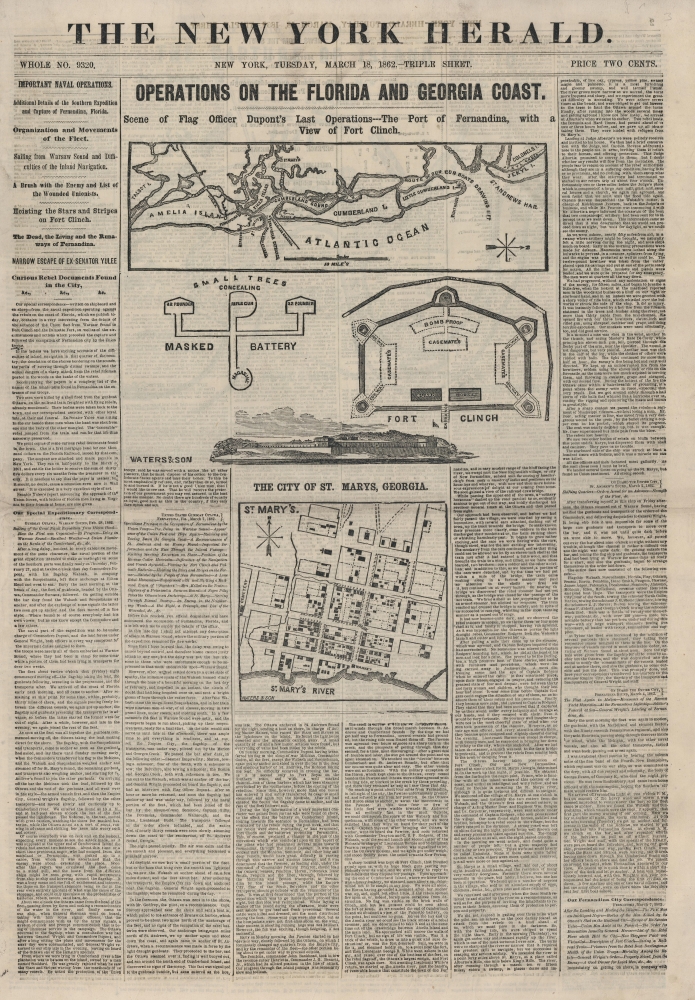
Operations on the Florida and Georgia Coast. Scene of Flag Officer Dupont's Last Operations---The Port of Fernandina, with a View of Fort Clinch.
1862 (dated) 21 x 14.5 in (53.34 x 36.83 cm)
1862 (dated) 21 x 14.5 in (53.34 x 36.83 cm)
Description
This is an 1862 New York Herald map of the coast of Florida, highlighting Amelia Island and its vicinity, celebrating the Union capture of Fernandina, Florida, and Fort Clinch.
A Closer Look
Coverage embraces coastal Florida from Talbot Island to Jekyll Island. Both Fernandina and St. Marys are illustrated and identified, as is Fort Clinch. A railroad heads inland from Fernandina. Text near Little Cumberland Island reads 'route of our gunboats drawing 11 ft'. Two diagrams of Fort Clinch appear below the map, along with a view of the fort as it appeared from the water as the Union fleet passed. A small plan of St. Marys Georgia, appears below the view of Fort Clinch.Fernandina, Florida, and Fort Clinch, during the American Civil War
In early 1862, Flag Officer Samuel Du Pont began working on a strategy to consolidate Union control of the Atlantic Coast after the successful November 1861 capture of Port Royal, South Carolina. Blockading Confederate ports and stopping Confederate blockade runners was critical to Union victory. Fernandina had critical railroad connections, making it an important port for blockade runners. Confederate General Robert E. Lee was in charge of coastal defenses in the Carolinas and Florida in late 1861 and knew the effectiveness of naval gunfire. Lee thus consolidated Confederate defenses outside gunboat range, reinforcing major centers such as Charleston and Savannah while abandoning lesser forts. Fernandina and Fort Clinch were thus evacuated in late February 1862. On hearing of hte abandonment, Du Pont dispatched Commander Percival Drayton to Fernandina just as the Confederates completed their evacuation. Union forces captured Fernandina and Fort Clinch with almost no resistance. St. Marys, Georgia, just up the St. Marys River, fell to the Union soon after. Du Pont reported 'full possession of Cumberland Island and Sound, of Fernandina and Amelia Island, and of the river and town of St. Mary's' on March 4, 1862.Fort Clinch
Fortifications were first constructed where Fort Clinch stands in 1736, during the Spanish Period, to protect the St. Marys River and Cumberland Sound. Construction of what became Fort Clinch began in 1847 as part of the Third System of coast fortifications planned after the War of 1812. (The fort was named after General Duncan Lamont Clinch, a veteran of the War of 1812 and the First and Second Seminole Wars, following his death in 1849.) By 1861, at the outbreak of the U.S. Civil War (1861 - 1865), Fort Clinch was only 2/3 complete. In late February 1862, as Union forces consolidated control of the coastal regions of Georgia, General Robert E. Lee ordered Fort Clinch evacuated. The Union Army occupied the fort early in March and held it for the remainder of the war. Afterward, Fort Clinch fell into disuse and was maintained by the U.S. Army on caretaker status. The fort regained importance with the outbreak of the Spanish-American War in 1898. However, since that war lasted less than a year, the fort was quickly abandoned again. The Army sold the fort to private entities in 1926, and it became one of Florida's first state parks in 1935. In 1936, the Civilian Conservation Corps began restoring the fort and built roads, the campground, and the museum. The fort passed back into active service during World War II, operating as a center for surveillance and communications. It was given back to the state of Florida not long after the end of the war, and today, it is a Florida state park.Page 2: The Capture of Island No. 10
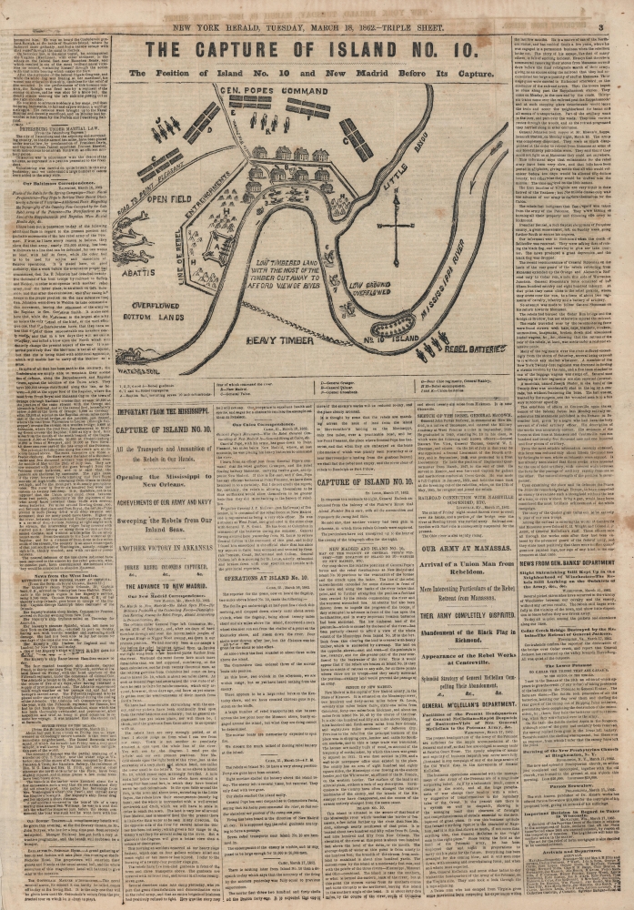
A map illustrating the Capture of Island No. 10 and New Madrid appears at the top of Page 2. Island No. 10 was a fortified island on the Mississippi upriver from New Madrid, Kentucky. This region, collectively known as the Kentucky Bend, is situated at the meeting point of Missouri, Kentucky, and Tennessee. The Confederate Army fortified the island, realizing that if they could control Island No. 10, they could effectively prevent Union forces from using the Mississippi as a gateway to the Deep South. Union General John Pope came up with an ingenious solution: build a canal through the bayous east of New Madrid to reconnect with the Mississippi between Island No. 8 and Island No. 9. This allowed Pope to position troops on both sides of the river, laying siege to Island No. 10, and neutralizing its strategic importance. Confederate forces on Island No. 10 surrendered on April 8, 1862, a few weeks after this newspaper hit newsstands in New York. For a more complete description of the Battle of Island No. 10, see Geographicus newmadridisland10-wardept-1862.Publication History and Census
This map was created by Waters and Son and published by the New York Herald on the front page of the March 18, 1862 edition. We have been unable to locate any cataloged examples in institutional collections and are aware of only one other instance when this map appeared on the private market.Condition
Very good. Newsprint. Front page separated from rest of paper.