This item has been sold, but you can get on the Waitlist to be notified if another example becomes available, or purchase a digital scan.
1906 De Lacy Broadside Map of the World Promoting Travel to Australia
FHSLines-delacy-1906$1,250.00

Title
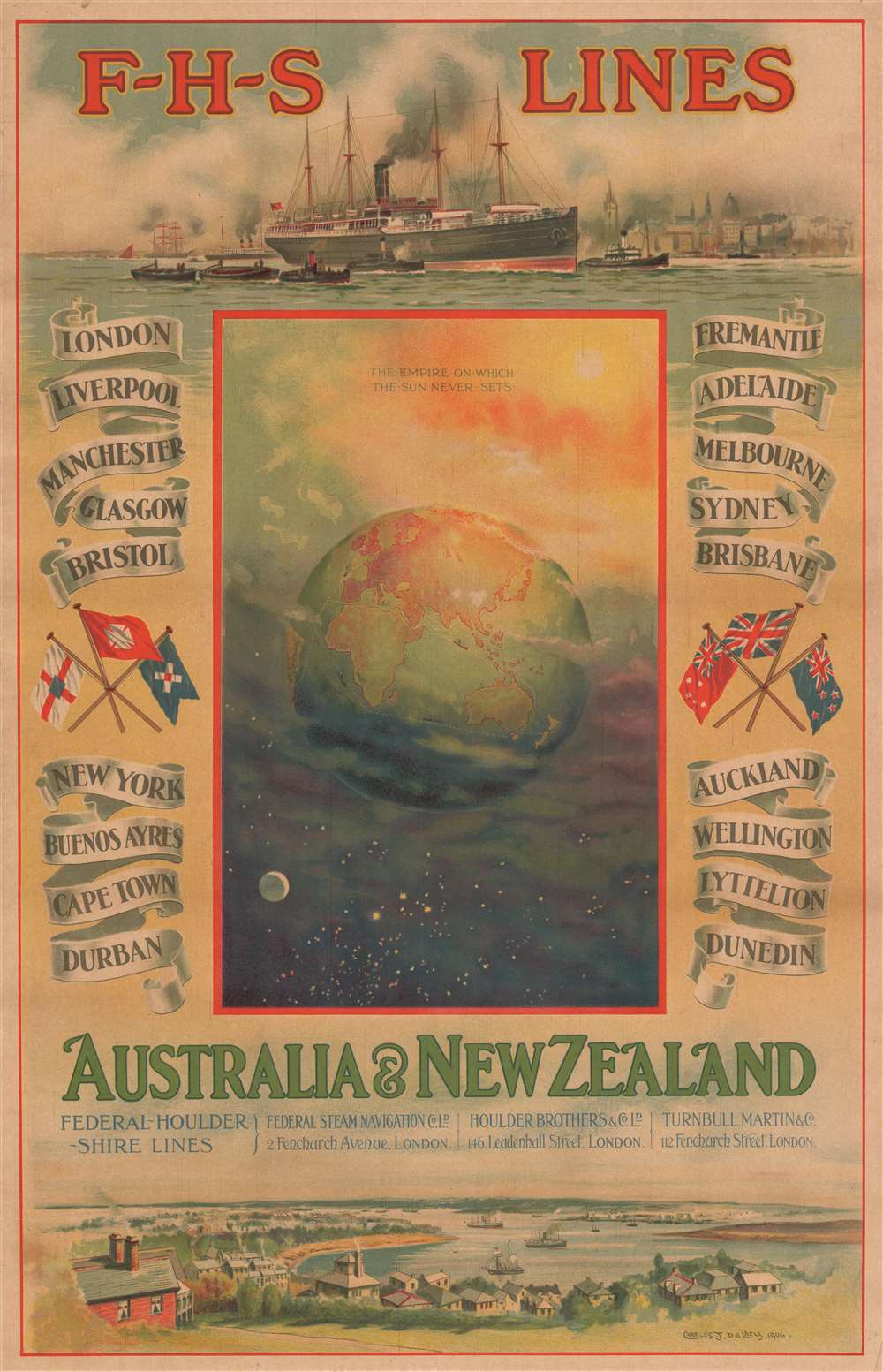
F-H-S Lines Australia and New Zealand.
1906 (dated) 36.75 x 23.75 in (93.345 x 60.325 cm)
1906 (dated) 36.75 x 23.75 in (93.345 x 60.325 cm)
Description
This is a 1906 Charles John de Lacy broadside travel poster and map of the world promoting travel to Australia and New Zealand. The Earth occupies the center of the broadside, with the Moon and night to the bottom left and the Sun and daytime to the upper right accompanied by the phrase 'the empire on which the Sun never sets'. Steamships are illustrated traversing the world's oceans, with faint white dotted lines tracing the routes they follow. The names of cities throughout the world are printed on banners to the left and right of this central image of the cosmos, with cities in the United Kingdom situated on the upper left and in the Americas and Africa on the bottom left. Australian cities, including Adelaide, Melbourne, and Sydney, are on the upper right, while cities in New Zealand, with Auckland and Wellington among them, in the lower right. The top of the broadside is adorned by a wonderful illustration of a steamship, most likely a passenger liner, being maneuvered through a harbor by two tugboats. A lovely harbor view decorates is included along the bottom of the broadside.
Federal-Houlder-Shire Lines
Federal-Houlder-Shire Lines was formed in 1904 following the merger of the Federal Steam Navigation Company, Houlder Brothers and Company, and the Scottish Shire Line owned by Turnbull, Martin and Company. The joint company only existed until 1912 when Federal was taken over by the New Zealand Shipping Company and Houlder withdrew from the arrangement. Federal and Shire continued the partnership until it was dismantled at the outbreak of World War I.Chromolithography
Chromolithography is a color lithographic technique developed in the mid-19th century. The process involved using multiple lithographic stones, one for each color, to yield a rich composite effect. Oftentimes, the process would start with a black basecoat upon which subsequent colors were layered. Some chromolithographs used 30 or more separate lithographic stones to achieve the desired effect. Chromolithograph color could also be effectively blended for even more dramatic effects. The process became extremely popular in the late 19th and early 20th centuries, when it emerged as the dominate method of color printing. The vivid color chromolithography produced made it exceptionally effective for advertising and propaganda imagery.Publication History and Census
This broadside was created by Charles John de Lacy and for Federal-Houlder-Shire Lines in 1906. This is the only known example.Cartographer
Charles John de Lacy (1856 - December 13, 1929) was an artist, painter, and press artist and one of the most celebrated maritime artists of his day. Born in Sunderland, County Durham, de Lacy is particularly well-known for his works that picture warships. He was also regularly commissioned by shipbuilders to compose promotional pieces for their firms. Works by him are part of the collections at the National Maritime Museum, the Tyne and Wear Archives and Museums, the Russel-Cotes Art Gallery and Museum, and the Cowes Maritime Museum, among others. De Lacy married Alice Harriet Hill in 1880 in London, with whom he had two daughters. More by this mapmaker...
Condition
Very good. Even overall toning. Closed margin tear professionally repaired on verso. Blank on verso.