This item has been sold, but you can get on the Waitlist to be notified if another example becomes available.
1960 Pictorial Map of the United States / 1960 Presidential Election Fact Sheet
FiftyUnitedStates-thompson-1960$150.00

Title
The 50 United States of America. / Election Map and 1960 Presidential Fact Sheet.
1960 (dated) 18.25 x 25.25 in (46.355 x 64.135 cm) 1 : 7510800
1960 (dated) 18.25 x 25.25 in (46.355 x 64.135 cm) 1 : 7510800
Description
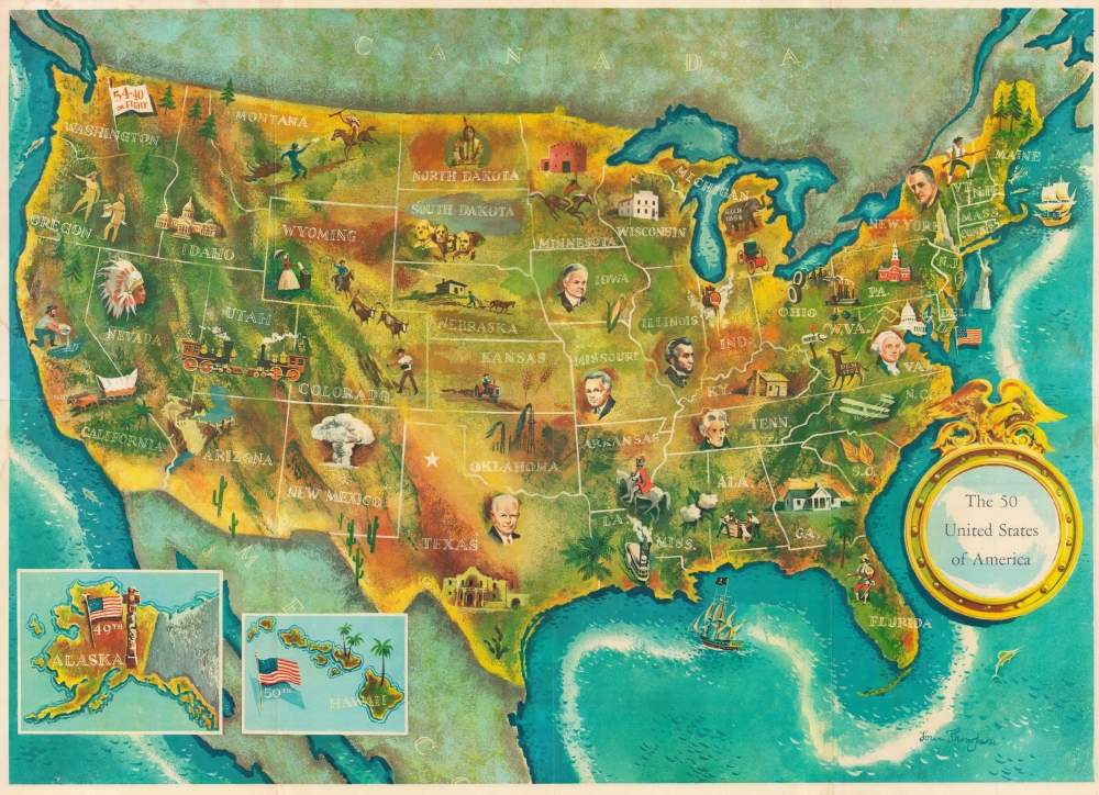
This is a 1960 Lorin Thompson pictorial map of the United States issued just before the 1960 presidential election. It is one of the earliest pictorial maps of the United States to include all 50 states - following the August 1959 admission of Hawaii.
A Closer Look - Pictorial Map of All 50 States
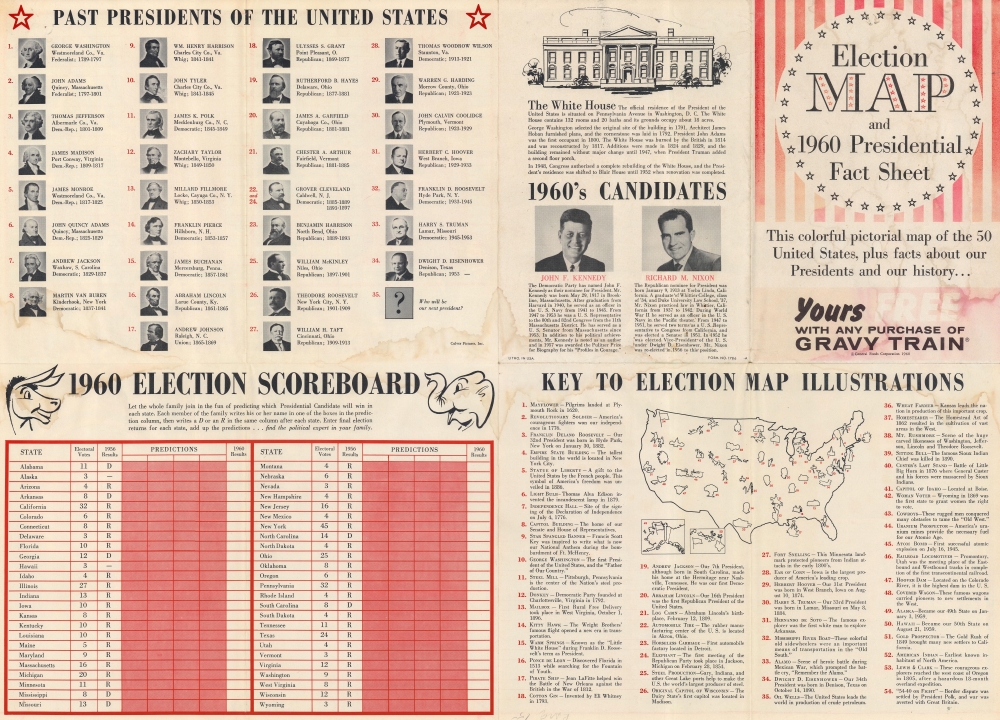
Coverage embraces the continental United States, with Alaska and Hawaii included via insets in the lower left. A portrait or vignette illustrates each state. Likenesses of significant figures appear throughout, including George Washington, Abraham Lincoln, Franklin D. Roosevelt, Dwight Eisenhower, Lewis and Clark, and Sitting Bull. Vignettes illustrating the horseless carriage (the first car), the transcontinental railroad, Hoover Dam, and the atomic bomb highlight American ingenuity. Others, such as a gold prospector, a homesteader, and a soldier from the American Revolution, focus on history. The verso features an index of the illustrations and election content.The Verso: 1960 Presidential Election, Kennedy v. Nixon
This piece was printed during the 1960 presidential contest between John F. Kennedy and Richard Nixon. The verso includes information on the White House and candidate biographies. A list of past presidents provides their portraits, hometowns, parties, and dates in office. A '1960 Election Scoreboard' is included to help readers follow and predict the election's outcome. States are listed alphabetically, along with the number of electoral votes they held, and which party they voted for in 1956.Publication History and Census
This map was created by Lorin Thompson and published in 1960 by the General Foods Corporation. We note two examples cataloged in OCLC: Osher Map Library at the University of Southern Maine and Baylor University.Cartographer
Lorin Thompson (1911 - 1997) was an American artist and muralist. He is best known for his murals in the U.S. Post Office in Altoona, Pennsylvania, which he created as a project for the Works Progress Administration in 1938. One, entitled Pioneers of Altoona, depicts early settlers building a railroad track, and the other, Growth of the Road, contains images of daily life in Altoona. Another of his murals hangs in the post office in Mercer, Pennsylvania, while a third was commissioned for the Pascagoula, Mississippi post office. The Pascagoula piece was completed in 1939 and, entitled Legend of the Singing River illustrates a local folktale about a tribe of Native American who chose to go into the river and eventually drown instead of facing the wrath of an enemy tribe. This mural was restored in the 1960s when the building became the Pascagoula Public Library. Hurricane Katrina damaged the building in 2005 and the mural was placed in storage. It was re-installed in the newly established Pascagoula Post Office in 2010. Thompson was also the creator and illustrator of the character Ranger Rick for the National Wildlife Federations children's magazine 'Ranger Rick'. More by this mapmaker...
Condition
Good. Wear along original fold lines. Dampstaining. Text on verso concerning 1960 presidential election.
References
OCLC 660052801.