This item has been sold, but you can get on the Waitlist to be notified if another example becomes available, or purchase a digital scan.
1945 WWII Route Map of B Company, 692nd Tank Destroyer Battalion in Europe
FightinBCo692TDBat-unknown-1945$400.00

Title
Fightin' 'B' Company 692 T.D. Bn.
1945 (undated) 18 x 22.5 in (45.72 x 57.15 cm)
1945 (undated) 18 x 22.5 in (45.72 x 57.15 cm)
Description
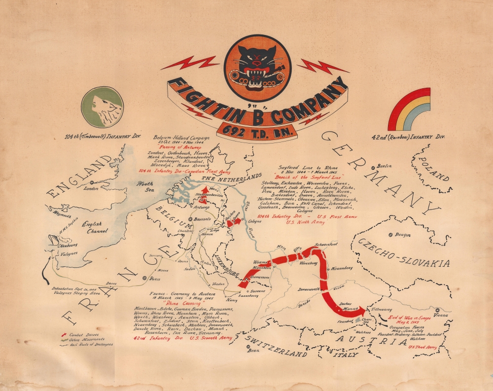
This is a c. 1945 World War II unit route map of Company B, 692nd Tank Destroyer Battalion, in Europe. The map follows Company B from its September 26, 1944 debarkation in Europe through France, Belgium, and Germany until May 8, 1945, V-E Day, the end of the war in Europe.
A Closer Look
A green line approximates the Company's movements across northern France and Belgium to its first engagement, the Belgium - Holland Campaign (October 23, 1944 - November 8, 1944). Cities and towns liberated are listed along with major landmarks, such as the Mark and Maas Rivers. The two units the 692nd was attached to, the 104th Infantry Division and the Canadian First Army, are referenced. From here, the Company fought from the 'Siegfried Lin(e to [the] Rhine' November 8, 1944 - March 7, 1945). As with the previous campaign, cities, towns, and major landmarks are listed, and the three units to which it was assigned (the 104th Infantry Division, the U.S. First Army, and the U.S. Ninth Army) are referenced. After this campaign, Company B and the 692nd were transferred south and fought from France through Germany to Austria (March 18, 1945 - May 9, 1945). During these few months, the Company crossed the Rhine River, an important moment in the war for many soldiers. When the war ended, on May 8, 1945, the Company was outside Tittmoning, Germany, and spent the next few months on Occupation Duty in Germany and Austria.World War II Route Maps
Maps tracing a unit's movements during World War II were created by American and British units both during and after the war. As a genre, these maps represent a wide range of aesthetics, from the purely functional, limited to places and dates, to the artistic, even comic. Many combine the two and provide a visually striking and historically informative summary of the unit's experiences.Publication History and Census
This map was drawn by an unknown artist and published c. 1945. This is the only known cataloged example. We are aware of one other example in private hands.Condition
Good. Even overall toning. Some dampstaining along bottom edge.