This item has been sold, but you can get on the Waitlist to be notified if another example becomes available, or purchase a digital scan.
1840 Wilkes Map of the Fiji Islands
FijiFeeJee-wilkes-1840$600.00

Title
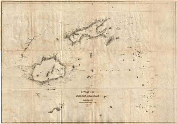
Chart of the Viti Group or Feejee Islands by the U.S. Ex. Ex.
1840 (dated) 24 x 34.5 in (60.96 x 87.63 cm) 1 : 710000
1840 (dated) 24 x 34.5 in (60.96 x 87.63 cm) 1 : 710000
Description
A beautiful example of Wilkes' 1840 map of the Fiji Islands. Considered to be the first accurate map of the Fiji Islands, this map includes three main islands, Vanua Levu, Viti Levu, and Taveuni as well as the Yasawa Group and countless lesser islands. Topography is rendered by hachure and shoals, reefs, and other undersea dangers are indicated with shading.
A survey of faraway and little known Fiji, then known as the Cannibal Islands for the ferocity of its indigenous population, may seem an odd goal for an expedition funded by the U.S. Government, but completing it was in fact one of the primary stated objectives of the U.S. Ex. Ex. The Fiji islands were, at the time, the world's largest source of beche-de-mere, or sea slugs. Properly cured sea slugs were a considered a culinary delicacy in China where they fetched extraordinary prices. In the early 19th century the Fijian sea slug trade was largely dominated by merchant captains operating out of Salem, Massachusetts. In the twelve years prior to the launch of the U.S. Ex. Ex. eight ships, five of which hailed from Salem, wrecked on Fiji's little known reefs. The value of this risky trade prompted the United States government to step in and command a detailed reconnaissance. Wilkes had a particularly difficult time surveying the Fijian archipelago and lost several of his most valued me to the aggressive and highly territorial islanders. It was here, in retribution for an deadly attack on several of his most trusted sailors, that Wilkes reached the moral low point of his career when he commanded the Malolo Massacre. Eighty Fijians were slain.
This map was prepared by Charles Wilkes and engraved by J. H. Young and Sherman & Smith. Despite being dated 1841, and copyrighted in 1844, it was first published by Lea & Blanchard of Philadelphia to illustrate the atlas volume of the 1845 first edition of Wilkes' official U. S. Ex. Ex. Report.
Collectors will note that most of the maps from Wilkes' official report of the U.S. Exploring Expedition were issued in small and large formats. This is the large format edition and is exceptionally scarce. The full run consisted of only 150 presentation copes and 100 official copies. Twenty-five of these are known to have been lost in a fire, leaving only 225 possible examples.
CartographerS
Charles Wilkes (April 3, 1798 – February 8, 1877) was an American naval officer and explorer. Wilkes was born in New York City to a prominent family. His mother died when he was just three years old. Consequently, Wilkes was raised by his aunt Elizabeth Ann Setton, the first American born woman to be canonized a saint of the Roman Catholic Church. Inspired by tales of nautical adventure, Wilkes embarked on several merchant voyages, including one to the South Pacific. Finding shipboard life unpleasant, he returned to New York City where attended Columbia College (today's Columbia University) studying various aspects of mathematics and the sciences. For a time Wilkes was a prodigy of Coast Survey Superintendent Ferdinand Hassler. Before the relationship went foul, Wilkes mastered Hassler's sophisticated techniques for navigation and nautical surveying. Though the Coast Survey at this time was underfunded, several coastal mapping expeditions were launched, one of which focused on Narragansett Bay and was headed by Wilkes. In 1833, impressed with his work on Narragansett Bay, the Navy placed Wilkes in charge of the Navy's Depot of Charts and Instruments in Washington, D.C, out of which developed the Naval Observatory and Hydrographic Office. In 1838, after years of political posturing, he was chosen to lead the U.S. Exploring Expedition (U.S. Ex. Ex.), a multidisciplinary voyage to the Pacific with the lofty goal to
collect, preserve, and arrange every thing valuable in the whole range of natural history, from the minute madrapore to the huge spermaceti, and accurately describe that which cannot be preserved.The expedition lasted from 1838 to 1842. Wilkes gained the reputation for being a harsh and dictatorial leader often at odds with his sailors and sub commanders - so much so that some suggest he was the real life inspiration for Herman Melville's characterization of Captain Ahab. Nonetheless, the U.S. Ex. Ex. was a resounding success with long term political and scientific ramifications. Under Wilkes, the expedition surveyed 1500 miles of the Antarctic continent, mapped over 280 islands, explored over 800 miles of the Pacific Northwest, and catalogued over 60,000 plant and bird specimens. Despite his scientific achievements, the end of the expedition Wilkes was court-martialed for the loss of one of his ships on the Columbia River, for the regular mistreatment of his subordinate officers, and for excessive punishment of his sailors. He was acquitted on all charges except illegally punishing the men in his squadron. During this post-expedition period he was also employed by the U.S. Coast Survey, but it was mostly an honorary position with most of his energies being focused on preparing the influential five volume expedition report. Later, during the American Civil War (1861 - 1865) Wilkes commanded a Union naval vessel in the Trent Affair, a diplomatic incident in which Wilkes intercepted the British mail packet RMS Trent and removed, as contraband of war, two Confederate diplomats, James Mason and John Slidell. Wilkes died in Washington, D. C. on February 8, 1877 at the rank of Rear Admiral. In August 1909, the United States moved his remains to Arlington National Cemetery. His gravestone reads "he discovered the Ant-arctic continent". More by this mapmaker...
Sherman and Smith (fl. c. 1829 - 1855), sometimes working as Stiles, Sherman & Smith, were American engravers active in New York City during the middle part of the 19th century. The firm including John Calvin Smith (surveyor and engraver), George E. Sherman, and sometimes, Samuel Stiles. Their work primarily focused on government publications, including the maps and engravings prepared to illustrate the official records of the 1838-42 United States Exploring Expedition (U.S. Ex. Ex.), maps issued for the Army Corps of Topographical Engineers, and various U.S. Coast Survey Charts. They also engraved privately for Thomas Bradford and John Disturnell, among others. Sherman and Smith maintained offices at the corner of Broadway and Liberty Street in New York City and were highly regarded as the finest cartographic engravers in the city. Their non-cartographic legacies include George Inness, who apprenticed with them for two years before going on to become a well regarding American landscape painter of the Hudson River School. Learn More...
Source
Wilkes, C., Atlas. Narrative of the United States Exploring Expedition During the Years 1838, 1839, 1840, 1841, 1842, (Philadelphia: Lea & Blanchard) 1845.
Condition
Very good. Backed with linen as issued. Overall toning. Some wear on original fold lines. As in most examples, lower left margin partially trimmed to neat line.
References
Rumsey 4442.003. Cowan I, pp. 248-249n. Cowan II, p. 683. Ferguson, Australia 4209. Forbes, D. W., Hawaiian National Bibliography 1780 - 1900: 1831-1850, 1573. Hill (II) #1866. Howes W414. Rosove, Antarctica 353. Streeter Sale 3324.