This item has been sold, but you can get on the Waitlist to be notified if another example becomes available, or purchase a digital scan.
1900 Tarchi and Pineider Pictorial City Map or Plan of Florence, Italy
FirenzeMonumentale-tarchi-1900$300.00

Title
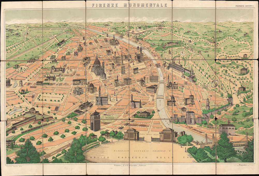
Firenze Monumentale.
1900 (undated) 19 x 28 in (48.26 x 71.12 cm)
1900 (undated) 19 x 28 in (48.26 x 71.12 cm)
Description
This is a c. 1900 Emilio Tarchi pictorial tourist map of Florence, Italy highlighting the historic city's most iconic buildings. Beautifully rendered, the map depicts the city from the Piazza Cavour to the Porta Romana and from the Viale Michelangiolo to the Piazzale Vittorio Emanuele II. The Cathedral of Santa Maria del Fiore, the Basilica of Santa Croce, and the Palazzo Vecchio are only a few of Florence's celebrated architecture illustrated here. Numerous other buildings are illustrated in a cadastral manner, including the Uffizi Gallery next to the Palazzo Vecchio and the Ponte Vecchio. Others, like the Museum of Natural History, are simply labeled. Roads and plazas throughout the city are identified, including those in the parks surrounding the city.
Publication History
This map was drawn by Emilio Tarchi and published by Giuseppe Pineider c. 1900. We are aware of at least two different editions of this map, with the second appearing much like the current example, only with the addition of Florence's tramways.Cartographer
Giuseppe Pineider (fl. c. 18?? - 19??) was an Italian publisher active in Florence during the late 19th and early 20th century. More by this mapmaker...
Condition
Good. Dissected and mounted on linen in eighteen panels. Wear along original fold lines. Verso reinforcements along original fold lines. Text on verso.
References
OCLC 1004638786.