
This item below is out of stock, but another example (left) is available. To view the available item, click "Details."
Details
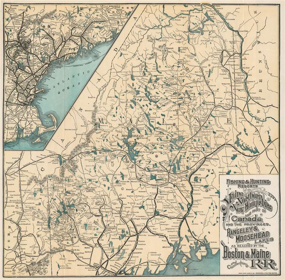
1899 'Boston and Maine R.R. Map' of Maine and New Hampshire Hunting Resorts
$350.00
1899 'Boston and Maine Railroad Map' of Maine and New Hampshire Hunting
FishingHuntingResorts-randavery-1899$175.00

Title
Fishing and Hunting Resorts of Maine, Northern New Hampshire, and Part of Canada and the Provinces, Rangeley and Moosehead Lakes as Reached by the Boston and Maine Railroad and Connections.
1899 (undated) 14.5 x 14.75 in (36.83 x 37.465 cm) 1 : 630000
1899 (undated) 14.5 x 14.75 in (36.83 x 37.465 cm) 1 : 630000
Description
This is an 1899 Rand Avery Supply Company and Boston and Maine Railroad map of Maine and northern New Hampshire. Depicting the region from the White Mountains northeast to New Brunswick, thick black lines trace the Maine Central Railroad's route. Less imposing black lines illustrate the region's other railroads, including the 'Canadian Pacific Railroad' and the 'Bangor and Aroostook Railroad'. Maine's many lakes, such as Moosehead Lake, Chamberlain Lake, the Eagle Lakes, and Grand Lake, are illustrated and labeled, along with the region's many rivers. Houses, hotels, and other properties catering to outdoor sports enthusiasts are identified, although they are not emphasized. An inset in the upper left promotes the railway network between Boston and Vanceboro, Maine, with spur service to the Mount Desert Island Ferry and numerous lines running through the White Mountains.
Boston and Maine Railroad
Commonly known as the 'B and M', the Boston and Maine Railroad was chartered in New Hampshire on June 27, 1835. The firm consolidated several smaller companies, including the Andover and Haverhill Railroad and later the Boston and Portland Railroad. It merged with the Maine, New Hampshire and Massachusetts Railroad in 1842, but retained the Boston and Maine operating name. In the subsequent decades it acquired or leased several other railroads, including the Boston and Lowell (1887), Northern (1884), Connecticut River (1893), Concord and Montreal (1887), and Fitchburg (1900). In 1910 it was acquired by J. P. Morgan and his New York, New Haven and Hartford Railroad. The firm initially prospered on the development of mill towns throughout New England and later capitalized on tourism from urban centers in Boston and New York. Nonetheless, the railroad went through a decline during the Great Depression and subsequently, when most of the old textile mills closed. Part of the Boston and Maine network remain in operation today under the Pan Am Railways (PAS) brand.Publication History and Census
This map was created by the Rand Avery Supply Company and published by the Passenger Department of the Boston and Maine Railroad in the second edition of Boston and Maine Railroad. Summer Excursions to the White Mountains, Mount Desert, Montreal and Quebec, Winnepesaukee, Memphremagag, Rangleley and Moosehead Lakes, and the New England Beaches. Routes, Rates, Maps, Hotel and Boarding-House List, etc., etc. in 1899. An example of the map is cataloged in OCLC and is part of the institutional collection at Harvard University.Cartographer
Rand, Avery, and Company (1851 – 1886) was a Boston based book and map printer active in the late 19th century. The company was founded in 1851 by George Curtis Rand (December 13, 1819 – December 30, 1878) and his brother-in-law Abraham Avery (November 15, 1824 - April 3, 1893). George C. Rand was a brother to William H. Rand of Rand, McNally, and Company of Chicago. George C. Rand was born in Woodstock, Vermont, to Baptist minister John Rand (1781 – 1855) and his wife. Rand began working in the printing industry from at least the 1840s, wherein he mostly produced religious tracts. He married Julia Avery in 1851 and brought his brother-in-law, Abraham Avery, into the business, renaming the firm Rand, Avery, and Company. Avery was born in Wibraham, Massachusetts and studied at Wesleyan University, which his father helped to found. Rand, Avery, and Company was based in Cornhill, Boston, and was, for a time, they were the largest printers in New England. Such works as Uncle Tom's Cabin were included in their catalog. Avery retired when Rand died in 1878, but the firm continued to publish under another generation of managers, including Rand's son, Avery L. Rand, until at least 1886. They also took on a fourth partner, Orrin F. Frye, and published as Rand, Avery, and Frye. After retiring Avery moved to Los Angeles where he died in 1893. It appears that this firm also published under the name the Rand Avery Supply Company. More by this mapmaker...
Condition
Very good. Exhibits light wear along original fold lines. Left margin extended. Blank on verso.
References
OCLC 57456470.