This item has been sold, but you can get on the Waitlist to be notified if another example becomes available, or purchase a digital scan.
1936 Richard Edes Harrison Map of Japan
FiveJapans-harrison-1936$125.00

Title
Five Japans.
1936 (undated) 14 x 22.25 in (35.56 x 56.515 cm)
1936 (undated) 14 x 22.25 in (35.56 x 56.515 cm)
Description
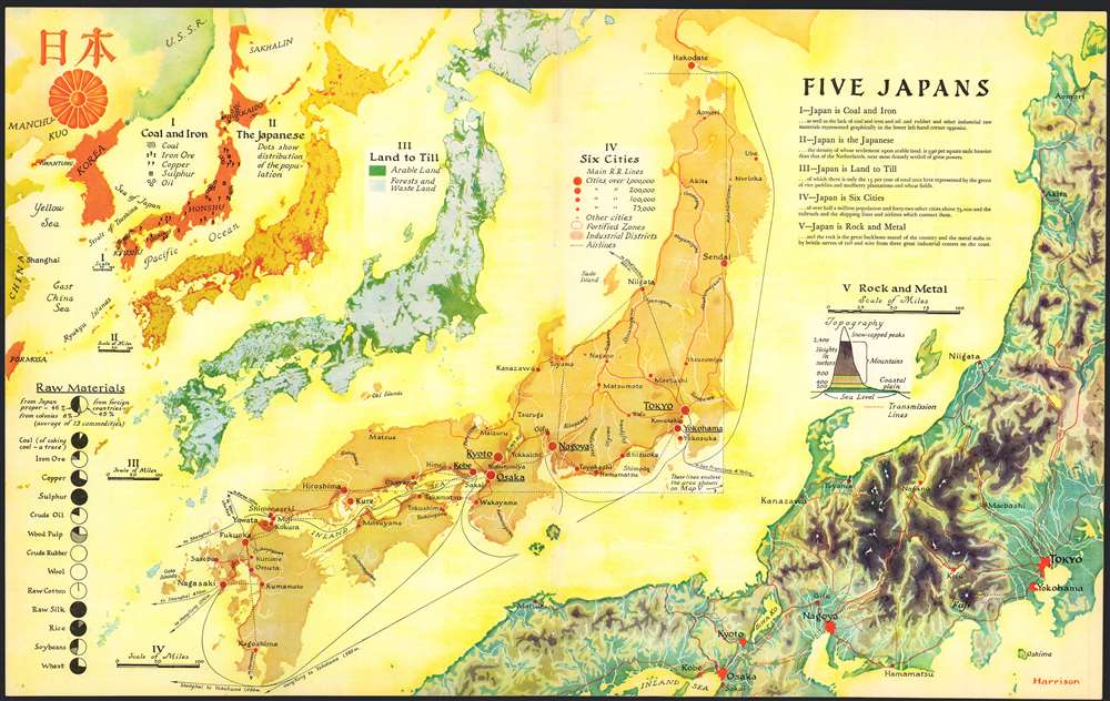
This 1936 Richard Edes Harrison map of Japan - really, five separate maps of Japan on a single sheet – is one of the graphic artist Harrison's first published forays in cartography, and is a superb representation of his skill at the visual display of quantitative information. Accompanying an article describing Japan's pre-war industrial powerhouse, this combination of maps uses bright color in Harrison's inimitable style to clearly present a layered picture of Japan, her people, and her industries. The five maps fan out across the page in a visually arresting composition.
I: Coal and Iron
In what is physically the smallest of the maps, Harrison uses a key to show the sources of Japan's key industrial resources. The map is supplemented with an array of pie charts showing the balance of what resources Japan produced domestically and those which were imported. Perhaps more importantly, this is the one map on this sheet which a) places Japan physically in a broader geographical context with Korea, China and the U.S.S.R. and b) directly makes reference to Japan's expansionism: the deep orange coloring the Japanese Islands is also applied to Formosa, Kwantung, Korea, and the southern half of Sakhalin Island.II: The Japanese
The next map uses red dots on a mustard background to indicate the distribution of Japan's population, 'the density of whose settlement upon arable land is 590 square mile heavier than that of the Netherlands.' Comparing this map to the next shows the high correlation between Japan's population and her cultivable land.III: Land to Till
Combined with the previous map, this one highlights one of the great pressures on Japan: the density of her population, and the constraint of a relatively small area available for farming.IV: Six Cities
This map highlights Japan's urban centers, the railways connecting them, and the distances to Shanghai, Hong Kong, Vladivostok, and remote San Francisco.V: Rock and Metal
This map focuses on Honshu, and in particular the mountainous spine of that main Japanese Island. It details the arteries connecting Tokyo, Nagoya, Kyoto and Osaka, as well as the railways and telephone/telegraph lines crossing the mountains to the northern cities. A color-key emphasizes the sharp changes in elevation in Japan's massif, and (again, in comparison with the other maps) shows the concentration of Japan's population in lowlands near the coast, in conjunction with Japan's farmlands.Publication History and Census
This map was printed in a single edition for inclusion in the September, 1936 issue of Fortune Magazine and is one of the earliest of Richard Edes Harrison's cartographic contributions to that publication. While collected runs of Fortune can be found in institutional collections, this individual map is not cataloged in OCLC and it has been largely neglected by the trade.Cartographer
Richard Edes Harrison (1902 - January 5, 1994) was an American cartographer and cartoonist active in the middle part of the 20th century. Harrison is credited with redefining cartography, especially journalistic cartography, by employing spherical perspective, bold shading, and graphic design to both make maps more publicly accessible and give them an artistic dimension. Harrison was born in Baltimore and studied design at Yale, graduating in 1923, before relocating to New York City at the height of the Great Depression. He made ends meet through industrial design work, creating everything from bottles to ashtrays. His first foray into the cartographic world was a fill-in job at Fortune magazine. The editors at Fortune must have admired his work for it launched a long-standing collaboration. His work, doubtless inspired by the age of air travel, became exceptionally popular during World War II, where his unique approach and political charged subject matter illustrated the seats of war with exceptional poignancy and clarity. After the war, Harrison continued to produce maps from his base in New York City. In his spare time he was an avid ornithologist and was commonly seen in Central Park in search of rare bird sightings. More by this mapmaker...
Condition
Very good condition. Thread holes as always with this map, but no loss or dogears.
References
Rumsey 13204.000. Not in OCLC.