This item has been sold, but you can get on the Waitlist to be notified if another example becomes available, or purchase a digital scan.
1756 Bellin Separate Issue Flag Chart
FlagChart-bellin-1756$975.00

Title
Tableau des Pavillons Que la PulPart des Nations Arborent a La Mer.
1756 (dated) 20 x 24 in (50.8 x 60.96 cm)
1756 (dated) 20 x 24 in (50.8 x 60.96 cm)
Description
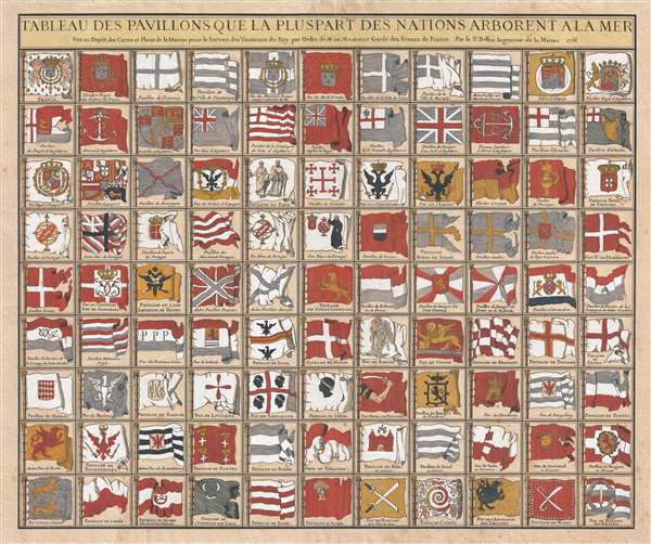
One of the most beautiful and interesting separate issue flag charts we have found, this stunning chart by Jacques Nicolas Bellin was issued in 1756, at the opening of the French and Indian War or Seven Years War (1756 - 1763). The flags represented are unusually large and beautifully engraved. Moreover, this chart, as a separate issue, exhibits no evidence of having been bound into a book or atlas.
This chart's most historically significant element is its illustration of the ephemeral New England Globe Flag, one of the earliest New England flags and in fact one of the earliest examples of a fully American flag. This flag and its appearance on this chart is described in the Rhode Island Historical Society Collections (January 1930, Volume XXIII, page 97):
In the lower row, the flag of Empire of China (Sina) stands out. It appears as a great whirlpool surrounded by eight decorations. This is most likely based upon an image of the Chinese flag appearing in Carel Allard's, 1705 Dutch flag book, Niewe Hollandse Scheeps Bouw. In fact, it is a misinterpretation of the Qing flag, a dragon on a yellow field with eight banners. Nonetheless, Bellin, likely having never seen a Chinese flag, interpreted the dragon to the best of his ability.
Other fags pf interest include the flag of the pope, a curious Portuguese flag bearing a priest, the flags of various trading companies, the Flag of the Tartars (dragon), and the arm and saber banner of Poland.
This chart's most historically significant element is its illustration of the ephemeral New England Globe Flag, one of the earliest New England flags and in fact one of the earliest examples of a fully American flag. This flag and its appearance on this chart is described in the Rhode Island Historical Society Collections (January 1930, Volume XXIII, page 97):
The first dated reference to the globe flag seems to be in the 'Schouw-Park aller Scheeps-Vlaggen' or 'Tableau des Pavilions de Mer,' which was published by Pieter Schenk at Amsterdam in 1711. The New England flag is shown hand colored and with the colors also shown by tincture lines, as a blue flag, having a white canton with a red cross and with a globe on a standard in the first quarter of the canton. The globe is outlined in black, but no color is specified. No reference to this globe flag has been found in any contemporary English or American writings…New England had several early flags. The earliest, was the flag of the Massachusetts Bay Colony, a white canton on a red field, of which there are no surviving illustrations. The flag changed c. 1686 to include St. George's Cross and a pine or oak tree in the upper left quadrant. The oak tree was reinterpreted as a globe and the field changed to blue around 1711, when this chart was issued, making one of the earliest, if not the first, printed illustration of the Globe Flag of New England.This chart features several other rarely seen flags, including the flags of the VOC and WIC, important Dutch merchant trading companies located at left center. Although private commercial ventures, these companies had the military and financial power of independent nations and were often treated as such.
In the lower row, the flag of Empire of China (Sina) stands out. It appears as a great whirlpool surrounded by eight decorations. This is most likely based upon an image of the Chinese flag appearing in Carel Allard's, 1705 Dutch flag book, Niewe Hollandse Scheeps Bouw. In fact, it is a misinterpretation of the Qing flag, a dragon on a yellow field with eight banners. Nonetheless, Bellin, likely having never seen a Chinese flag, interpreted the dragon to the best of his ability.
Other fags pf interest include the flag of the pope, a curious Portuguese flag bearing a priest, the flags of various trading companies, the Flag of the Tartars (dragon), and the arm and saber banner of Poland.
Cartographer
Jacques-Nicolas Bellin (1703 - March 21, 1772) was one of the most important cartographers of the 18th century. With a career spanning some 50 years, Bellin is best understood as geographe de cabinet and transitional mapmaker spanning the gap between 18th and early-19th century cartographic styles. His long career as Hydrographer and Ingénieur Hydrographe at the French Dépôt des cartes et plans de la Marine resulted in hundreds of high quality nautical charts of practically everywhere in the world. A true child of the Enlightenment Era, Bellin's work focuses on function and accuracy tending in the process to be less decorative than the earlier 17th and 18th century cartographic work. Unlike many of his contemporaries, Bellin was always careful to cite his references and his scholarly corpus consists of over 1400 articles on geography prepared for Diderot's Encyclopedie. Bellin, despite his extraordinary success, may not have enjoyed his work, which is described as "long, unpleasant, and hard." In addition to numerous maps and charts published during his lifetime, many of Bellin's maps were updated (or not) and published posthumously. He was succeeded as Ingénieur Hydrographe by his student, also a prolific and influential cartographer, Rigobert Bonne. More by this mapmaker...
Condition
Very good. Light overall toning.