1720 Chatelain Chart of the World's Flags and Naval Ensigns
FlagChart-chatelain-1720$950.00

Title
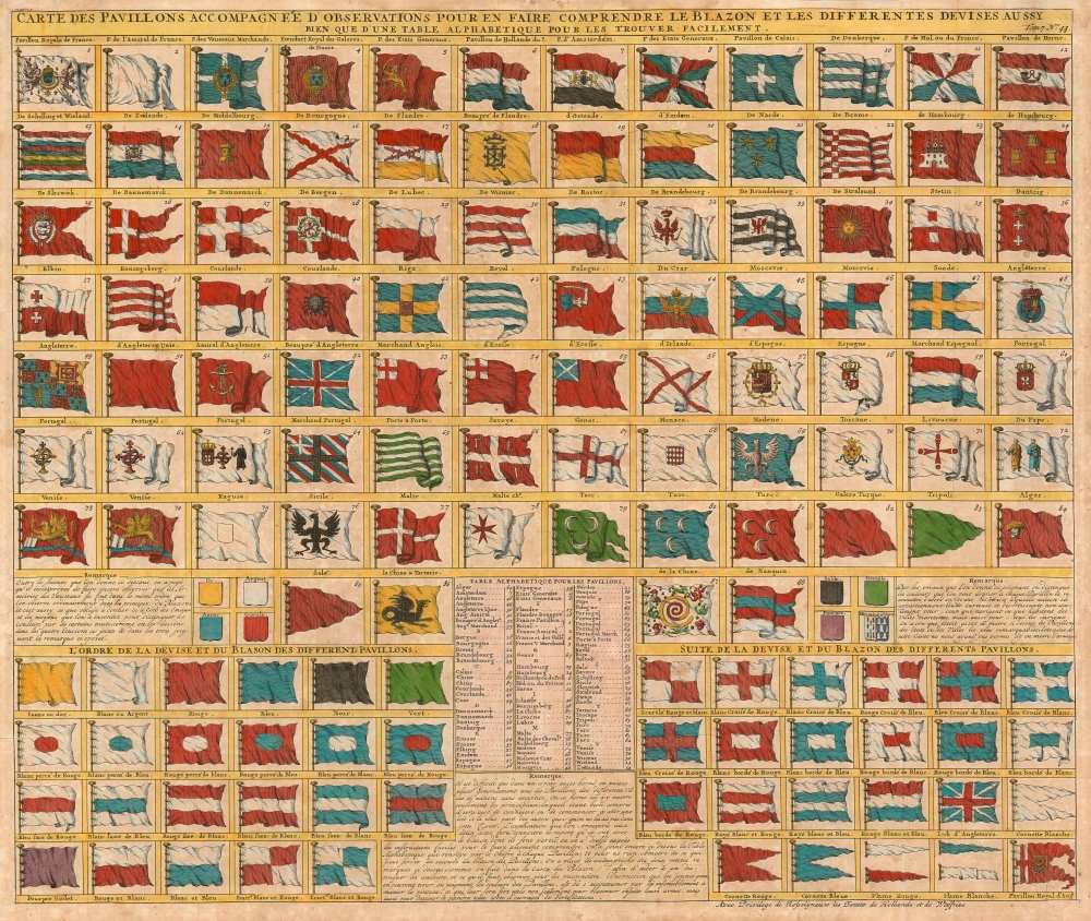
Carte des Pavillons Accompagneé D' Observatioons Pour En Faire Comprendre le Blazon et les Differentes Devises Aussy bien que d'une Table Alphabetique Pour les Trouver Facilement.
1720 (undated) 19.25 x 23 in (48.895 x 58.42 cm)
1720 (undated) 19.25 x 23 in (48.895 x 58.42 cm)
Description
This 1720 Chatelain flag chart illustrates the world's flags during The War of the Spanish Succession (1701 - 1714) and the Great Northern War (1700 - 1720).
In addition to the actual flags depicted on the sheet, Chatelain provides a primer for understanding a flag's heraldic terminology in general and supplies the reader with an alphabetical table to aid in the location of specific flags on the sheet.
A Closer Look
The image displays 88 beautifully engraved and colored flags, primarily of European nations. In several cases, more than one flag is illustrated. For example, the French flags include the Royal Flag, the Admiral's flag, the flag of the Merchant Marine, and the flag of the Estates General. Four Ottoman flags appear, not counting the specific flags of Algeria and Tripoli. England is represented by six flags, not counting two for Scotland and one further for Ireland. This chart features several other rarely seen flags: in the lower row, the Dragon Ensign of China stands out. It appears as a great whirlpool surrounded by eight decorations. This is most likely based upon an image of the Chinese flag appearing in Carel Allard's 1705 Dutch flag book Niewe Hollandse Scheepsbouw. In fact, it is a misinterpretation of the Qing flag, a dragon on a yellow field with eight banners. Other flags of interest include Pope's banner, a curious Portuguese flag bearing a priest, the flags of various trading companies, the Flag of the Tartars (dragon), and the arm and saber banner of Poland. Courland (Kurzeme, the western part of Latvia) sports both a national banner and a naval flag featuring a black crab on a field of red.In addition to the actual flags depicted on the sheet, Chatelain provides a primer for understanding a flag's heraldic terminology in general and supplies the reader with an alphabetical table to aid in the location of specific flags on the sheet.
Publication History and Census
This sheet was printed in the last of the seven volumes of Chatelain's Atlas Historique, a monumental work published over the course of some 15 years - the first volume was completed in 1705, the seventh in 1720. Though this sheet does not appear separately in OCLC, the atlas is well represented in institutional collections.Cartographer
Henri Abraham Chatelain (1684 - 1743) was a Huguenot pastor of Parisian origins. He lived consecutively in Paris, St. Martins, London (c. 1710), The Hague (c. 1721) and Amsterdam (c. 1728). He is best known as a Dutch cartographer and more specifically for his cartographic contribution in the seminal seven volume Atlas Historique, published in Amsterdam between 1705 and 1720. Innovative for its time, the Atlas Historique combined fine engraving and artwork with scholarly studies of geography, history, ethnology, heraldry, and cosmography. Some scholarship suggests that the Atlas Historique was not exclusively compiled by Henri Chatelain, as is commonly believed, but rather was a family enterprise involving Henri, his father Zacharie and his brother, also Zacharie. More by this mapmaker...
Source
Chatelain, H., Atlas historique, ou Nouvelle introduction à l'histoire, à la chronologie et à la géographie ancienne et moderne..., (Amsterdam: L. Honoré et Chatelain) 1720.
Condition
Very good. Marginal mend upper left. Light wear at folds and general toning.