This item has been sold, but you can get on the Waitlist to be notified if another example becomes available, or purchase a digital scan.
1868 Colton Chart of the Flags of All Nations
FlagChart-colton-1868$475.00

Title
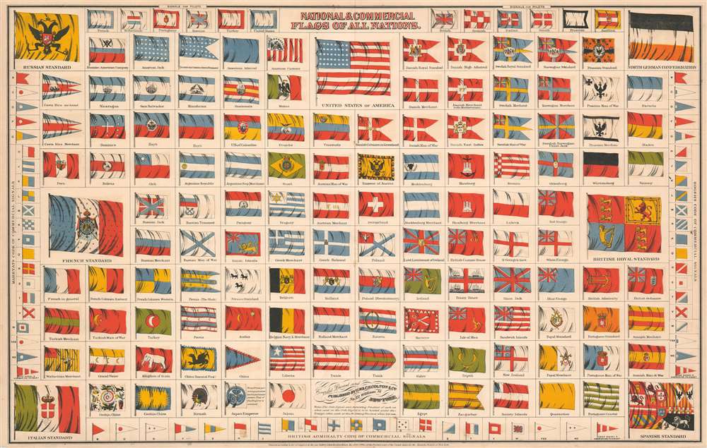
National and Commercial Flags of All Nations.
1868 (dated) 17.25 x 27.25 in (43.815 x 69.215 cm)
1868 (dated) 17.25 x 27.25 in (43.815 x 69.215 cm)
Description
This is an 1868 George Woolworth Colton and Charles B. Colton chart of the flags of the world. Over one hundred different flags are illustrated, including several ephemeral ensigns, such as those of the Russian American Company, the United States of Colombia, and the Wallachian Merchant flag. Twelve different flags designating pilot boats are illustrated along the top border, which were useful signals for mariners navigating difficult harbors.
Codes of Commercial Signals
Perhaps the most intriguing aspect of this chart is the inclusion of three different codes of commercial signals along the left, right, and bottom borders. Marrayat's Code of Commercial Signals, detailed along the left border, was first published by Frederick Marrayat in his Code of Signals of the Merchant Service in 1817. This code, which was adopted by the Merchant Service of Great Britain, employed a series of flags to allow for easy communication between British merchant ships. A rival code, identified here as Roger's Code of Commercial Signals and was also known as the 'American Code of Marine Signals', was adopted by the U.S. Navy, the Coast Survey, and the Light House Establishment of the United States, as well as by American merchant sailors. The British Admiralty Code of Commercial Signals is detailed along the bottom border, and unfortunately, we have been unable to unearth any specific details relating to this code. All three of these codes were theoretically superseded by the advent of the International Code of Signals, although adoption of this code was sporadic and took decades to implement. One addition introduced by the International Code of Signals was a bright yellow standard that signaled the vessel flying it was under quarantine, which is also included here. This likely means that the Coltons were aware of the new code but that it had not yet been universally accepted.Publication History and Census
This chart was 'compiled, printed, and published by G.W. and C.B. Colton in 1868. Examples are catalogued as being part of the institutional collections at the Library of Congress and the David Rumsey Map Collection.Cartographer
Joseph Hutchins Colton (July 5, 1800 - July 29, 1893), often publishing as J. H. Colton, was an important American map and atlas publisher active from 1833 to 1897. Colton's firm arose from humble beginnings when he moved to New York in 1831 and befriended the established engraver, Samuel Stiles. He worked under Stiles as the 'Co.' in Stiles and Co. from 1833 to 1836. Colton quickly recognized an emerging market in railroad maps and immigrant guides. Not a cartographer or engraver himself, Colton's initial business practice mostly involved purchasing the copyrights of other cartographers, most notably David H. Burr, and reissuing them with updated engraving and border work. His first maps, produced in 1833, were based on earlier Burr maps and depicted New York State and New York City. Between 1833 and 1855, Colton proceeded to publish a large corpus of guidebooks and railroad maps, which proved popular. In the early 1850s, Colton brought his two sons, George Woolworth Colton (1827 - 1901) and Charles B. Colton (1832 - 1916), into the map business. G. W. Colton, trained as a cartographer and engraver, was particularly inspired by the idea of creating a large and detailed world atlas to compete with established European firms for the U.S. market. In 1855, G.W. Colton issued volume one of the impressive two-volume Colton's Atlas of the World. Volume two followed a year later. Possibly because of the expense of purchasing a two-volume atlas set, the sales of the Atlas of the World did not meet Colton's expectations, and so, in 1856, the firm also issued the atlas as a single volume. The maps contained in this superb work were all original engravings, and most bear an 1855 copyright. All of the maps were surrounded by an attractive spiral motif border that would become a hallmark of Colton's atlas maps well into the 1880s. In 1857, the slightly smaller Colton's General Atlas replaced the Atlas of the World. Most early editions of the General Atlas published from 1857 to 1859 do not have the trademark Colton spiral border, which was removed to allow the maps to fit into a smaller format volume. Their customers must have missed the border because it was reinstated in 1860 and remained in all subsequent publications of the atlas. There were also darker times ahead; in 1858, Colton was commissioned at a sum of 25,000 USD by the government of Bolivia to produce and deliver 10,000 copies of a large format map of that country. Although Colton completed the contract in good faith, delivering the maps at his own expense, he was never paid by Bolivia, which was at the time in the midst of a series of national revolutions. Colton would spend the remainder of his days fighting with the Bolivian and Peruvian governments over this payment, and in the end, after a congressional intervention, he received as much as 100,000 USD in compensation. Nonetheless, at the time, it was a disastrous blow. J. H. Colton and Company is listed as one of New York's failed companies in the postal record of 1859. This led Colton into the arms of Alvin Jewett Johnson and Ross C. Browning. The 1859 edition of Colton's General Atlas lists Johnson and Browning as the 'Successor's to J. H. Colton' suggesting an outright buyout, but given that both companies continued to publish separately, the reality is likely more complex. Whatever the case may have been, this arrangement gave Johnson and Browning access to many of Colton's map plates and gave birth to Johnson's New Illustrated (Steel Plate) Family Atlas. The Johnson's Atlas was published parallel to Colton's atlases well into the 1880s. The Colton firm itself subsequently published several other atlases including an Atlas of America, the Illustrated Cabinet Atlas, the Octavo Atlas of the Union, and Colton's Quarto Atlas of the World. They also published a large corpus of wall maps, pocket maps, and guides. The last known publications of the Colton firm date to 1897 and include a map and a view, both issued in association with the Merchant's Association of New York. Alice M. Colton married August R. Ohman (May 3, 1859 - April 22, 1934) on January 5, 1897. In 1898, Ohman joined the Colton firm, which continued to publish as Colton, Ohman & Co. until 1901. More by this mapmaker...
Condition
Very good. Even overall toning. Light wear along original centerfold. Exhibits light soiling. Closed margin tears professionally repaired on verso. Blank on verso.
References
Rumsey 0152.006.