This item has been sold, but you can get on the Waitlist to be notified if another example becomes available, or purchase a digital scan.
1711 Petrus Schenk Flag Chart (including early Flag of New England)
FlagChart-schenk-1711$1,450.00

Title
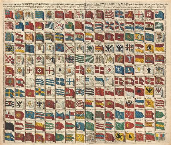
Schouw-park aller Scheeps-Vlaggen des geheelen Water-Waerelds . . . / Tableau des Pavillons de Mer, qui se trouvent dans tous les lieux du Monde Aquatique Augmente de 50 aui n ont jamais ete mis en lumiere . . . 1711.
1711 (dated) 20 x 23 in (50.8 x 58.42 cm)
1711 (dated) 20 x 23 in (50.8 x 58.42 cm)
Description
A rare and exceptional 1711 flag chart by Petrus Schenk illustrating the ephemeral Globe Flag of New England, as well as the flags of various trading companies, including the Dutch East India Company (VOC, Verenigde Oostindische Compagnie) and the Dutch West India Company (WIC, Geoctroyeerde Westindische Compagnie).
This chart's most historically significant element is its illustration of the ephemeral New England Globe Flag, one of the earliest New England flags and in fact one of the earliest examples of a fully American flag. This flag and its appearance on this chart is described in the Rhode Island Historical Society Collections (January 1930, Volume XXIII, page 97):
This chart features several other rarely seen flags, including the flags of the VOC and WIC, important Dutch merchant trading companies located in the upper right quadrant. Although private commercial ventures, these companies had the military and financial power of independent nations and were often treated as such.
At bottom center the flag of Empire of China (Sina) stands out. It appears as a great whirlpool surrounded by eight decorations. This is most likely based upon an image of the Chinese flag appearing in Carel Allard's, 1705 Dutch flag book, Niewe Hollandse Scheeps Bouw. In fact, it is a misinterpretation of the Qing flag, a dragon on a yellow field with eight banners. However, Schenk, likely having never seen a Chinese flag, interpreted the dragon to the best of his ability.
Also included in this chart are the following interesting flags, Spanish Galicia, Barcelona, Galicia, Biscay, Majorca, Jerusalem, Ragusa (Sicily), Riga, Constantinople, Slavonia, Persia, Nanking (Nanjing), the King of the Tartars, Tartary, and the Empire of Japan.
This map was issued in Amsterdam by Petrus Schenk in 1711, the last year of his life.
This chart's most historically significant element is its illustration of the ephemeral New England Globe Flag, one of the earliest New England flags and in fact one of the earliest examples of a fully American flag. This flag and its appearance on this chart is described in the Rhode Island Historical Society Collections (January 1930, Volume XXIII, page 97):
The first dated reference to the globe flag seems to be in the 'Schouw-Park aller Scheeps-Vlaggen' or 'Tableau des Pavilions de Mer,' which was published by Pieter Schenk at Amsterdam in 1711. The New England flag is shown hand colored and with the colors also shown by tincture lines, as a blue flag, having a white canton with a red cross and with a globe on a standard in the first quarter of the canton. The globe is outlined in black, but no color is specified. No reference to this globe flag has been found in any contemporary English or American writings…New England had several early flags. The earliest, was the flag of the Massachusetts Bay Colony, a white canton on a red field, of which there are no surviving illustrations. The flag changed c. 1686 to include St. George's Cross and a pine or oak tree in the upper left quadrant. The oak tree was reinterpreted as a globe and the field changed to blue around 1711, when this chart was issued, making one of the earliest, if not the first, printed illustration of the Globe Flag of New England.
This chart features several other rarely seen flags, including the flags of the VOC and WIC, important Dutch merchant trading companies located in the upper right quadrant. Although private commercial ventures, these companies had the military and financial power of independent nations and were often treated as such.
At bottom center the flag of Empire of China (Sina) stands out. It appears as a great whirlpool surrounded by eight decorations. This is most likely based upon an image of the Chinese flag appearing in Carel Allard's, 1705 Dutch flag book, Niewe Hollandse Scheeps Bouw. In fact, it is a misinterpretation of the Qing flag, a dragon on a yellow field with eight banners. However, Schenk, likely having never seen a Chinese flag, interpreted the dragon to the best of his ability.
Also included in this chart are the following interesting flags, Spanish Galicia, Barcelona, Galicia, Biscay, Majorca, Jerusalem, Ragusa (Sicily), Riga, Constantinople, Slavonia, Persia, Nanking (Nanjing), the King of the Tartars, Tartary, and the Empire of Japan.
This map was issued in Amsterdam by Petrus Schenk in 1711, the last year of his life.
Cartographer
Petrus Schenk (Pieter Schenck) the Elder (December 26, 1660 - 1711) was a Dutch engraver, globe maker, and map publisher active in Amsterdam and Leipzig in the latter half of the 17th century. Schenk, was born in Elberfield, Germany. He moved in Amsterdam in 1675, becoming the apprentice to Gerard Valk (Valck). In 1687, Schenk married Agatha Valk, Gerard Valk's sister and went into partnership with his brother-in-law under the imprint of 'Valk and Schenk'. Initially they focused on maps and atlases, acquiring the map plates of Jan Jansson and Jodocus Hondius in 1694. Later, in 1701 they moved into the former Hondius offices where they began producing globes. Valk and Schenk quickly became known for producing the best globes in the Netherlands, a business on which they held a near monopoly for nearly 50 years. Schenk's three sons, Pieter Schenk the Younger, Jan Schenk, and Leonard Schenk, all became engravers in their own right. Pieter Schenk the Younger inherited the business and ran his father's shop in Leipzig. His daughter, Maria Schenk, married Leonard Valk, the son of Gerard Valk, and continued to run the Valk and Schenk map engraving workshop in Amsterdam. More by this mapmaker...
Condition
Very good. Minor verso reinforcement along original centerfold.
References
OCLC 694019827. Rhode Island Historical Society Collections January 1930, Volume XXIII, page 97.