This item has been sold, but you can get on the Waitlist to be notified if another example becomes available, or purchase a digital scan.
1850 Andriveau-Goujon Vexillological or Flag Chart of Naval Powers
FlagMap-andriveau-1837$200.00

Title
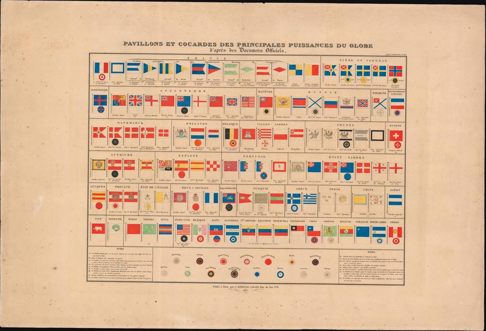
Pavillons et Cocardes des Principales Puissances du Globe.
1837 (dated) 18.75 x 23.75 in (47.625 x 60.325 cm)
1837 (dated) 18.75 x 23.75 in (47.625 x 60.325 cm)
Description
This is an 1837 flag chart produced in Paris by Andriveau-Goujon. It shows the naval, merchant, and national or royal flags of European, American, and Asian kingdoms, republics, port cities, and trading assemblies.
One benefit of the relative stability of the 19th century was increased trade, facilitated by treaties as well as the reforms undertaken under Napoleon's rule. Improvements in naval technology, the increasing naval dominance of the British Empire, the emergence of its former colony in the United States as a naval and commercial power, and early manifestations of the philosophy of free trade (as opposed to mercantilism) all aided the increase of maritime trade over this period.
A Closer Look at the Map
The table includes over one hundred maritime ensigns of various nations and kingdoms. Major European powers such as Great Britain, Russia, France, Austria, Prussia are featured prominently, but the table also includes the flags of Mediterranean states such as the Ottoman Empire and Morocco, as well as Asian powers such as China, Japan, Persia, and even Burma. Several polities have a wide array of flags depending on naval fleet, merchant fleet, constituent states, and port cities. Prominently, at top, are two flags for each of the five French coastal maritime sections (arrondissements) of Cherbourg, Brest, Lorient, Rochefort, and Toulon (each of these was designated a 'port of war'; this system of coastal administration lasted until the First World War).Stability and Trade in the 19th Century
This table is a product of the era of the post-Napoleonic 'Concert of Europe,' premised on maintaining stability in both domestic and international relations. In reality, while many nationalist and liberal movements were suppressed, they remained at the forefront of European affairs for many decades and burst forth periodically, as in 1830 and 1848.One benefit of the relative stability of the 19th century was increased trade, facilitated by treaties as well as the reforms undertaken under Napoleon's rule. Improvements in naval technology, the increasing naval dominance of the British Empire, the emergence of its former colony in the United States as a naval and commercial power, and early manifestations of the philosophy of free trade (as opposed to mercantilism) all aided the increase of maritime trade over this period.
Publication History and Census
This chart was published in 1837 by the Parisian publishing house Andriveau-Goujon as part of their Atlas classique et universel de géographie ancienne et modern. The atlas is held by a handful of libraries in Europe and the United States, and the chart is scarce to the market.Cartographer
Eugène Andriveau-Goujon (1832 - 1897) was a map publisher and cartographer active in 19th century Paris. The firm was created in 1825 when Eugène Andriveau married the daughter of map publisher Jean Goujon - thus creating Andriveau-Goujon. Maps by Andriveau-Goujon are often confusing to identify as they can be alternately singed J. Goujon, J. Andriveau, J. Andriveau-Goujon, E. Andriveau-Goujon, or simply Andriveau-Goujon. This refers to the multiple generations of the Andriveau-Goujon dynasty and the tendency to republish older material without updating the imprint. The earliest maps to have the Andriveau-Goujon imprint were released by Jean Andriveau-Goujon. He passed the business to his son Gilbert-Gabriel Andriveau-Goujon, who in 1858 passed to his son, Eugène Andriveau-Goujon, under whose management the firm was most prolific. Andriveau-Goujon published numerous fine pocket maps and atlases throughout the 19th century and often worked with other prominent French cartographers of the time such as Brue and Levasseur. The firm's stock was acquired by M. Barrère in 1892. More by this mapmaker...
Condition
Good. Foxing in margins. Some wear along edges.
References
Rumsey 2486.044. OCLC 717893555.