This item has been sold, but you can get on the Waitlist to be notified if another example becomes available.
1960 National Park Service Pictorial Map of Everglades National Park, Florida
FlamingoEverglades-smiley-1960$125.00

Title
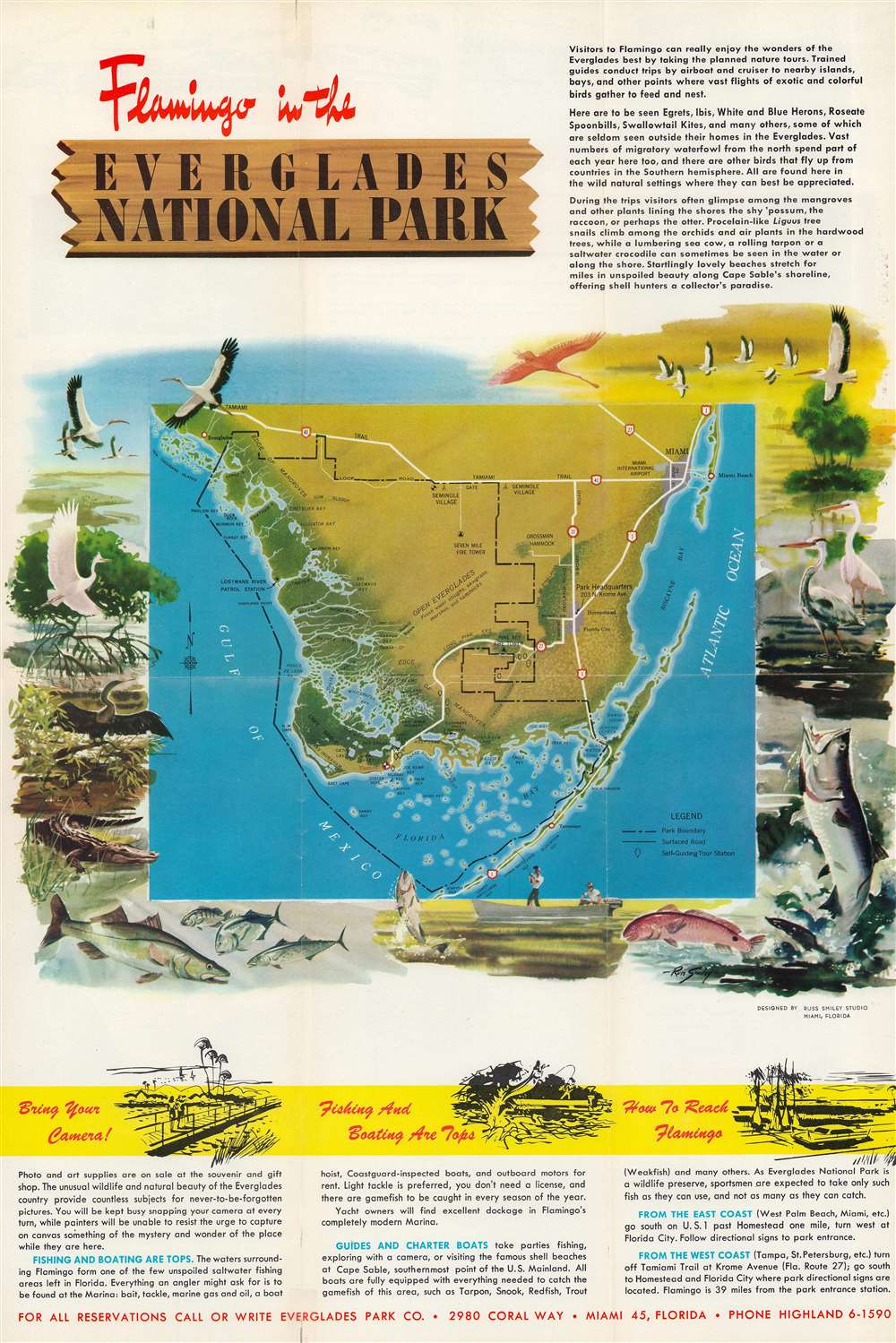
Flamingo in the Everglades National Park.
1960 (undated) 17.5 x 12 in (44.45 x 30.48 cm)
1960 (undated) 17.5 x 12 in (44.45 x 30.48 cm)
Description
This is a c. 1960 National Park Service pictorial map of Everglades National Park featuring illustrations by Florida wildlife artist Russ Smiley. Depicting southern Florida from the Tamiami Trail south to Jewfish Key, a black dashed line highlights the boundary of Everglades National Park. Highway 1, 41, and 27, are illustrated and landmarks within the park, such are Seven Mile Fire Tower and Pine Key Fire Tower, are marked. Rookeries, ponds, streams, bays, keys, and other natural sites are identified throughout. The map is surrounded by Russ Smiley's illustrations of Florida's birds, fish, and an alligator.
An Advertisement for the Park
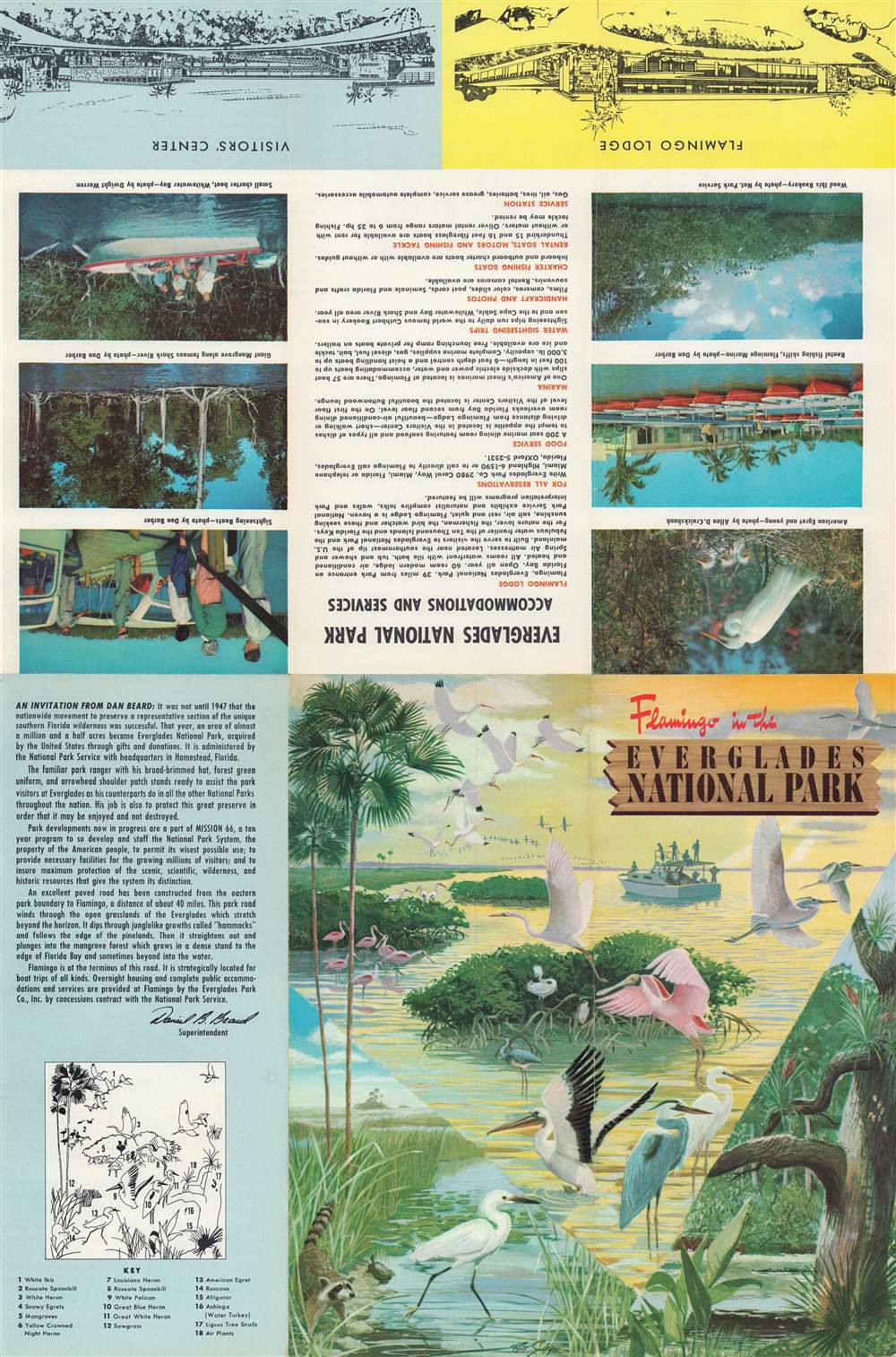
Published c. 1960, this brochure was published to promote Everglades National Park's newest accommodations and services, including the Flamingo Lodge. This lodge, which closed in the late 2000s due to hurricane damage, proved controversial. From 1956 through 1966, the National Park Service embarked on 'Mission 66', an ambitious plan to help 'modernize' the national parks and better welcome visitors. Everglades was one of the nation's newest parks, and as such very little infrastructure had been built. It is worth noting that the government's attention had been on fighting World War II and rebuilding Europe for most of the 1940s and early 1950s, which makes the lack of construction projects at Everglades more understandable. When planning the 'Mission 66' projects for Everglades, some people promoted the idea of a lodge so visitors would not have to drive back to Homestead, Florida, some forty miles distant. Others believed that allowing visitors in the park overnight would be dangerous for the ecosystem. Eventually, the forces of convenience won out, and the Flamingo Lodge was built and opened in 1960.Publication History and Census
This map was created by Russ Smiley and published by the National Park Service c. 1960. The only confirmed cataloged example is part of the Touchton Map Library at the Tampa Bay History Center.Cartographer
Russell Jenson Smiley (March 30, 1922 - December 11, 2003) was an American artist. Born in Nevada, by 1942 Smiley was living in Miami, Florida. During the 1950s, Smiley made a name for himself creating art celebrating Florida's wildlife. Many of his pieces focused on fishing. According to the biography printed on 'Russ Smiley's Fishing and Skindiving Map of South Florida New Edition, 'Russ Smiley has been drawing fish for 40 years - his art has appeared in National Geographic, Sports Afield, Fin, etc. He illustrated the 'Guide to the Everglades National Parkand Florida Keys'. His original paintings of fish, wildlife and landscapes hang in many private collections. Russ's illustrations and pictorial maps and limited edition prints shave received National recognition.' More by this mapmaker...
Condition
Very good. Light wear along original fold lines. Text, printed images, and illustration by Russ Smiley on verso.
References
Tampa Bay History Center, Touchton Map Library, 2018.055.012.