This item has been sold, but you can get on the Waitlist to be notified if another example becomes available, or purchase a digital scan.
1764 Bellin Map of the Mississippi Delta, Lake Pontchartrain and New Orleans
FleuveSaintLouis-bellin-1764$150.00

Title
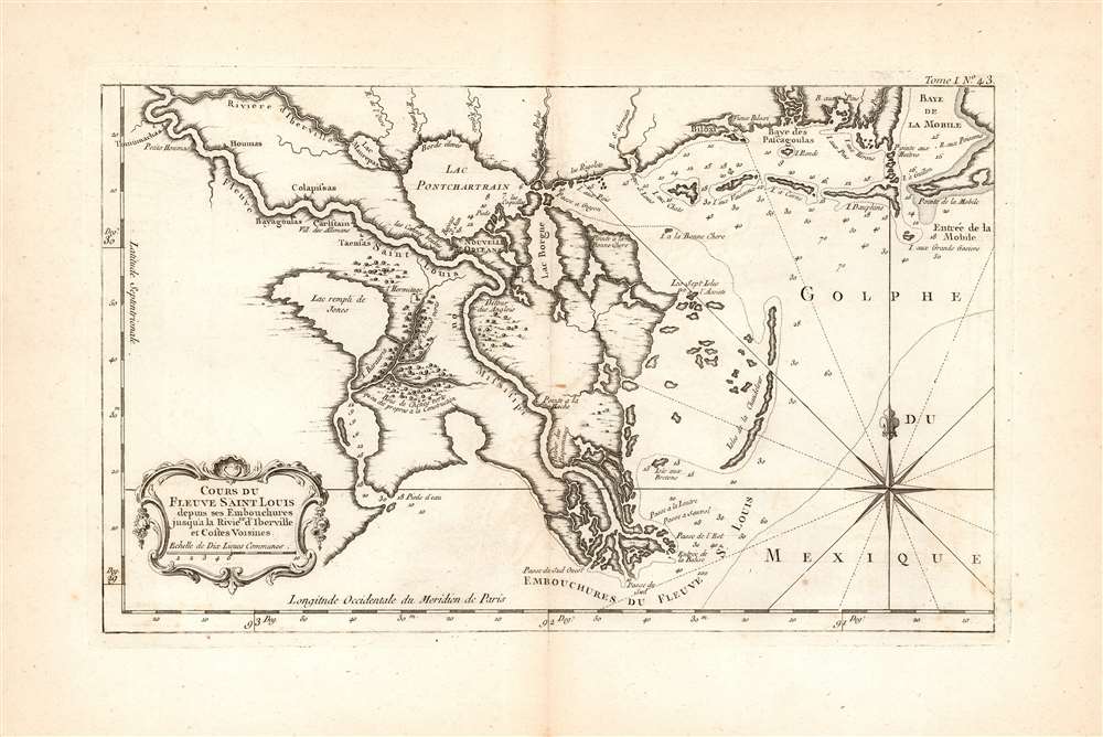
Cours du fleuve Saint Louis depuis ses embouchures jusqu'à la rivière d'Iberville et costes voisines.
1764 (undated) 8.5 x 14 in (21.59 x 35.56 cm) 1 : 830000
1764 (undated) 8.5 x 14 in (21.59 x 35.56 cm) 1 : 830000
Description
This is a 1764 Jacques-Nicolas Bellin map of the Gulf Coast of Louisiana, Mississippi, and part of Alabama. The map's western extent includes the juncture of the Mississippi and the 'Rivier d'Iberville' (actually the Bayou Manchac) and an unnamed lake (possibly Lake Salvador.) The northern reaches of the map include the Rivier d'Iberville, Lake Maurepas, Lake Pontchartrain, and the Gulf coast as far as Mobile Bay. The central focus of the map is the lower Mississippi River and its complicated delta. The city of New Orleans is prominently noted. The region's labyrinthine coastline is heavily notated with depth soundings and the names of many smaller islands; key features are noted as well, such as the large shallow lake which is said to have been 'filled by Jones,' and a 'green oak wood said to be suitable for construction.' Upriver from New Orleans appears a settlement called Carlstain Vill. des Allemans: this was a remnant of the disastrous German settlement of the Mississippi under the aegis of John Law's infamous Company of the West.
The Mississippi is referred to here as the River of Saint Louis, a terminology introduced in French maps in the early 18th century - possibly initially by Guillaume De l'Isle in his 1718 Carte de la Louisiane although the name does not appear in that mapmaker's 1703 Carte du Mexique et de la Floride.
The Mississippi is referred to here as the River of Saint Louis, a terminology introduced in French maps in the early 18th century - possibly initially by Guillaume De l'Isle in his 1718 Carte de la Louisiane although the name does not appear in that mapmaker's 1703 Carte du Mexique et de la Floride.
Publication History and Census
This map was created by Jaques-Nicolas Bellin and published in his Petit Atlas Maritimein 1764. The atlas is well represented in institutional collections; twelve separate copies of this map are catalogued in OCLC.Cartographer
Jacques-Nicolas Bellin (1703 - March 21, 1772) was one of the most important cartographers of the 18th century. With a career spanning some 50 years, Bellin is best understood as geographe de cabinet and transitional mapmaker spanning the gap between 18th and early-19th century cartographic styles. His long career as Hydrographer and Ingénieur Hydrographe at the French Dépôt des cartes et plans de la Marine resulted in hundreds of high quality nautical charts of practically everywhere in the world. A true child of the Enlightenment Era, Bellin's work focuses on function and accuracy tending in the process to be less decorative than the earlier 17th and 18th century cartographic work. Unlike many of his contemporaries, Bellin was always careful to cite his references and his scholarly corpus consists of over 1400 articles on geography prepared for Diderot's Encyclopedie. Bellin, despite his extraordinary success, may not have enjoyed his work, which is described as "long, unpleasant, and hard." In addition to numerous maps and charts published during his lifetime, many of Bellin's maps were updated (or not) and published posthumously. He was succeeded as Ingénieur Hydrographe by his student, also a prolific and influential cartographer, Rigobert Bonne. More by this mapmaker...
Source
Bellin, J. N., Le Petit Atlas Maritime Recueil De Cartes et Plans Des Quatre Parties Du Monde. en Cinq Volumes, (Paris) 1764.
Condition
Excellent. Visible centerfold, light marginal toning; a superb example.
References
OCLC 5402160. Phillips, L. P., A List of Geographical Atlases in the Library of Congress, #3508 map 43.