This item has been sold, but you can get on the Waitlist to be notified if another example becomes available, or purchase a digital scan.
1835 S.D.U.K. City Map or Plan of Florence (Firenze), Italy
Florence2-sduk-1835$175.00

Title
Florence Firenze.
1835 (dated) 12 x 15.25 in (30.48 x 38.735 cm) 1 : 90000
1835 (dated) 12 x 15.25 in (30.48 x 38.735 cm) 1 : 90000
Description
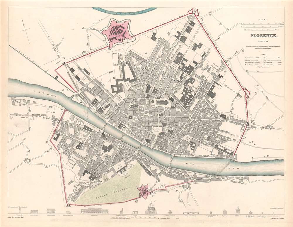
This is an 1835 Society for the Diffusion of Useful Knowledge city map or plan of Florence, Italy. The map depicts the city from the Porta al Prato to the Porta alla Croce and from the Mugnone River to the Boboli Gardens and the Porta Romana. Important historic sites, such as the Duomo, the Fortezza de Basso, labeled here as the Castello San Gio Batista, the Boboli Gardens, and the Ufizi Gallery, are labeled. Streets, squares, churches, and other sites throughout the city are also identified. Profile views of sixteen important sites around Florence, including the Duomo (cathedral), Pitti Palace, the Baptistery, and the Medici Palace adorn the bottom border.
Publication History
This map was drawn by William Barnard Clarke, engraved by E. Turrell, and published by Baldwin and Cradock for the Society for the Diffusion of Useful Knowledge in 1835.CartographerS
The "Society for the Diffusion of Useful Knowledge" (1826 - 1848) was a Whiggish organization founded in 1828 at the instigation of idealistic British lord Henry Peter Brougham. The admirable goal of the Society was to distribute useful information via a series of publications to the English working and middle classes. It promoted self-education and the egalitarian sharing of all knowledge. While closely tied to the London University and publishing houses on the order of Baldwin and Cradock, Chapman and Hall, and Charles Knight, the Society failed to achieve its many lofty goals in finally closed its doors in 1848. Most likely the failure of the Society resulted from its publications being too expensive for its intended lower to middle class markets and yet not large and fine enough to appeal to the aristocratic market. Nonetheless, it did manage to publish several extraordinary atlases of impressive detail and sophistication. Their most prominent atlas consisted of some 200 separately issued maps initially published by Baldwin and Cradock and sold by subscription from 1829 to 1844. Afterwards, the Society combined the maps into a single world atlas published under the Chapman and Hall imprint. In its day, this atlas was unprecedented in its quality, scope, and cost effectiveness. Today Society, or S.D.U.K. as it is commonly known, maps are among the most impressive examples of mid-19th century English mass market cartographic publishing available. The S.D.U.K. is especially known for its beautiful and accurately detailed city plans. More by this mapmaker...
William Barnard Clarke (1806 - 1865) was an English cartographer, architect, numismatist, literary translator, art collector, and archaeological writer. Born in Cheshunt, Hertfordshire, Clarke attended St. Paul's School in London beginning in 1817 at the age of 10. It is said that as a youth Clarke spent a substantial amount of time in Rome studying architecture and also spent time studying the ruins of Pompeii. He was also instrumental in founding the Architectural Society of London and was named President of the Society in 1831. As a cartographer, Clarke was an active member of the Society for the Diffusion of Useful Knowledge and created a Celestial Atlas for the Society as well as city plans of Dublin, Milan, Warsaw, Paris, and London among several others. Clarke married Charlotte Brooks at St. Andrew Holborn in London on July 1, 1830. Learn More...
Baldwin and Cradock (fl. c. 1810 - 1860) were London based publishers working in the early to mid 19th century. They are best known for their publication of the Society for the Diffusion of Useful Knowledge's ground breaking subscription atlas. They also published John Thomson's magnificent New General Atlas from 1814 - c. 1820. In addition to their cartographic corpus, the firm had wide ranging publishing interests in many other areas, including books, broadsides, and an investment in Blackwoods Magazine. They had their offices at 47 Paternoster Row, London, England. This firm also published under the imprint Baldwin, Cradock, and Joy and Cradock and Joy. Learn More...
Condition
Very good. Even overall toning. Blank on verso.
References
Rumsey 0890.176 (atlas edition).