This item has been sold, but you can get on the Waitlist to be notified if another example becomes available, or purchase a digital scan.
1731 Homann Heirs City Map or Plan of Florence, Italy
Florentiae-hommannheirs-1731$550.00

Title
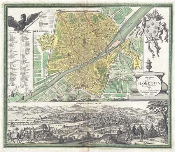
Ichnographia Urbis in Tuscia primariæ Florentiae. Scenographice.
1731 (dated) 19.5 x 23 in (49.53 x 58.42 cm) 1 : 8500
1731 (dated) 19.5 x 23 in (49.53 x 58.42 cm) 1 : 8500
Description
This is a 1731 Homann Heirs city map or plan of Florence, Italy. The map depicts the city of Florence from the Giovanni Citadel (Cittadella di Giovanni) to the Miniato Fortress (Fortezza Miniato) and from the city walls and the Porta Pinti across the Arno to the city walls and the Porta S.Pier Catto, along with some farmland just beyond the walls. With 122 different locations numerically identified within the city, a highly detailed plan of Florence is presented. The city is divided into four different districts: Maria Novteia, Sa. Giovanni, and Sa. Crocce on one side of the Arno, and S. Spirito on the other. Brunelleschi's dome, part of the Cathedral of Florence, holds a prominent place in the center of the map. As it is illustrated in profile, it is the focal point of the work. A view of Florence, looking across the city toward the Dome and the Fortezza Belvedere, dominates the bottom third of the page, allowing for a much more comprehensive understanding of the city. The Dome of the Cathedral of Florence dominates the view as well.
This map was published by Homann Heirs in 1731.
This map was published by Homann Heirs in 1731.
Cartographer
Homann Heirs (1730 - 1848) were a map publishing house based in Nuremberg, Germany, in the middle to late 18th century. After the great mapmaker Johann Baptist Homann's (1664 - 1724) death, management of the firm passed to his son Johann Christoph Homann (1703 - 1730). J. C. Homann, perhaps realizing that he would not long survive his father, stipulated in his will that the company would be inherited by his two head managers, Johann Georg Ebersberger (1695 - 1760) and Johann Michael Franz (1700 - 1761), and that it would publish only under the name 'Homann Heirs'. This designation, in various forms (Homannsche Heirs, Heritiers de Homann, Lat Homannianos Herod, Homannschen Erben, etc..) appears on maps from about 1731 onwards. The firm continued to publish maps in ever diminishing quantities until the death of its last owner, Christoph Franz Fembo (1781 - 1848). More by this mapmaker...
Condition
Very good. Verso repair of centerfold separation. Blank on verso.
References
OCLC 165847567.