This item has been sold, but you can get on the Waitlist to be notified if another example becomes available, or purchase a digital scan.
1953 British Admiralty Nautical Chart or Map of Florida
Florida-admiralty-1953$125.00

Title
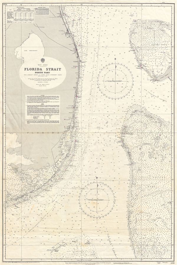
West Indies Florida Strait North Part
1953 (dated) 39.5 x 27 in (100.33 x 68.58 cm)
1953 (dated) 39.5 x 27 in (100.33 x 68.58 cm)
Description
An uncommon 1954 British Admiralty nautical chart or maritime map of South Florida, the Florida Keys, and the Great Bahama Bank, known collectively as the 'Florida Strait.' The map covers Florida from St. Lucie (Fort Capron) south to the Cay Sal Bank, including the Florida Keys west as far as Bahia Honda, and the Bahama Bank from Grand Bahama and the Little Bahama Bank to the Santaren Channel. The chart offers a wealth of practical information for the mariner and countless depth soundings in fathoms. Biscayne Bay and Miami are noted. The Admiralty originally released this chart in 1877, the present example represented updates through 1954. Represented Admiralty chart no 659.
Cartographer
The British Admiralty Office (1795 - Present) or the United Kingdom Hydrographic Office refers to the Branch of the English government that is responsible for the command of the British Navy. In 1795 King George III created the United Kingdom Hydrographic Office, known in short as the U.K.H.O., to provide top notch nautical charts to the vast Royal Navy. Prior the founding of the Admiralty the surveying and creation of nautical charts was primarily a commercial venture wherein the cartographer himself, more of than not, actually financed the printing of his own material. The great navigator Cook himself is known to have scrambled for funds to publish his own seminal charts - the most important and advanced of the period. The system of privately funded nautical mapping and publishing left vast portions of the world uncharted and many excellent charts unpublished. King George III, responding significant loss in trade revenue related to shipwrecks and delay due to poor charts, recognized the need for an institutionalized government sponsored cartographic agency - the Admiralty. The first head of the Admiralty, a position known as Hydrographer, was the important cartographer Alexander Dalrymple. Dalrymple started by organizing and cataloging obtainable charts before initiating the laborious process of updating them and filling in the blanks. The first official Admiralty Chart appeared in 1800 and detailed Quiberon Bay in Brittany. By 1808 the position of Hydrographer fell to Captain Thomas Hurd. Hurd advocated the sale of Admiralty charts to the general public and, by the time he retired in 1829, had issued and published some 736 charts. Stewardship of the organization then passed to Rear Admiral Sir Francis Beaufort. It was under Beaufort's administration that the Admiralty truly developed as a "chart making" as opposed to a "chart cataloging" institution. Beaufort held his post from 1829 to 1854. In his 25 years at the Admiralty Beaufort created nearly 1500 new charts and sponsored countless surveying and scientific expeditions - including the 1831 to 1836 voyage of the H.M.S. Beagle. By 1855 the Admiralty's chart catalog listed some 1,981 charts. More by this mapmaker...
Condition
Good. Some creasing along original centerfold. A working nautical chart, this map exhibits some erased pencil marking associated with navigational use.