This item has been sold, but you can get on the Waitlist to be notified if another example becomes available, or purchase a digital scan.
1846 Bradford Map of Florida
Florida-bradford-1846$237.50

Title
Florida.
1846 (dated) 15 x 13.5 in (38.1 x 34.29 cm) 1 : 2217600
1846 (dated) 15 x 13.5 in (38.1 x 34.29 cm) 1 : 2217600
Description
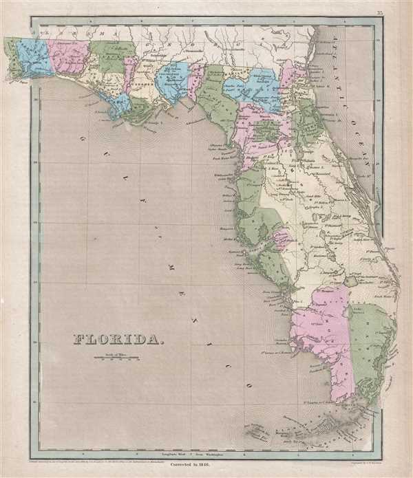
This is an 1846 Thomas Bradford map of Florida. The map depicts the state from Georgia and Alabama to the Florida Keys and from the Perdido River to Jupiter Island and the area that is occupied by Palm Beach today. Florida is divided into counties and colored accordingly, with Mosquito County making up most of Central and South-Central Florida. The most intriguing aspects of this map are two parcels of land that are colored like counties but are, in fact, private land grants.
These two grants, one labeled Arredondo's Grant, and the other Miranda's Grant, are holdovers from Spanish rule in Florida. Beginning in the 1790s, the Spanish crown offered land grants to people courageous enough to emigrate to Florida or for meritorious service to the crown. Arredondo's grant, named after Fernando de la Maza Arredondo, is located to the west of St. Augustine in Alachua county. It was granted to Arredondo in 1817 by Alexander Ramirez of Havana. Miranda's Grant, citing Pedro Miranda, a Spanish sailor, is in the vicinity of modern day Tampa. After Florida became a possession of the United States in 1821, the U.S. government declared that it would honor the land grants, as long as the owner could prove the legitimacy of the grant. Both Pedro Mirandaand Fernando de la Maza Arredondo took their case to the United States Supreme Court, where their rights to the land were affirmed, although it appears that eventually the grants were erased.
Numerous cities, towns, and villages are labeled throughout the map, including Tallahassee, Pensacola, and St. Augustine. Several forts are labeled, including Fort Lauderdale, Fort Jupiter, and Fort Pierce. Lakes, such as Lake Okeechobee and Kissimmee Lake are also illustrated, along with numerous rivers. The Everglades are also labeled.
This map was engraved by George Boynton and published by Thomas Bradford in 1846.
CartographerS
Thomas Gamaliel Bradford (1802 - 1887) was born in Boston, Massachusetts, where he worked as an assistant editor for the Encyclopedia Americana. Bradford's first major cartographic work was his revision and subsequent republishing of an important French geography by Adrian Balbi, Abrege de Geographie published in America as Atlas Designed to Illustrate the Abridgment of Universal Geography, Modern and Ancient. Afterwards Bradford revised and expanded this work into his own important contributions to American cartography, the 1838 An Illustrated Atlas Geographical, Statistical and Historical of the United States and Adjacent Countries. Bradford's cartographic work is significant as among the first to record Texas as an independent nation. In his long career as a map publisher Bradford worked with William Davis Ticknor of Boston, Freeman Hunt of New York, Charles De Silver of Philadelphia, John Hinton, George Washington Boynton, and others. We have been able to discover little of Bradford's personal life. More by this mapmaker...
George Washington Boynton (fl. c. 1830 - 1850) was a Boston based cartographer and map engraver active in the first half of the 19th century. Boynton engraved and compiled maps for numerous publishers including Thomas Bradford, Nathaniel Dearborn, Daniel Adams, and S. G. Goodrich. His most significant work is most likely his engraving of various maps for Bradford's Illustrated Atlas, Geographical, Statistical, and Historical, of the United States and the Adjacent Countries and Universal Illustrated Atlas. He also engraved for the Boston Almanac. In 1835, Boynton is listed as an employee of the Boston Bewick Company, an engraving, stereotype, and printing concern based at no. 47 Court Street, Boston. Little else is known of his life. Learn More...
Source
Bradford, T. G. and Goodrich, S. G., A Universal Illustrated Atlas, exhibiting a Geographical, Statistical, and Historical view of the World, (Boston: Charles D. Strong) 1846.
The Universal Illustrated Atlas is one of the great American atlases of the first half of the 19th century. The atlas was first published in 1838 under the imprint of Charles D. Strong. It replaced and superseded Bradford's earlier smaller format Illustrated Atlas, Geographical, Statistical, and Historical, of the United States and the Adjacent Countries. Numerous reissues of the Universal Illustrated Atlas followed until about 1848. Although there are minor variations between the editions, most contain about 50 maps, the majority of which focus on the United States. Bradford's atlases are significant for recording North America during the Republic of Texas Era. In later editions, particularly the 1846 edition, Bradford illustrates the boom in railroad construction, possibly with the idea that his maps would aid travelers in planning journeys by rail. It was compiled by Thomas Gamaliel Bradford and Samuel Griswold Goodrich with most of the plates engraved by George Washington Boynton (fl. c. 1830 - 1850). Other contributors include Thomas Gordon (1778 - 1848), Fielding Lucas Jr. (1781 - 1854), Samuel Edward Stiles (1844 - 1901), Sherman and Smith (fl. c. 1829 - 1855), and Horace Thayer (1811 - c. 1874).
Condition
Very good. Even overall toning. Blank on verso.
References
Rumsey 0089.031 (1838 edition).