This item has been sold, but you can get on the Waitlist to be notified if another example becomes available, or purchase a digital scan.
1869 Colton / Dewey Map of Florida
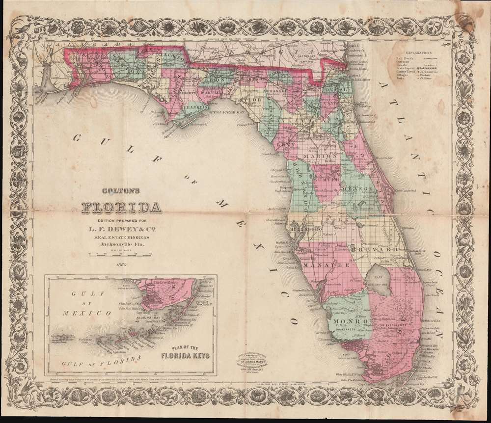
Florida-coltondewey-1869$250.00

Title
Colton's Florida edition prepared for L. F. Dewey and Co. Real Estate Brokers Jacksonville, Fla.
1869 (dated) 13.75 x 16 in (34.925 x 40.64 cm) 1 : 2534400
1869 (dated) 13.75 x 16 in (34.925 x 40.64 cm) 1 : 2534400
Description
A most unusual variant on G.W. and C. B. Colton's 1869 separate issue map of Florida. While geographically the map is little changed from Colton's atlas map of 1855, this map is unique in that it was issued to promote the Jacksonville real estate business of Lewis Fowler Dewey.
Lewis Fowler Dewey (March 23, 1835 - November 5, 1868) was an American businessman and real-estate developer active in Jacksonville, Florida. He was born in Loweville, New York. He matriculated at Wesleyan College in 1858. Before his education could be completed, he enlisted the Union Army to fight the American Civil War (1861 - 1865), serving as a commissioned First Lieutenant with the E Company 7th Calvary. Dewey survived the war and relocated to Jacksonville, Florida - likely for the weather -, establishing a real estate and law practice there. He contracted a chronic illness during the war and despite the Florida climate, succumbed in 1868, at just 33.
The Colton Map
Like most of Colton's state maps, this map was derived from an earlier wall map of North America produced by Colton and D. Griffing Johnson. The map covers the entire state of Florida and shows parts of adjacent Georgia and Alabama. An inset in the lower left quadrant details the Florida Keys. In this particular case, Colton has augmented his map with the plat work done by the Florida branch of the U.S. Land Survey.Dewey
Lewis Fowler Dewey was a Florida evangelist. He created a publishing arm of his Jacksonville Real Estate firm to promote emigration to Florida, issuing maps, books, guides, and more. His publications included such works as Florida, its climate, soil … and inducements which it offers to immigrants.Lewis Fowler Dewey (March 23, 1835 - November 5, 1868) was an American businessman and real-estate developer active in Jacksonville, Florida. He was born in Loweville, New York. He matriculated at Wesleyan College in 1858. Before his education could be completed, he enlisted the Union Army to fight the American Civil War (1861 - 1865), serving as a commissioned First Lieutenant with the E Company 7th Calvary. Dewey survived the war and relocated to Jacksonville, Florida - likely for the weather -, establishing a real estate and law practice there. He contracted a chronic illness during the war and despite the Florida climate, succumbed in 1868, at just 33.
Publication History and Census
This map was first published in 1868 for Lewis Fowler Dewey. The present example is a second edition, published in 1869 - the year after Dewey died. There appear to be only two states. The base map, by Colton, was engraved and copyrighted in 1855. This variant is rare on the market. We note an example at the Florida State Library and perhaps 11 other institutions.Cartographer
Joseph Hutchins Colton (July 5, 1800 - July 29, 1893), often publishing as J. H. Colton, was an important American map and atlas publisher active from 1833 to 1897. Colton's firm arose from humble beginnings when he moved to New York in 1831 and befriended the established engraver, Samuel Stiles. He worked under Stiles as the 'Co.' in Stiles and Co. from 1833 to 1836. Colton quickly recognized an emerging market in railroad maps and immigrant guides. Not a cartographer or engraver himself, Colton's initial business practice mostly involved purchasing the copyrights of other cartographers, most notably David H. Burr, and reissuing them with updated engraving and border work. His first maps, produced in 1833, were based on earlier Burr maps and depicted New York State and New York City. Between 1833 and 1855, Colton proceeded to publish a large corpus of guidebooks and railroad maps, which proved popular. In the early 1850s, Colton brought his two sons, George Woolworth Colton (1827 - 1901) and Charles B. Colton (1832 - 1916), into the map business. G. W. Colton, trained as a cartographer and engraver, was particularly inspired by the idea of creating a large and detailed world atlas to compete with established European firms for the U.S. market. In 1855, G.W. Colton issued volume one of the impressive two-volume Colton's Atlas of the World. Volume two followed a year later. Possibly because of the expense of purchasing a two-volume atlas set, the sales of the Atlas of the World did not meet Colton's expectations, and so, in 1856, the firm also issued the atlas as a single volume. The maps contained in this superb work were all original engravings, and most bear an 1855 copyright. All of the maps were surrounded by an attractive spiral motif border that would become a hallmark of Colton's atlas maps well into the 1880s. In 1857, the slightly smaller Colton's General Atlas replaced the Atlas of the World. Most early editions of the General Atlas published from 1857 to 1859 do not have the trademark Colton spiral border, which was removed to allow the maps to fit into a smaller format volume. Their customers must have missed the border because it was reinstated in 1860 and remained in all subsequent publications of the atlas. There were also darker times ahead; in 1858, Colton was commissioned at a sum of 25,000 USD by the government of Bolivia to produce and deliver 10,000 copies of a large format map of that country. Although Colton completed the contract in good faith, delivering the maps at his own expense, he was never paid by Bolivia, which was at the time in the midst of a series of national revolutions. Colton would spend the remainder of his days fighting with the Bolivian and Peruvian governments over this payment, and in the end, after a congressional intervention, he received as much as 100,000 USD in compensation. Nonetheless, at the time, it was a disastrous blow. J. H. Colton and Company is listed as one of New York's failed companies in the postal record of 1859. This led Colton into the arms of Alvin Jewett Johnson and Ross C. Browning. The 1859 edition of Colton's General Atlas lists Johnson and Browning as the 'Successor's to J. H. Colton' suggesting an outright buyout, but given that both companies continued to publish separately, the reality is likely more complex. Whatever the case may have been, this arrangement gave Johnson and Browning access to many of Colton's map plates and gave birth to Johnson's New Illustrated (Steel Plate) Family Atlas. The Johnson's Atlas was published parallel to Colton's atlases well into the 1880s. The Colton firm itself subsequently published several other atlases including an Atlas of America, the Illustrated Cabinet Atlas, the Octavo Atlas of the Union, and Colton's Quarto Atlas of the World. They also published a large corpus of wall maps, pocket maps, and guides. The last known publications of the Colton firm date to 1897 and include a map and a view, both issued in association with the Merchant's Association of New York. Alice M. Colton married August R. Ohman (May 3, 1859 - April 22, 1934) on January 5, 1897. In 1898, Ohman joined the Colton firm, which continued to publish as Colton, Ohman & Co. until 1901. More by this mapmaker...
Condition
Average. Map laid down on archival tissue for stability. Some staining and soiling. Repaired and reinforced fold splits.
References
OCLC 36334591. Florida State Library,
HISTORIC ERA 19TH CENTURY 0012.