
1945 Dolph Map of Florida Emphasizing Highways

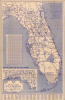

Map of Florida. / Dolph's Informative Florida Map showing New State Road Numbers.
Florida's Highway Building Boom.
- Digital Map Information
- Suitable for large format printing
- Full resolution TIFF file
- ICC color profile embedded
- Delivered instantly via download link
Florida's Highway Building Boom.
This is a large-format, c. 1945 Frank Dolph folding highway map of Florida. The map reflects Florida's sweeping 1940s expansion of its highway system, built to accommodate the state's rapidly rising population and growing tourism industry.A Closer Look
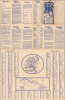
This two-tone map presents the state of Florida with county borders outlined, and cities and towns noted, along with waterways, national parks and forests, Indian reservations, canals, and other features. However, the primary focus is on highways and major roads, both state and U.S. routes, which are traced throughout with distances between cities recorded. An inset at the bottom-left displays the northwesternmost portion of the state, while an explanation of the state highway numbering system appears at the top-right, and a detailed table of distances is on the left. A population table of Florida's counties, cities, and large towns is at the bottom. A grid appears in the top and right borders, corresponding to an index of towns on the verso, which also includes a highway map of the American South and a map of Cuba, along with promotional text for Florida.Interestingly, the first item noted in the state's promotional text mentions the state not having a poll tax, which was a common Jim Crow method for Southern states to disenfranchise Black voters. In fact, Florida was arguably the first state to implement a poll tax in the 1880s, even writing it into the state constitution, but it was also among the first to repeal poll taxes. No doubt, the desire to attract migrants and visitors from Northern states was part of the motivation, which Dolph would likely have been aware of, as he had been based in the New York City area for most of his career up to this point.
Connecting the Sunshine State
This map was produced during the wartime/postwar population boom in Florida, which prompted the rapid construction of highways to meet both the growing permanent resident population and rising numbers of tourists and seasonal residents. The rudiments of this highway system had been constructed during and after the Florida Land Boom of the early 20th century. Though the real estate market crashed with the Great Depression (1929 - 1939), federal funding helped to expand Florida's road network, including the impressive Overseas Highway through the Florida Keys, completed in 1938.Publication History and Census
This map was prepared and published by Frank B. Dolph. It is undated but uses population statistics from the 1945 census, so it likely dates to just after that. The map is noted among the holdings of the University of Wisconsin - Milwaukee, the University of South Florida, and Yale University in the OCLC and is also held by the Tampa Bay History Center's Touchton Map Library.Cartographer
Frank B. Dolph (October 3, 1897 - November 26, 1975) was an American businessman and map publisher. Born in Great Neck, Long Island, New York, Dolph served as a Navy storekeeper during World War I. He began selling maps in 1919 after returning from England, likely for the George F. Cram Company, where he ultimately became an administrative aide. He also worked for the Rand McNally Company for some time before he founded his own map publishing firm, Dolph and Stewart, with his friend, sometime in the 1920s. Dolph and Stewart made maps throughout the 1920s and 1930s until they sold the firm in 1945 when Dolph decided to return to Florida. Dolph opened a new map publishing business, the Frank B. Dolph Map Co. in Ft. Lauderdale and published city plans of cities throughout the United States. Many of his maps were distributed by Chambers of Commerce or sold at newsstands. Real estate developers greatly appreciated his maps, those published by both the Dolph and Stewart Company and the Frank B. Dolph Company. Dolph retired as president of his firm around 1965, when he handed the business off to his son, Frank B. Dolph, Jr. Dolph worked with cartographer Theodore M. Politano for decades while operating the Frank B. Dolph Map Company. Further Details...
Condition
Average. Wear along original fold lines. Verso repairs to fold separations. Loss at fold intersections. Area of infill along bottom edge. Text on verso. Trimmed with slight loss to verso text but no loss to map or text on recto.
References
Touchton Map Library Accession Number L2018.087.050. OCLC 1132234787.