This item has been sold, but you can get on the Waitlist to be notified if another example becomes available, or purchase a digital scan.
1867 First Edition Drew Map of Florida - Deposit 10K Due
Florida-drew-1867$2,250.00


Title
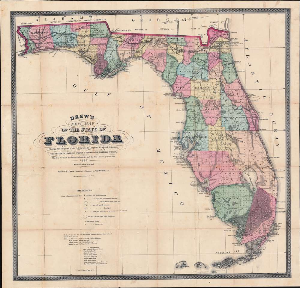
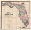
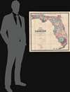
Drew's New Map of the State of Florida Showing the Progress of the U.S. Surveys, the Completed and Projected Railroads, the Different Railroad Stations and Growing Railroad Towns, the New Towns on the Rivers and Interior, and the New Counties up to the Year 1867.
1867 (dated) 25.75 x 26.75 in (65.405 x 67.945 cm) 1 : 1140480
1867 (dated) 25.75 x 26.75 in (65.405 x 67.945 cm) 1 : 1140480
Description
The holy grail of 19th century Florida cartography, this is the exceedingly rare 1867 first edition of Columbus Drew's large-scale pocket map of Florida. Printed in Jacksonville, Drew's is the first map of Florida actually printed in Florida. Moreover, this is the first large format map of Florida published after the American Civil War (1861 - 1865) and captures the state at the beginning of Reconstruction (1865 - 1877).
A number of minor roads are noted throughout the state. One major road runs down the center of the state, from Waldo to Ocala and then on to Tampa, then extending from Tampa to Charlotte Harbor.
Railroads and Roads
The map captures the infancy of the Florida railroad network which, by the end of the century, would extend throughout the state. The 'Pensacola and Georgia Railroad' and the 'Florida and Atlantic Railroad' are shown, along with a projected line for an unnamed line from Pensacola to Quincy. Further south, a line also extends to Levy County.A number of minor roads are noted throughout the state. One major road runs down the center of the state, from Waldo to Ocala and then on to Tampa, then extending from Tampa to Charlotte Harbor.
Sources
Cartographically Drew based this map on government land office surveys and military surveys dating to the Second (1835 - 1842) and Third Seminole Wars (1855 - 1858). A note on the lower left promotes land for sale by the Federal Government, Florida State, and various Railroad Companies, and offers addresses for registry offices corresponding to each. It further notes nine major freshwater springs scattered throughout the state.A Bit of Manuscript
The town of New Smyrna has been added in manuscript. New Smyrna can trace its roots to 1768, when Scottish physician Dr. Andrew Turnbull founded a British colony there. By the end of the Civil War, it was practically abandoned. In 1887, New Smyrna was formally incorporated with a population of just 150. The addition of New Smyrna to this map in manuscript thus likely dates to the late 19th century.Publication History and Census
This map was prepared and printed by Julius Bien for Columbus Drew of Jacksonville, Florida, here in its first edition, 1867. The map was updated and reissued at least thrice in the latter 19th century, in 1870 by Columbus Drew and by his son Horace Drew in 1874 and 1884. We are aware of only a single instance of this map in its first edition state appearing on the market in the last 30 years.CartographerS
Columbus Drew (January 6, 1820 - July 8, 1891) was a Florida lawyer, politician, writer, bookseller, publisher, and printer active in the mid to late 19th century. Drew was born in Virginia and grew up in Washington D.C., earning a law degree. As a young man he worked with Gales and Seaton of the National Intelligencer. By 1847 he was working as an editor of the Whig-leaning American. Before the American Civil War (1861 - 1865), Drew was an ardent Whig. He was enticed to relocate to Jacksonville, Florida in 1848 to edit the Florida-Whig journal Republican. In 1855, Drew established his stationers business - one of the first in Jacksonville. Although as a Whig he opposed both slavery and the succession, when the Civil War broke out he remained loyal to his adopted state and worked for the Confederate cause. Drew moved briefly to Richmond to take a position in the Confederate Treasury Department. After the war he returned to his stationers shop in Jacksonville where he applied for and received a Federal Pardon for working with the Confederacy. In 1876, Drew was called upon to assume the post of state Comptroller. At this time he sold his stationery business to his son, Horace (January 20, 1854 - January 4, 1926), who renamed it 'H. Drew Company'. Shortly thereafter, in 1886, Horace took on his younger brother, William B. Drew, as a partner, renaming the firm 'H. Drew and Brother'. The name was again changed in 1893, when it was formally incorporated as 'H. and W. B. Drew Company'. This firm still operates as 'Wells and Drew'. Columbus Drew was a leading figure in the development of Florida during the Reconstruction Era following the Civil War. His influence impacted the development of state railways, canals, drainage projects, and other civil works. Cartographically he is best known for the publication of his 1867 New Map of the State of Florida, which, through numerous editions and revisions, chronicles the history and development of the state during a critical period. This map is now extremely scarce in any edition. Horace Drew, who continued to publish an update his father's important map. The Drew family became leading citizens in Jacksonville and today their historic Victorian home enjoys landmark status. Drew is interred at the Old Jacksonville City Cemetery. More by this mapmaker...
Julius (Julien) Bien (September 27, 1826 - December 21, 1909) was a German-Jewish lithographer and engraver based in New York City. Bien was born in Naumburg, Germany. He was educated at the Academy of Fine Arts, Cassell and at Städel's Institute, Frankfurt-am-Main. Following the suppression of the anti-autocratic German Revolutions of 1848, Bien, who participated in the pan-German movement, found himself out of favor in his home country and joined the mass German immigration to the United States. Bien can be found in New York as early as 1849. He established the New York Lithographing, Engraving & Printing Company in New York that focused on the emergent chromo-lithograph process - a method of printing color using lithographic plates. His work drew the attention of the U.S. Government Printing Office which contracted him to produce countless government maps and surveys, including the Pacific Railroad Surveys, the census, numerous coast surveys, and various maps relating to the American Civil War. Bien also issued several atlases both privately and in conjunction with a relation, Joseph Bien. At the height of his career Bien was elected president of the American Lithographers Association. After his death in 1909, Bien's firm was taken over by his son who promptly ran it into insolvency. The firm was sold to Sheldon Franklin, who, as part of the deal, retained the right to publish under the Julius Bien imprint. In addition to his work as a printer, Bien was active in the New York German Jewish community. He was director of the New York Hebrew Technical Institute, the New York Hebrew Orphan Asylum, and president of the B'nai B'rith Order. Learn More...
Condition
Very good. Some minor foxing, even overall toning, and verso repair and reinforcements to a few tears and at fold intersections.
References
OCLC 908992004. Rumsey, 5190.001 (1870 edition). Fitzgerald, 167 (1874 edition). Phillips, (maps) 285 (1874 edition). Library of Congress, Map Division, G3931.P3 1874 .D7 RR 195. Baxter, J. M., Tequesta - An Annotated Checklist of Florida Maps, p. 115. State Library and Archives of Florida, #fmc0008.