This item has been sold, but you can get on the Waitlist to be notified if another example becomes available, or purchase a digital scan.
1893 Matthews Northrup Central and Peninsular Railroad Map of Florida
Florida-matthewsnorthrup-1893$1,250.00


Title
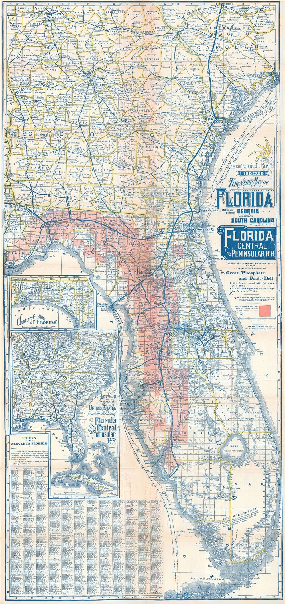
Geographically Correct Indexed Township Map of Florida Middle and Southern Georgia and Southern South Carolina showing complete system of Florida Central and Peninsular Railroad.
1893 (dated) 37 x 17.25 in (93.98 x 43.815 cm) 1 : 1126400
1893 (dated) 37 x 17.25 in (93.98 x 43.815 cm) 1 : 1126400
Description
A rare 1894 map of Florida and Georgia illustrating the Florida Central and Peninsular Railroad at its peak. The map was issued not only to highlight the FCP achievements in reaching Tampa and St. Petersburg, but also to promote the extensive discoveries of phosphates. These discoveries extend from the Apalachicola River east through the panhandle and then south to Charlotte Harbor. Two insets are situated along the left border. The top inset depicts the western portion of the Florida Panhandle and the bottom inset illustrates the railroad network in the southeastern United States. An index of locations throughout Florida occupies the lower left corner.
The Florida Central and Peninsular Railroad
The FCP was a network of railroads stretching from South Carolina to Tampa. It was Florida's first major railroad network, and the first to serve central peninsular Florida, predating Flagler's Florida East Coast Railroad by decades. It began in 1832 with the Tallahassee Rail Road, connecting Tallahassee to the Gulf of Mexico. In the 1850s the Florida, Atlantic and Gulf Central Railroad (FAGC, January 24, 1851) and the Pensacola and Georgia Railroad (PGR, January 1853) were chartered. These merged in 1869, acquiring the Tallahassee Railroad. The Pensacola and Georgia acquired the Tallahassee in 1855, and then merged with the FAGC in 1869, forming the Jacksonville, Pensacola and Mobile Railroad (JPM). The JPM acquired trackage and land rights over the Florida Central Railroad (FCR), extending their line to Cedar Key, Orlando, and ultimately Tampa. The network reached its height in 1893, when it reorganized as the Florida Central and Peninsular Railroad. From 1900, the FCP became the Seaboard Air Line Railway and much of the network remains active today.Publication History and Census
The earliest known example of this map dates to 1886, after which it was updated annually to about 1900. The present example was printed in 1894 by the Matthews Northrup Company for the Florida Central and Peninsular Railroad. We have located one example in private hands.Cartographer
Matthews-Northrup Works (fl. c. 1895 - 1930) were a Buffalo, New York based, in their own words, "writing, designing, engraving, printing, [and] binding" firm. The firm was founded by James Newson Matthews (November 21, 1828 - December 20, 1888) as the J. N. Matthews Company. William Phelps Northrup (April 2, 1850 - February 2, 1929) later joined the company as an apprentice and then partner, at which point the firm was reincorporated as the Matthews-Northrup Works. The Matthews-Northrup Works rose to prominence as publishers and printers of railroad maps, with dozens to their credit. When James died, his shares were inhered by George Edward Matthews (1855 - 1910), who ran the business until his death in 1910. Also in 1910, they famously redesigned the cover of National Geographic Magazine. Despite some six previous cover changes in just 21 years, the Matthews-Northrup layout proved so popular that it was used for nearly 50 years. The firm can also take credit for the Winchell typeface, designed in 1903 under E. E. Winchell's tenure as art director. Curiously, the partners of Matthews-Northrup maintained an unusual affectation in which only the officers of the company could wear beards or mustaches. In this same spirit, the firm also had its own private social club, the Fellowcraft Club, where the all-male employees could relax, play pool, drink and dine. Matthews-Northrup maintained offices on Washington Street, Buffalo, where they were based, as well as Madison Square, New York City, Garden Tower, Boston, and the Citizens Building in Cleveland. More by this mapmaker...
Condition
Very good. Exhibits wear along original fold lines. Exhibits areas of infill along a few original fold lines and at two fold intersections. Text on verso.