This item has been sold, but you can get on the Waitlist to be notified if another example becomes available, or purchase a digital scan.
1925 Mid-West Map Company Tourist Road Map of Florida
Florida-midwestmapco-1925$175.00

Title
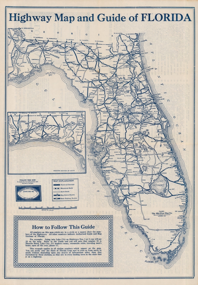
Highway Map and Guide of Florida.
1925 (undated) 19 x 13.25 in (48.26 x 33.655 cm) 1 : 1414549
1925 (undated) 19 x 13.25 in (48.26 x 33.655 cm) 1 : 1414549
Description
This is a c. 1925 Mid-West Map Company tourist road map of Florida created as part of a series of maps promoting Authorized Guide and Map Stations across the country. It was produced at the height of the Florida Land Boom, when the state's road infrastructure expanded rapidly to accommodate travel to Miami, West Palm Beach, and other nearby towns.
Flagler and other boosters of the region successfully promoted it as a paradisical escape from the grimy cities and cold weather of New England and the Mid-Atlantic. Land prices shot up at an astronomical rate and developers carved entirely new cities out of wetlands in mere months. In addition to Flagler's railway, the arrival of the highway system in the 1920s made the region more easily accessible. But the speculation around land prices in Florida had reached irrational heights, and the damage caused by two hurricanes followed by the financial crash of 1929 led to a collapse in the real estate market, ruining many investors in the process.
A Closer Look
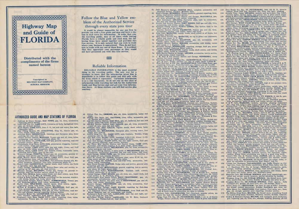
Thick dark lines highlight paved or graveled roads, including state highways, while dirt (earth) roads are also illustrated. Cities and towns are identified, while numbers indicate 'Authorized Guide and Map Stations' which are listed in a corresponding index on the verso. An inset at bottom-left is a continuation of the main map covering the Florida Panhandle.Florida Land Boom
In the second half of the 19th and throughout the early 20th century, Florida experienced a series of land booms and crashes; the most well-known of these occurred in the 1920s. The collapse of a previous land boom that established Florida as a center for the citrus industry in the 1880s - 1890s allowed for the easy acquisition of large tracts of land at cut-rate prices. Industrialist and founder of Standard Oil Henry Flagler (1830 - 1913) seized the opportunity to build his Florida East Coast Railway and extend it to the region that would develop into Miami and other communities on the state's southeastern coast.Flagler and other boosters of the region successfully promoted it as a paradisical escape from the grimy cities and cold weather of New England and the Mid-Atlantic. Land prices shot up at an astronomical rate and developers carved entirely new cities out of wetlands in mere months. In addition to Flagler's railway, the arrival of the highway system in the 1920s made the region more easily accessible. But the speculation around land prices in Florida had reached irrational heights, and the damage caused by two hurricanes followed by the financial crash of 1929 led to a collapse in the real estate market, ruining many investors in the process.
Publication History and Census
This map was created by the Mid-West Map Company c. 1925; the lack of a U.S. Route shield, instituted in 1926, precludes a later date. State Route 4 along the state's eastern coast was re-designated U.S. Route 1 in 1926, also supporting a date of 1925 or earlier. Therefore, this appears to be an early edition of the company's Florida highway map, likely the first, which was issued at least two more times in the following years with more advertising on the recto and updates to the highway numbering system as just noted (see, for example, the c. 1927 example previously sold by us). There are no other known examples of the present edition of this map in institutional collections or on the market, while later editions are held by the University of South Florida and the Touchton Map Library at the Tampa Bay History Center.Cartographer
Mid-West Map Company (c. 1925 - 1935) was an Aurora, Missouri-based company that issued early highway maps to travelers for free, covering their costs and earning a profit through sponsorship and advertisements for gas stations, motels, and other businesses along highway routes. Little is known about the company's history and its maps were undated, making an exact date range of its existence difficult to establish, but the company's efforts resulted in the first comprehensive set of highway maps for the entire country. Its model of providing free highway maps to travelers would become a standard practice for decades, especially by competing gas station chains. More by this mapmaker...
Condition
Very good. Minor wear at fold intersections. Closed tear extending one (1) inch into printed area from center top margin professionally repaired on verso.