This item has been sold, but you can get on the Waitlist to be notified if another example becomes available, or purchase a digital scan.
1881 Bureau of Immigration Map of Florida w/transport lines
Florida-randmcnally-1881$175.00

Title
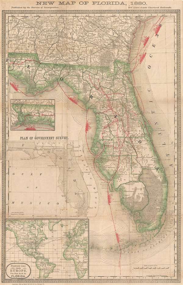
New Map of Florida, 1880.
1881 (dated) 20.25 x 13 in (51.435 x 33.02 cm) 1 : 2000000
1881 (dated) 20.25 x 13 in (51.435 x 33.02 cm) 1 : 2000000
Description
This is an unusual and rare 1881 map of Florida issued by the Bureau of Immigration and Rand McNally. The map covers all of Florida as well as the Florida Keys and adjacent parts of Georgia as far north as Savannah. Red overprinting illustrates steamship lines around and railroads within the state. The rail lines throughout the states are named and include the Midland Rail Way, Charlotte Harbor, Peace Creek, Indian River, Saint Augustine, Gaines, and Johns River Lines. Within the state, towns, creeks, rivers, lakes, swamps, and manufacturing facilities are noted. Sea routes include passages to Cuba, New York, Savannah, and Pensacola. A further smaller map illustrating steamship lines from Europe via New York to Florida appears in the lower left.
This map is rare. We have found no further evidence of this map anywhere. No examples are cited in the OCLC nor have we identified any previous sales records. The map was Commissioned by the Bureau of Immigration and was printed by Rand McNally and Company of Chicago.
This map is rare. We have found no further evidence of this map anywhere. No examples are cited in the OCLC nor have we identified any previous sales records. The map was Commissioned by the Bureau of Immigration and was printed by Rand McNally and Company of Chicago.
Cartographer
Rand, McNally and Co. (fl. 1856 - present) is an American publisher of maps, atlases and globes. The company was founded in 1856 when William H. Rand, a native of Quincy, Massachusetts, opened a print shop in Chicago. Rand hired the recent Irish immigrant Andrew McNally to assist in the shop giving him a wage of 9 USD per week. The duo landed several important contracts, including the Tribune's (later renamed the Chicago Tribune) printing operation. In 1872, Rand McNally produced its first map, a railroad guide, using a new cost effective printing technique known as wax process engraving. As Chicago developed as a railway hub, the Rand firm, now incorporated as Rand McNally, began producing a wide array of railroad maps and guides. Over time, the firm expanded into atlases, globes, educational material, and general literature. By embracing the wax engraving process, Rand McNally was able to dominate the map and atlas market, pushing more traditional American lithographic publishers like Colton, Johnson, and Mitchell out of business. Eventually Rand McNally opened an annex office in New York City headed by Caleb S. Hammond, whose name is today synonymous with maps and atlases, and who later started his own map company, C. S. Hammond & Co. Both firms remain in business. More by this mapmaker...
Condition
Very good. Minor toning on original fold lines. Professionally flattened and backed on archival tissue.