
This item below is out of stock, but another example (left) is available. To view the available item, click "Details."
Details
1953 Rand McNally Road Map of Florida
1953 (undated) $125.00
1892 Rand McNally Map of Florida
Florida-randmcnally-1893$60.00

Title
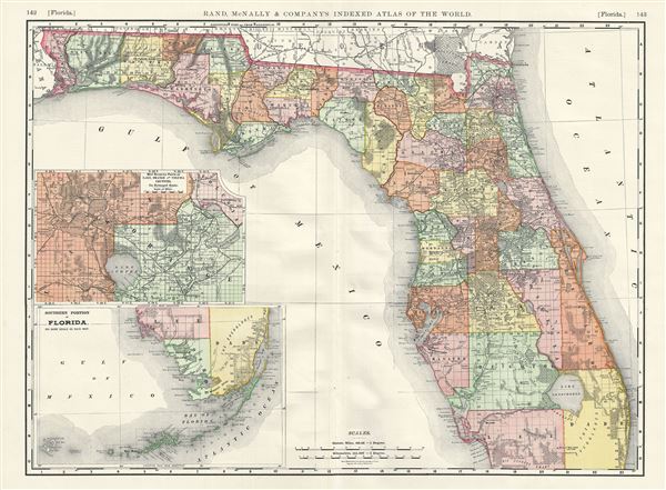
Florida.
1892 (dated) 20 x 27 in (50.8 x 68.58 cm) 1 : 1180000
1892 (dated) 20 x 27 in (50.8 x 68.58 cm) 1 : 1180000
Description
A beautiful 1892 map of Florida issued by Rand McNally and Company. The map covers the state of Florida in its entirety along with parts of adjacent Georgia. An inset in the lower left quadrant details the southern portion of the state including the Florida Keys. Another inset map details parts of Lake Orange and Volusia counties on an enlarged scale. The map delineates survey grids and plats referencing the work of the U.S. Land Survey. Makes numerous references to forts and battle sites related to the Seminole Wars. Lake Okeechobee, the Everglades, Biscayne Bay, Tampa Bay and the Okefenokee Swamp are identified. Overall, the map is highly detailed with cities, towns, railroads, swamps and other topographical details also noted. Map is color coded according to counties with elevation rendered by hachure. This map was issued as plate nos. 142 and 143 in the 1893 edition of Rand McNally and Company's Indexed Atlas of the World- possibly the finest atlas Rand McNally ever issued.
Cartographer
Rand, McNally and Co. (fl. 1856 - present) is an American publisher of maps, atlases and globes. The company was founded in 1856 when William H. Rand, a native of Quincy, Massachusetts, opened a print shop in Chicago. Rand hired the recent Irish immigrant Andrew McNally to assist in the shop giving him a wage of 9 USD per week. The duo landed several important contracts, including the Tribune's (later renamed the Chicago Tribune) printing operation. In 1872, Rand McNally produced its first map, a railroad guide, using a new cost effective printing technique known as wax process engraving. As Chicago developed as a railway hub, the Rand firm, now incorporated as Rand McNally, began producing a wide array of railroad maps and guides. Over time, the firm expanded into atlases, globes, educational material, and general literature. By embracing the wax engraving process, Rand McNally was able to dominate the map and atlas market, pushing more traditional American lithographic publishers like Colton, Johnson, and Mitchell out of business. Eventually Rand McNally opened an annex office in New York City headed by Caleb S. Hammond, whose name is today synonymous with maps and atlases, and who later started his own map company, C. S. Hammond & Co. Both firms remain in business. More by this mapmaker...
Source
Rand McNally & Co., Rand, McNally & Co's Indexed Atlas of the World, (Chicago) 1893.
Condition
Very good. Original centerfold exhibits minor wear. Text on verso.
References
Rumsey 3565.095 (1897 edition). Philips (atlases) 1026 (1898 edition).