This item has been sold, but you can get on the Waitlist to be notified if another example becomes available, or purchase a digital scan.
1923 Rand McNally Map of Florida
Florida-randmcnally-1923$175.00

Title
Rand McNally Standard Map of Florida.
1923 (undated) 20.5 x 27.75 in (52.07 x 70.485 cm) 1 : 1140480
1923 (undated) 20.5 x 27.75 in (52.07 x 70.485 cm) 1 : 1140480
Description
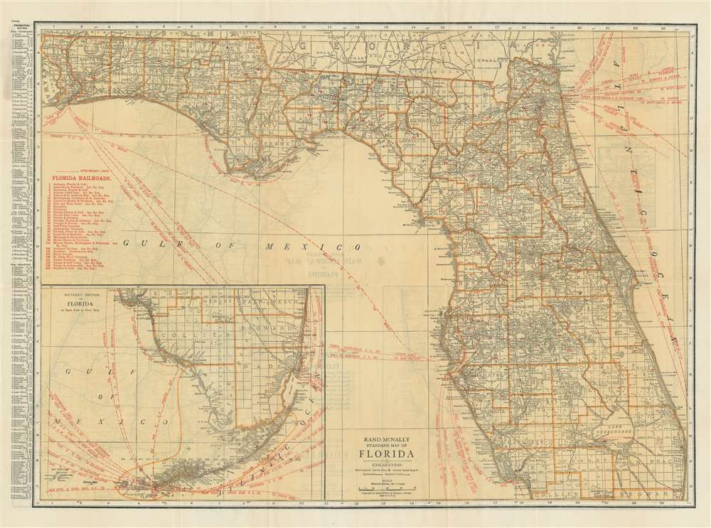
A transportation map at its finest, this c. 1923 Rand McNally map of Florida traces the state's railroad lines and steamship lines. Thirty numerically identified railroad lines crisscross the state and correspond with an index situated along the left border. Steamship lines are illustrated by dashed lines that leapfrog from one port to the other. Nearly every line is identified by the company operating the route, but all promote the intended destinations, which include New York City, Europe, South America, Africa, and the Far East. An inset map, situated in the lower left corner, details southern Florida and the Florida Keys. Key West is a hub for steamship travel: ten lines head west for locations along the Gulf of Mexico, and another five point east, heading for ports along the East Coast of the United States and in the Caribbean.
Publication History and Census
This map was created and published by Rand McNally and Company c. 1923. It is part of a series that was updated regularly as new steamship lines came into service. The Touchton Map Library at the Tampa Bay History Center has several examples we believe to be earlier editions, some of which are dated, thus our presumed date of 1923. We have not been able to trace another example of this edition.Cartographer
Rand, McNally and Co. (fl. 1856 - present) is an American publisher of maps, atlases and globes. The company was founded in 1856 when William H. Rand, a native of Quincy, Massachusetts, opened a print shop in Chicago. Rand hired the recent Irish immigrant Andrew McNally to assist in the shop giving him a wage of 9 USD per week. The duo landed several important contracts, including the Tribune's (later renamed the Chicago Tribune) printing operation. In 1872, Rand McNally produced its first map, a railroad guide, using a new cost effective printing technique known as wax process engraving. As Chicago developed as a railway hub, the Rand firm, now incorporated as Rand McNally, began producing a wide array of railroad maps and guides. Over time, the firm expanded into atlases, globes, educational material, and general literature. By embracing the wax engraving process, Rand McNally was able to dominate the map and atlas market, pushing more traditional American lithographic publishers like Colton, Johnson, and Mitchell out of business. Eventually Rand McNally opened an annex office in New York City headed by Caleb S. Hammond, whose name is today synonymous with maps and atlases, and who later started his own map company, C. S. Hammond & Co. Both firms remain in business. More by this mapmaker...
Condition
Very good. Light wear along original fold lines. Road map of Florida on verso.