
This item below is out of stock, but another example (left) is available. To view the available item, click "Details."
Details
1940 Rand McNally and Pure Oil Map of Florida
1940 (undated) $190.00
1938 Rand McNally Pictorial Tourist Map of Florida
Florida-randmcnally-1938$150.00


Title
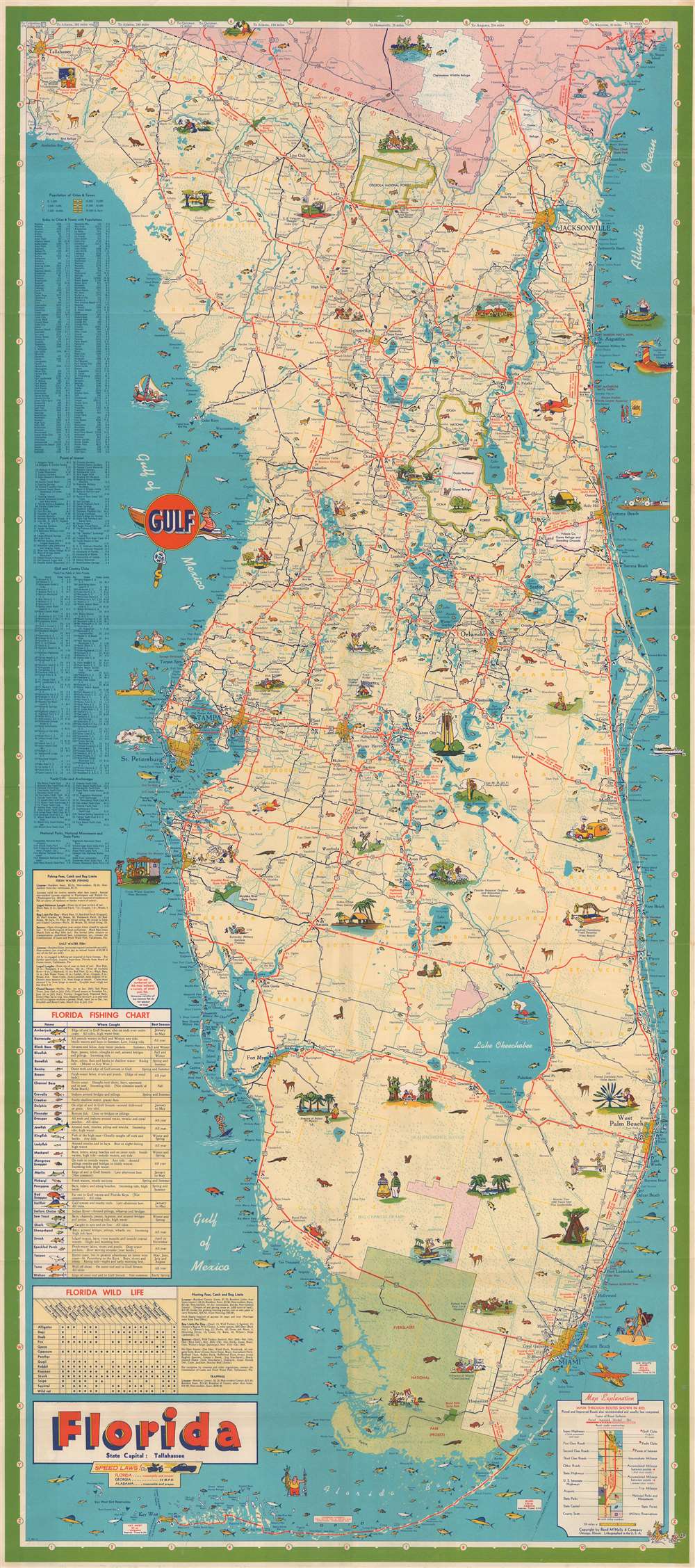
Florida.
1938 (undated) 39.5 x 17.625 in (100.33 x 44.7675 cm) 1 : 633600
1938 (undated) 39.5 x 17.625 in (100.33 x 44.7675 cm) 1 : 633600
Description
This is a 1938 Rand McNally and Company pictorial tourist map of Florida. Pictorial vignettes highlight tourist activities, modern conveniences (airplanes and automobiles), and tourist sites, including Bok Tower and Silver Springs. Everglades National Park (which would not be officially established until 1949) is labeled as a 'project'. Red lines highlight state and federal highways. A table containing illustrations of thirty-two different fish that can be caught off Florida's coast occupies the left border. It provides potential fishermen with information on where each species is caught and what time of year is best for each one. Nineteen of these fish have a number associated with them, which is used as an identifier for the small illustrations along the coastline. A hunter's guide appears along the left border as well.
Verso Content
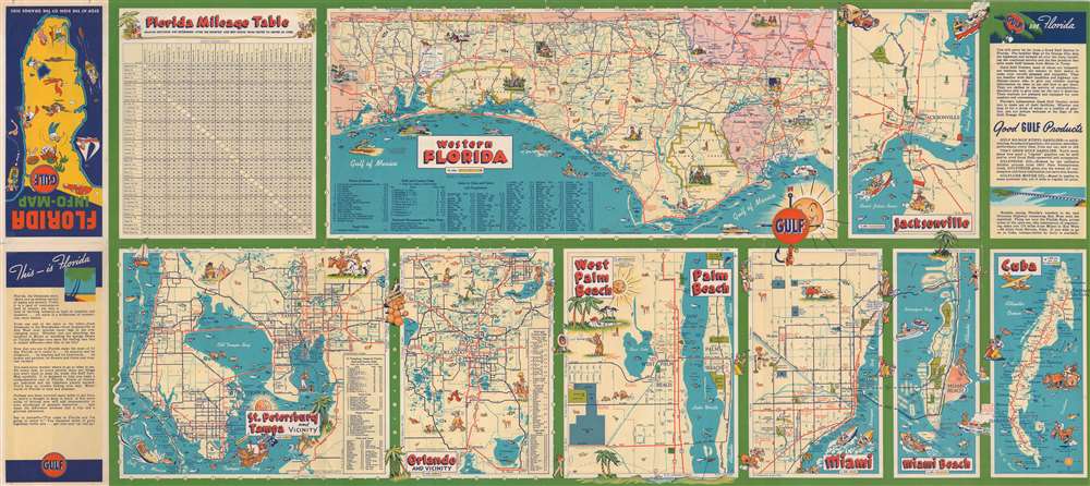
Multiple smaller maps illustrating many of Florida's cities are printed on the map's verso. The largest of these does not focus on a city. Instead, it depicts the Florida Panhandle from Tallahassee west to the Alabama border. The other maps highlight Jacksonville, St. Petersburg, Tampa, Orlando, West Palm Beach, Palm Beach, Miami, and Miami Beach. A small map of Cuba, then a popular tourist destination, particularly from southern Florida, occupies the lower right corner.Publication History and Census
This map was created by Rand McNally and Company for Gulf Oil and was published in 1938, with later editors appearing well into the 1950s. An example of this map is part of the collection at the Touchton Map Library at the Tampa Bay History Center. We also note four examples cataloged in OCLC which are part of the collections at the Newberry Library, the University of Kansas, Stanford University, and the Bibliothèque nationale de France.Cartographer
Rand, McNally and Co. (fl. 1856 - present) is an American publisher of maps, atlases and globes. The company was founded in 1856 when William H. Rand, a native of Quincy, Massachusetts, opened a print shop in Chicago. Rand hired the recent Irish immigrant Andrew McNally to assist in the shop giving him a wage of 9 USD per week. The duo landed several important contracts, including the Tribune's (later renamed the Chicago Tribune) printing operation. In 1872, Rand McNally produced its first map, a railroad guide, using a new cost effective printing technique known as wax process engraving. As Chicago developed as a railway hub, the Rand firm, now incorporated as Rand McNally, began producing a wide array of railroad maps and guides. Over time, the firm expanded into atlases, globes, educational material, and general literature. By embracing the wax engraving process, Rand McNally was able to dominate the map and atlas market, pushing more traditional American lithographic publishers like Colton, Johnson, and Mitchell out of business. Eventually Rand McNally opened an annex office in New York City headed by Caleb S. Hammond, whose name is today synonymous with maps and atlases, and who later started his own map company, C. S. Hammond & Co. Both firms remain in business. More by this mapmaker...
Condition
Very good. Exhibits light wear along original fold lines. Verso repair to a fold separations. Exhibits slight loss along a fold confined to margin. Maps of cities in Florida, other locations, and mileage table printed on verso.
References
Tampa Bay History Center Touchton Map Library M1277. OCLC 966642743.